City walls survey
2 Pockthorpe Gate
|
|
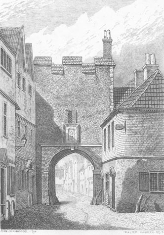
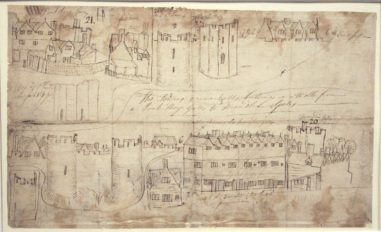
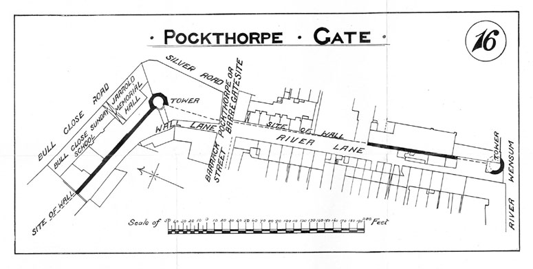
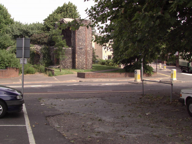
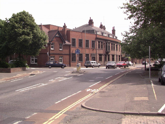
General descriptionThe gateway was just over 100 metres north of the river. [Map 02-01]The ditch on the outer or east side was presumably wide possibly over 20 metres and relatively deep carrying away surface water from Mousehold Heath. By the date of the earliest views, the ditch had been culverted and buildings encroached on the gate on all sides. [2] By the late Middle Ages, buildings ran up to the wall on both sides of Pockthorpe Road 18th-century drawings of the gate show, on the east or outer side, [3] a substantial brick archway around the opening with a semicircular arch with, apparently, key block and impost blocks in stone. The square top to the brick work and the nature of the brick work itself suggest that this was part of late-medieval or even possibly later consolidation work or repairs. Within the archway can be seen the ribs of vaulting which were presumably medieval. The archway had large stones set against the sides of the arch to protect the fabric from damage by carts passing through. In fact the south side of the arch is shown, nevertheless, to have extensive damage to the brickwork. Immediately above the arch was a rectangular carved plaque with a brick surround and a small rectangular window with diagonally leaded lights. The main block of the gate is robust or stark with plain flint work and roughly squared stone quoins at the outer angles. There were just three merlons across the front and a brick chimney stack at the north side serving the chamber over the gate. The crenellations are finished with bricks or tiles set on a slope. The inner or west side of the gate [1] still retained much of its medieval fabric in the 18th century with substantial square-set angle buttresses, the main brick archway, which appears to be primary, and a two light window with Y-shaped tracery lighting the upper chamber. The buttresses have brickwork at the outer angles and do not rise to the parapet but are finished at an angled off set with a slope of tile level with the top of the chamber window. On the south-west corner is a small block with a sloping roof that must have contained a staircase to the chamber. The doorway into the stair shown on the west side is square headed and does not appear to be medieval work. The view by Henry Ninham produced in 1864 but based on drawings by John Kirkpatrick of about 1720 shows the wall to the north of the gateway, heading towards the first intermediate tower at Bull Close Road." The crenellations appear to be more tightly spaced than in other parts of the city. This may suggest a different and later date for this work. The section of wall shown does not show an arcade on this section of wall to support a wall walk. The three-storey building on the north side of the road on the inside of the gate survived until at least the late 19th century when it was known as the Dove Inn. Documentary evidenceLike several of the gateways, Pockthorpe Gate has been referred to by several names. In 1272/73 it was called 'Barregate', in 1322/23 it was referred to as 'Le Barregates' and in 1339/40 as 'Barrechate'. The name Pockthorpe came from the name of a small hamlet and grange or manor that grew up outside the city, beyond the gate, just to its east. Although generally, in other parts of the city, work began on building the wall and gates in the 1290s it appears that the work at Pockthorpe was not begun until at least 30 years later. It appears that, in part, the delay was caused by a dispute between the city and the Prior of the Cathedral over who owned some of the land required for the new work. The remains of an earlier Saxon ditch have been discovered running between Bull Close Road and the river on a line much closer to Magdalen Street. [Norfolk Archaeology vol. XXXVI 1976, pages 196-199] The implication is that the line of the defences along what is now Bull Close Road and running down to the river at River Lane reflects a deliberate enlargement of the city to the north east that encroached on and cut across the Prior's manor of Pockthorpe. There was also a dispute over who was responsible for upkeep once the wall was completed. In 1326 Katerine, widow of Reginald Pope, granted or sold land in the parish of St James to the city. The boundaries of the plot were clearly defined in documents. It was between the common ditch of the city on the east side and the tenement of Katerine Pope on the west side, abutting the King's way on the south and the common ditch to the north. [Dom. Civ.] This appears to be the land on which the wall north of the gate and the polygonal north-east tower were constructed and presumably included space for Wall Lane. The use of the term ditch suggests that the wall in flint was, at that stage, still to be built. Work on the gate was, presumably, in progress in 1338 for a document of that year records that William de Claxtone, Prior of Norwich, gave one great plank to 'Barrechate' which cost 4s. and gave 40d. and 12d. to the workmen there. [Comp. Cam.] In 1344/45 John, son of Robert de Kirkeby, granted and sold to the city one piece of land out of his close in St James' parish at Barregates. This land lay between the land of the Communality to the east and his land to the west containing in breadth 14 feet and in length as much as his said close extended. [Civ. Dom.] If the gateway was still not completed, this would explain why in 1342 Pockthorpe was not one of the gates that was armed with 'espringolds' paid for by Richard Spynk. On the Feast of St Mark (25th April) in 1346 Richard de Lyng, parson of Redham, John de Berneye and John Chenele granted a piece of their land at Le Barregates for the wall and lane there. The land stretched from the King's way to the King's river called Wensum. [Dom. Civ.] Presumably, this land was required to complete the building of the wall from the south side of the gate to a tower on the bank of the river. A Customs' Book dating from the 14th century, from the reign of Edward III, records the number of battlements in the circuit of the defences. The wall and towers north of the gate, between Pockthorpe Gate and Magdalen Gate, had 178 battlements, Pockthorpe Gate had 10 battlements and the wall and tower to the south of the gate about 40 battlements. [Fitch page x] Again, this list was presumably compiled to help decide what repairs were required and to determine who was responsible for the work. In 1385 a survey was undertaken to assess the condition of the wall. Each gate and the towers and the sections of the wall between the towers were maintained by the relevant ward with responsibility vested in appointed wardens. The list of wardens in 1386 is recorded on a surviving Roll. The Wardens of 'Baryates' included:
In the 15th century there were further disputes about the responsibility for repairs to each section and in 1451 an Agistamentum or distribution of the burden of repairs was issued. Fibrig ward was responsible for Fibrig (Magdalen) Gates 'with al the walles and toures unto the next tour on the north side of Barre Gates.' East Wymer Ward on the south side of the river 'shall have the said toure and Barre (Pockthorpe) Gates, and alle the walles unto the toure in the water, and the same toure; with the dongeone by ye Hospitall Meadowes on the north est corner.' [Fitch page xvii] In 1460 it was stated that the wickets at Pockthorpe were to be kept by a soldier, 'who shall attend to let people in and out.' [Blomfield page 163] Pockthorpe Gate was damaged during Kett's Rebellion of July 1549. After the Earl of Warwick crushed the uprising, the gate was 'made new'. [Fitch page xxiii]. The document does not indicate precisely how much of the gateway was rebuilt but later views suggest that actually much of the medieval fabric was retained. In February 1643, during the Civil War, the gate was ramped up with earth or 'rampired'. It is not clear from the description but it would appear that earth was piled up behind the gate to seal it. On the 31st May 1757 it was ordered that the 'flashings and battlements' on the gate should be repaired and the breaches in the city walls should be repaired. [Tonnage Book] The gateway was demolished in 1792 following an order from a Quarterly Assembly held on the 21st September. Map evidenceOn the map by Cunningham of 1558 and the Speed map published in 1616, the gateway is depicted as having two turrets which is clearly wrong. Both maps are drawn, in part as views from the west and the gateway is on the furthest point on both of the maps. Hochstetter's map of 1789 shows buildings right up to the gateway on the outside, that on the south side of 'Pockthorpe Street' being a large courtyard house. On the inner side of the gates, there were then no buildings on the south side of Bargate Street, simply garden plots. The map shows a building west of the gate with a frontage on to the north side of Bargate Street and a range running back along the lane inside the wall but nothing adjoining the gate. The Ordnance Survey map of 1887 (sheet LXIII.II.9 surveyed in 1883) shows that the wall to the north of the gate, between the site of the gate and the tower at the junction of Silver Road and Bull Close Road, survived. The precise position of the gate is, nevertheless, difficult to establish as illustrations show the gate with later buildings hard against it and it is not possible to establish where the wall abutted the gate on the north and south sides. However, the need to leave access to the lane inside the wall to the north, and the way in which the buildings against the wall on the north taper in as they approach the gate, implies that the wall abutted the gate towards the inner or west side. That would suggest that the gateway projected out into the ditch. [4] The site of the gateway today:The site of the gateway is beneath Barrack Street just before a very busy road junction with a small roundabout at Silver Road on the inner ring road.[5 & 6]. The line of the wall north of the gateway is laid out in modern cobbles in a small public garden around the remains of the tower at Bull Close Road. [see Report 3 on Bull Close Road tower and wall] To the south of the site of the gateway, the land is presently owned by Jarrold's. Part of the wall between the gateway and the river survives within the printing works [see Report 1 on River Lane] but is, in part, screened by a glass corridor. Again the line of the wall near the gateway is laid out in modern cobbles. No records were found of systematic archaeological excavations on the site of the gate nor do there seem to be any reports of accidental finds of footings of the gate or the bridge over the ditch during the course of building work or road works. If the City Council wished to have an information panel here about the lost gate it would be appropriate to incorporate this with any display panel or information panel erected for Bull Close tower immediately to the north of the site of the gate. BIBLIOGRAPHY:Blomefield, Francis, An Essay Towards the Topographical History of theCounty of Norfolk, vol. III: The History and County of Norwich Part I (London: W. Bulmer, 1806) Fitch, Robert, Views of the Gates of Norwich made in the years 1792-3 by the Late John Ninham (Norwich: Cundall, Miller, and Leavins, 1861) Hudson, William, and Tingey, John C., The Records of the City of Norwich, vol. II (Norwich & London: Jarrold & Sons, 1910) DOCUMENTS AND UNPUBLISHED PAPERS:N.R.O. Book of Customs (last leaf) See also: HISTORIC VIEWS IN THE DATABASE:Kirkpatrick, John The Tower and remarkable buildings on ye walls fromPockthorpe Gates to Maudlin Gates, NWHCM 1894.76.1746:F [2] DOCUMENTARY REFERENCES:
HISTORIC ILLUSTRATIONS IN THE DATA BASE:Norwich Castle Museum and Art Gallery, The Tower and remarkablebuildings on ye walls from Pockthorpe Gate to Maudlin Gate by John Kirkpatrick., 1894.76.1746: F. Norwich Castle Museum and Art Gallery View of the outside of the gate about 1720 by John Kirkpatrick and engraved by Henry Ninham in 1864., 1954.138, Todd 5, Norwich 115a Norwich Castle Museum and Art Gallery,View of the inside of the gate about 1720 by John Kirkpatrick and engraved by Henry Ninham in 1864. 1954.138, Todd 5, Norwich 115b View of the east side. Robert Fitch, Views of the Gates of Norwich, 1861 opposite page 29 View of the west side. Robert Fitch, Views of the Gates of Norwich, 1861 opposite page 31 |