City walls survey
5 Magdalen Gate
|
|
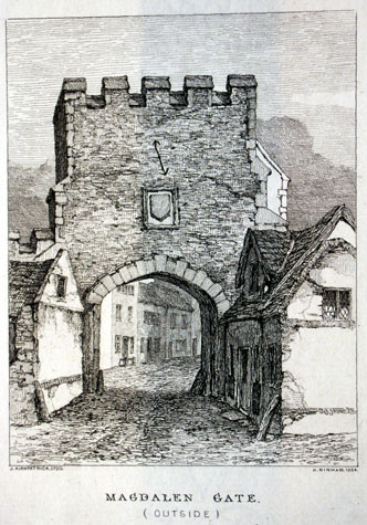
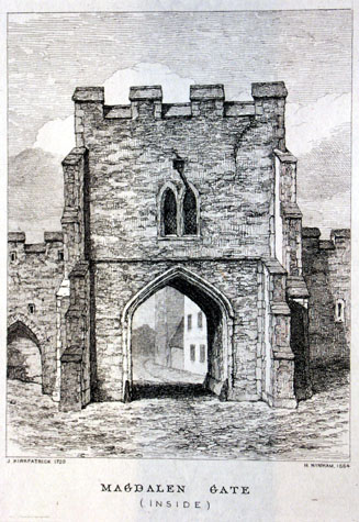
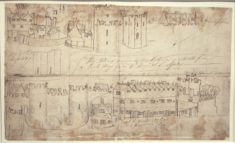
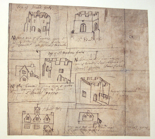
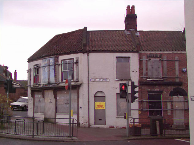
General descriptionMagdalen Gate was north of the river, some 1100 metres due north of the castle. From the gateway, entering the City, Magdalen Street runs initially north south but after crossing the river at Fye Bridge it veers to the east and enters Tombland in front of the precinct of the Cathedral. Frank Meeres, in his History of Norwich, suggests that the line of Magdalen Street and its continuation south along King's Street, south of Tombland, may follow the line of the Roman Road. The gateway appears to have been relatively compact with a roughly-square plan with corner buttresses at each of the angles. It appears to have been of flint with brick or possibly stone dressings to the arches and to the buttresses. Ninham's views of the gateway about 1790 [Fitch opposite page 27 and opposite page 28] show five relatively narrow battlements to both the outside and the inside. This is difficult to reconcile with the mid 14th-century Court Roll that records that the gateway had 13 battlements. The gateway had an upper chamber the north or outer side had a central plaque over the gate arch with a small single-light window higher and to the east. [3] On the City side the chamber was lit by a two-light window with Y-shaped tracery which could, on stylistic grounds date from the 14th century. The view of the inside fa�ade of the gateway also shows a rainwater hopper immediately above the window and a drain pipe running diagonally out to the south-west corner of the gateway. This would suggest that the roof of the upper chamber was well below the high parapet. On the inside of the gateway there was an unusual arrangement of buttresses which suggest alterations following settlement or partial collapse. At the outer angles, at the south-east and south-west corners of the gate, were substantial angled buttresses rising to just below the battlement with four off sets. Within these and rising to a string over the archway were square-set buttresses. [4] Kirkpatrick's sketches of the upper part of the gateway from the east, drawn about 1720, [Castle Museum 1894.76.1686:F] [5 & 6] depicts two intermediate merlons on the east side, the southern of which incorporates or has been adapted to form a chimney stack. There are two loops to the upper chamber on the east side or more probably these loops were from the space above the roof but behind the high parapet. Curiously, the drawing shows two doorways below the loop, that to the south with a round or arched head and that to the north beyond the line of the wall. The south doorway was either the doorway from the chamber to the wall walk to the east or was the doorway at the top of an external flight of steps. There is no indication in Ninham's views for the position of a staircase within the tower though the external view of the gate does show a sloping roof or sloping parapets on the right or west side giving access from the chamber to the lower wall walk to the west. The wall, shown beyond the building adjoining the gate on the north-west side, has the broad merlons found elsewhere in the wall. This is the section of wall that in part survives. [See Report 6] The view of the inside of the gateway engraved by Henry Ninham [Castle Museum 1954.138,Todd 5, Norwich, 114a] shows clearly the first arch of the wall and wall walk to the west but suggests that there was no corresponding arcade to the east but simply an arrow loop. It is likely that the first intermediate tower to the east was relatively close to the gate (possibly only about 9 metres) and a wall walk may have been thought to be unnecessary. This view also shows clearly the way in which the lane inside the wall on the west side of the gateway climbed steeply up from the level of Magdalen Street much as it does now. The view of the outside of the gateway in Fitch shows the road approaching the gateway between embankments with what appears to be a thatched barn on the east side of the road with its gable end to the road. It is difficult to interpret, from the view, how closely the buildings on either side of the gate encroach on the ditch but the implication is that by the late 18th century the ditch, at least on either side of the gateway, had been filled in and buildings constructed. Kirkpatrick's pen and ink sketch of the gate, 'Top of Maud. Gates' shows ten battlements (although this might be representative, rather than actual). A stair turret appears visible to the centre of the top of the gate, and a buttress extends to the left of the gate as it is viewed. Inscribed beneath the sketch the artist has written: 'NB There are 5 Towers upon the walls between Maud. Gates & St. Aust's. All seems circular'. Robert Dixon's much later pencil and watercolour, 'Under the Old City Walls, St. Magdalen Gates, Norwich' , c.1808-9 [NCM 1904.67.3:INT], shows that the top of the gate tower is crumbling, with no battlements to be seen. Immediately to the left of the tower is a building which appears to abut the side of the gate, with further attached buildings to the left. Immediately adjoining the right of the ruin is a double gable fronted house, apparently built on to the back of the walls. As this gate was demolished in 1808 this is an important contemporary depiction. Documentary evidence:The account of the work undertaken at the expense of Richard Spynk shortly after 1338 is recorded in an account of his works in 1343. This was published by Tingey and Hudson, and includes a short description of the new works at Magdalen Gate.
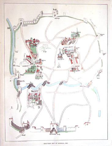
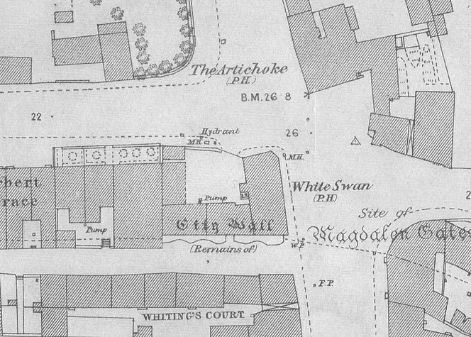
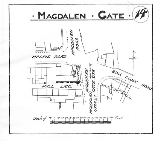
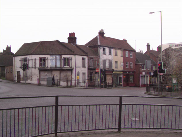
Blomefield mentions that in 1377 the gate had 13 battlements, and from there to Pockthorpe Gate there were 178 battlements on the intervening walls and towers. [Blomefield, page 98, citing the Book of Customs] In 1460 three soldiers stood regularly on guard at Magdalen Gate, which was the responsibility of Fibrigge ward, as were 'all the walls and towers to Bar or Pockthorpe gate, on the N. side.' [Agistment for the Walls, 1451, 1481, Liber Albus, f. 177; Hudson & Tingey, vol. Ii, pages 313-15] Magdalen Gate was burnt by the rebels during Kett's rebellion of 1549, after which the gate 'was made new.' [Blomefield, page 259] Gallows were built outside the gate, and after the rebellion, according to the Norwich Rolls, 30 traitors were hanged, drawn and quartered there, as an example to others. [Norwich Rolls, as cited by Blomefield, page 255] These gallows were still in use over fifty years later, when, in 1615, one Thomas Tunstall, priest, was hanged, drawn and quartered 'at the gallows out of Magdalen-gates'. His head was spiked upon a pole at St. Benedict's gate, and his quarters hung from four other city gates. [Blomefield, page 366] In 1643 Magdalen gate was rampired up with earth, presumably as a precaution during the Civil War, and this was later removed. [Blomefield, page 386] The Tonnage Books for the city of Norwich for the 18th century mention the gate several times, as noted by Fitch. [page 28; N.R.O. NCR Case 19 shelf C] In 1749 it was ordered that one William Clarke, mason, repair the doorway he had made through the wall near this gate, which he was using as a passage-way to and from his house. In June 1756 it was ordered that the front of the gate be rebuilt, the wall to the east of the gate removed, and a buttress built in its place. An advertisement was placed in the Norwich Mercury to give notice of the repairs, and the gate was taken temporarily out of use. In 1783 the gate was whitewashed. Map evidence:The redrawn Sanctuary Map of 1541 [Castle Museum 1954.138, Todd 5, Norwich 172] [7] shows the gateway clearly as it is in the foreground of the map. There appears to be a chimney stack for the upper chamber on the east side and the upper part of a stair turret to the roof at the south-west corner. The ditch to the west is coloured to show that it is filled with water and there are high parapet walls to the bridge running out hard from each side of the gate arch forming a barbican. Kirkpatrick's map drawn about 1700 appears to show buildings on the outside of the wall over the line of the ditch on both sides of the gateway. More significantly, Kirkpatrick marks the position of the first of the intermediate towers to the west of the gate. This was semicircular in plan and possibly just 23 or 24 metres from the west side of the gate. Hochstetter's map of 1789 shows the ditch to the west of the gate still open and with a fence along the edge of the ditch between the ditch and the outer lane. The tower was still standing and the gate is shown as projecting out over the ditch. Presumably the close proximity of a tower to the west of the gate was a deliberate tactic for the defence of the gate. All the surviving towers have loops in the angle between the outer face of the tower and the outer face of the flanking wall to provide sight lines along the wall and potentially covering fire. Here such loops would provide crucial cover of the vulnerable flank of the gate at the lower level and a platform from which to cover the bridge and the approach to the gate at the level of the wall walk. There is no clear map evidence for the position of the tower to the east of the gate but here, just 12 metres from the gate, the wall turns southwards towards the river making a tower here doubly crucial. The close proximity of flanking towers to the gate emphasises the importance of Magdalen Gate as a principal entrance into the city. St Stephen's Gate [report 25] had a similar arrangement of towers flanking and protecting the gate. There, both towers were vaulted providing a larger platform at the upper level for artillery defending the gate. By the late 19th century the ditch was completely covered and terraced houses were built along the line of the wall. The first edition of the Ordnance Survey map of 1885 shows buildings on the west side of the site of the gateway right against the wall and these are identified as the White Swan public house. [8] The report on the city walls in 1910 by Collins included a sketch map of the site of the gate and of the surviving wall to the west. [9] The site of the gateway today:Magdalen Street retains the remains of several major medieval houses and the modern street frontages respect the width of the medieval street. Beyond the site of the gate, over the line of the ditch, is a major and congested road junction. Part of the wall survives immediately to the west of the site of the gate but there is nothing to mark the position of the gate itself. [Map 05-01] [10] Archaeological reports:No archaeological investigations have been undertaken in the area of the gate although test drilling for building work behind the house on the east side of Magdalen Street determined the depth of the ditch to be about 7 metres some 15 metres east of the gate. [see report 4] [11]
BIBLIOGRAPHY: See also: DOCUMENTARY REFERENCES: HISTORIC ILLUSTRATIONS: |