City walls survey
7 Magpie Road
|
|
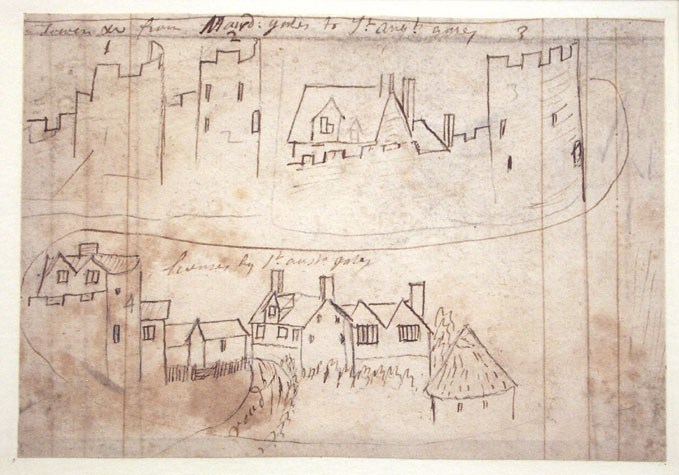
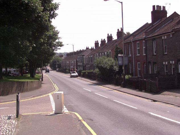
Documentary EvidenceThe city walls were completed or existing gates and towers were strengthened about 1340 at the expense of Richard Spynk, a wealthy citizen of Norwich. The work he financed is set out in an account in 1343 that was transcribed and published by Tingey and Hudson. That account implies that Spynk was responsible for the construction of 45 rods of the wall between Magdalen Gate and St Augustine's Gate and four towers. [Extract from The Old Free Book, Hudson & Tingey, Vol. II, page 217] A rod could denote a unit of volume in building work, commonly for a wall 1 feet thick, but here it probably defines a unit of linear measurement equal to 16 feet. That means that the work undertaken about 1340, as well as the building of four towers, included about 226 metres of wall. Unfortunately, the rod was not a standard length throughout the medieval period and could vary from place to place. Even so this document is significant as the distance between the gates was 365 metres which would suggest that the rebuilding of the wall had been abandoned with this section of the wall only partly finished. The same document states that Spynk completed Magdalen Gate which had been left at the level of the vault and we know from other documents that the area further east around Pockthorpe Gate was one of the last sections of the wall to be completed. The wall around the city was almost certainly not rebuilt in a rational way starting at one point and working round year by year but this document does reinforce the idea that the north part of the city wall was the last part to be rebuilt and that work may have been completed working from west to east. At a court held on the 29th August 1676, it was ordered that �25 should be bestowed for the repair of the walls between Magdalen and St Augustine's Gates. [Fitch page 26] In 1910 there was no visible evidence for the position of the first three towers to the west of Magdalen Gate. The survey of 1910 states that 'The only evidence of the City wall in Magpie Road is to be found at the Magpie public house, about one-third of the way from St Augustine's Street to Magdalen Street. It is a small piece of the foundation cropping out the ground against the East wall of the house this was possibly also the site of the second tower East of St Augustine's Gates.' The public house survives but there is now no external evidence of surviving wall although it is said that part of the wall is visible in the cellar and that may be part of the base of a tower. A drawing of details of this part of the wall by John Kirkpatrick about 1720 survives in the Castle Museum. [2] Along with drawings of the tops of the gates is a sketch of the top of the tower next to St Austin's gate. This shows an open, semicircular tower with battlements. Inside the tower is a tall house with a steep roof and a curious dormer with a pair of gables. [NWHCM: 1894. 76. 1686: F] A note on the drawing clearly states 'NB there are 5 Towers upon ye wall between Maud: gates & St Aust' All semi circular.' Map evidence:Historic maps vary in accuracy and detail but provide crucial information about the area immediately around the wall in the post medieval period. Cunningham on his view of the city in 1558 shows just a single tower between Magdalen Street and St Augustine's, Kirkpatrick in the early 18th century shows five towers and all semicircular. [NWHCM 1894.76.1682: F] Cleer's map of 1696 shows four of the five towers and Corbridge's map of 1747 just three towers. All four maps show that the large triangular area between Magdalen Street and St Augustine's Street was not developed and there were no buildings against the wall, either on the outside or the inside. However, King's map of 1766 shows buildings along the south side of the lane inside the wall encroaching from each end. Although the map shows only four towers, it does show clearly that the tower at the west end, close to St Augustine's Gate, was on the angle of the wall where it turned from running east west to run to the south west to join the gateway. This is the tower that survives in part in the Magpie Road printing works. [see Report 8] By 1789, the date of Hochstetter's map, there were buildings hard against the wall on both the inside, on the line of the inner lane, and on the outside, actually over the ditch, which must, by that stage, have been infilled. Hochstetter shows clearly the first intermediate tower west of Magdalen Street. This is shown as circular and is about 40 metres from the gate. The early 19th-century maps by Millard and Manning show the second tower from the east as semicircular and open on the south or inner side. The same map also appears to show that the first tower from the east may not have been circular in plan but may have had a polygonal plan to the south or inner side similar to the surviving tower on Coburg Street. [See Report 23] By 1885, the year of the 1st edition of the Ordnance Survey map, there were terraced houses along the full length of Magpie Road, all built over the line of the ditch. General assessment:This section of the wall, on the north side of the city, has been encroached upon by late 19th-century terraced housing and little survives above ground apart from short sections of the wall and its arcades at each end. [3] The wall is clearly visible at the east end by the site of Magdalen Street Gate with open access to the public but the large section of wall behind the Magpie printing works can only be seen from Catherine Wheel Opening. There is no opportunity here to exploit the wall either for landscape potential or for visitors and tourists. Archaeology reports, future conservation and potential excavations:The only evidence from this section at the time of writing is two SMR reports. The first for 104 Magpie Road [NF420] reports only that a sherd of Delft, a sherd of Westerwald stoneware and an 18th-century clay pipe were found in a sewer trench dug through the city ditch in 1979. The second [NF26155] revealed part of the city wall in the back yard of 134 Magpie Road in 1957. This was at a depth of 6" to 9", while the edge of the wall, of flint and mortar, was revealed about 7" from the back wall of the house. The back wall of the house over lay the rest of the medieval wall. This is the house at the east end of Magpie Road that is immediately to the west of the house with a section of flint wall surviving at the end of the yard. [see Report 6, survey drawing] With housing along the full length of Magpie Road and the importance of the road itself, there is little prospect of further archaeological work apart from the need to stipulate a watching brief should work be undertaken on the houses or services along this section. Future excavations could determine the position and plan of the intermediate towers.
BIBLIOGRAPHY: DOCUMENTARY
REFERENCES: See also: HISTORIC
ILLUSTRATIONS IN THE DATA BASE: |