City walls survey
9 St Augustine's Gate
|
|
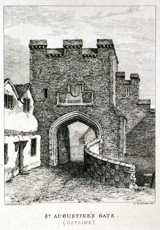
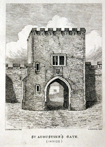
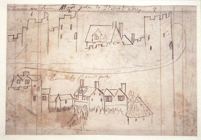
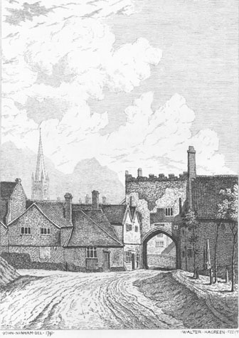
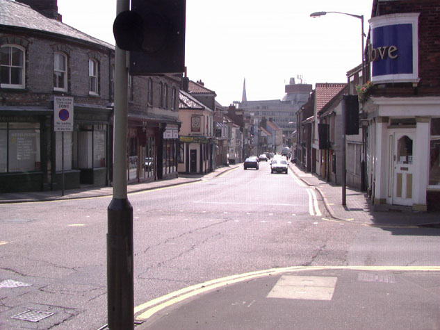
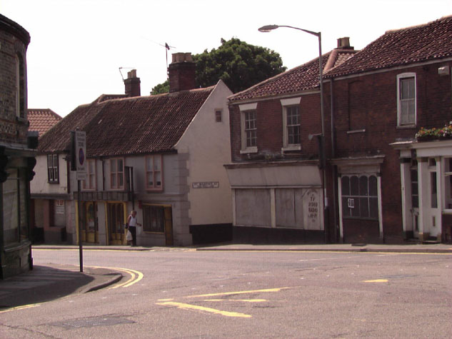
General DescriptionThe engraving of the outside of the gateway by Henry Ninham, based on the drawings made by John Kirkpatrick in the 1720s, shows that the gate was set forward of the flanking walls. [1] The outer face had just three battlements. Above the archway of the gate was a large group of three carved shields, one over two, with a narrow loop just to their east, to the first-floor chamber, which, presumably, gave a view out to the approaching road for guards in the chamber. The wall to the west of the gate is clearly shown with a high ramped parapet protecting the steps leading down from the chamber to the wall walk. On the north-west corner of the gateway was a substantial buttress with, apparently, large stone quoins. On the west side of the arch was a high parapet with a coping and a chequer-board effect that was probably panels of brick and flint. This parapet formed a barrier on the edge of the bridge over the ditch and the steep ditch is indicated to the right or west side of the view. By that stage cottages with gabled dormers had encroached onto the bridge on the east side and appear to have been built hard up against the wall to the east of the gate. On the city side of the gateway Kirkpatrick's view shows that there was a buttress at the south-west corner and two small windows, one above the other, on the west side of the arch suggest that the staircase to the upper chamber was at the south-west corner. [2] This would give a reason for the buttress which would have reinforced the corner of the gateway if the wall was weaker at this point because of a vice built within its thickness. Presumably access to the vice was by way of a doorway just inside the gate arch on the west side. The upper chamber was lit by a large square-headed, two-light window looking down onto St Augustine's Street and there was a coat of arms filling the space between the sill of the window and the apex of the arch. The form of the window is not medieval and it must be a 15th or 16th-century alteration; several of the gates retained arched windows with Y-shaped tracery up to the 18th century. On this side of the gate there were seven battlements. The quoins to the corners and on the buttresses appear to be stone rather than brick. This early view shows blank walls flanking the gate implying that there was not an arcade to support the wall walk at least immediately either side of the gate. A sketch of the upper part of the gateway by Kirkpatrick [Norwich Castle Museum 1894.76.1686:F] shows clearly the round-headed door on the east side of the gateway that gave direct access from the upper chamber to the wall walk running towards Magdalen Gate. [3] This drawing also shows a chimney stack against the east side that is clearly a later addition to serve a fireplace inserted in the east wall of the chamber. John Ninham's depictions of the inside and outside of the gate in 1792 [4 & 5] [Fitch, 1861], show the general decline of the state of the gateway during the 18th century. On the outside the coats of arms seem to have been removed exposing bare brickwork and a square-headed, three-light window had been inserted. The face of the gateway and the battlements appear to be eroding. There are 6 merlons and these are in brick. The wall is no longer visible to the left or right of the gate, and large buildings abut the wall to the right (parallel to the wall), while smaller ones abut to the right and left. [NCM Fitch Collection 1771.76.94] Ninham's view of the inside of the gate [Norwich Castle Museum Fitch Collection 1772.76.94] appears to show the gateway faced completely in brick (or is this repairs?) There are three iron braces or strengthening ties: one to the top middle, and one to either side of the gateway, as shown in Kirkpatrick, above. The large archway contains a single wooden door and the archway appears to have a ribbed vault. A chimney on the east side is clearly shown. Houses on St Augustine's Street appear to be built right up to the wall on both sides allowing no space for a lane. Documentary evidenceAlso known as St. Austin's gates, a typical medieval truncation of the name, the Porte St. Augustine is mentioned in a deed of particular lands lying outside the gate, to Hamon, Master of St. Giles Hospital, during the time of Henry III. [SMR NF261; Fitch, page 25] This is significant as Henry died in 1272. A gate and by implication a defensive wall or fence and ditch must have existed here before the walls and gates of the city were built or rebuilt in the work after 1294. In 1291 or 1292 (19th Edward I) Roger, son of Richard de Augustine was fined 6d because he undermined the walls here and the Prior of Norwich was fined half a mark because he fed his swine upon the ditch here. Two years later Robert de Readham was fined 12d for carrying away a tree valued at 6d from St Augustine's Gate to his own house. [Rot. Let. Quoted by Fitch, 1861 page 25] These local court cases are significant in that they illustrate the continual problem of maintaining the ditches. Presumably the ditches were filled with rubbish and sewage but pigs grubbing around would have broken down the embankments. Trees were a problem but were also valuable so anyone caught steeling them was punished. Sometime between 1338 and 1343 the gate was improved and this work was carried out at the expense of Richard Spynk, a wealthy citizen of Norwich. The work undertaken at that time was recorded in an account produced in 1343 that was transcribed and published by Tingey and Hudson. 'And at St Austin's gate the groove of freestone in which the portcullis slides, and the portcullis with the machinery, and the gate covered with timber, board and lead and bars and chains at the entrance.' [Extract from The Old Free Book, Hudson & Tingey, Vol. II, pages 217] At an Assembly in 1507 or 1508 (22nd Henry VII) Robert Shirreve 'carriour' was granted the farm of the gates of Fybrigge (Magdalen Gate) and St Augustine's with the ditch between them (ie they were leased to him) for the relatively large sum of 16s 8d a year. This was on the condition that he kept the ditch clean without beasts or cattle. It is unclear from this if Robert Shirreve obtained an income from this investment by duties as a porter on the gates and charging for this service or if, by then, houses and buildings in the towers or against the walls provided a return from rents. In 1624-5 a Mr Pye was questioned as to what right he had to build houses over the gate. [Fitch, page 26] The occupants begged leave to be able to continue dwelling there, and this was apparently granted. These must surely be the houses depicted by John Kirkpatrick about 1720, as described above. In 1676 �25 was paid for the repair of the walls between Magdalen and St. Augustine's Gates, and �40 was paid to a mason for work done to the gate and immediate walls. [Fitch, page 26] Map evidenceThe 16th and 17th-century maps show little of the gateway though Hochstetter's map of 1789 does show clearly that by that stage there were buildings hard against the gate on both sides on the outer side and on the east side on the inside. The ditch along Baker's Road, west of the gateway was still open with a fence on the south side of the road, between the road and the ditch, and a hedge along the north side of the outer lane. However, it is possible that there were buildings all along the inner side of the wall facing on to St Martin's at Oak Wall Lane The sheet of drawings by Kirkpatrick [Norwich Castle Museum 1894.76.1686:F] includes a sketch of the top of a crenellated tower with a house built within it. [3] The house has a steep pitched roof with a tall dormer with double gables and two windows. The sketch is labelled 'house on ye top of Towr next St Austins gates' and must be the tower surviving within the printing works rather than the tower to the west of the gate. That is also shown on the drawing. The sketch of the top of St Augustine's gate on the same sheet of drawings shows the wall to the east of the gate abutting the gate at about the centre just to the south of the chimney stack serving a fireplace in the chamber over the gate. Kirkpatrick also shows a doorway with an arched head leading from the chamber onto the wall walk. This may in fact be inaccurate and this is significant when trying to reconstruct the line of the wall from the surviving section up to the gate on the east side. If Kirkpatrick's sketch is accurate the wall would have changed direction between the surviving section and the gate. However, the late 18th-century views of the gate by John Ninham show that the steps down onto the wall walk from the chamber were protected by a high, steeply sloping parapet and possibly a roof. Although the junction of the wall and gate is hidden by the houses around the gate, Ninham shows clearly that the steps ran up to the gate on the north side of the projecting stack. This would imply a more rational arrangement of the wall with it continuing in a straight line from the surviving section and abutting the gate at its outer north-east corner. Hochstetter's map of 1789, surveyed shortly before the gate was demolished, shows the wall to the east abutting the front or north-east corner of the gate while the wall to the west appears to abut the gate at about the centre of its west side. The map also suggests that the ditch to the east of the gate was wider than the ditch to the east. The significance of this asymmetry is difficult to understand without more evidence. It may reflect different dates in the construction of the wall on either side of the gate. It may reflect a feature of the landscape or a feature of the earliest gate that has now been lost. It may reflect a problem with building a bridge over the ditch when St Augustine's Street hits the line of the wall and ditch at an angle but any bridge was easier to construct if it was built at right angles to the ditch. The site of the gateway today:Ninham's view of the inside of the gate suggests that the modern St Augustine's Street retains the alignment and the width of the medieval street though beyond the site of the gate, over the line of the ditch, is a major and congested road junction. [Map 09-01 and photographs 6 & 7] There is no obvious reason from surviving evidence to indicate why the gate was not centred on the middle line of the street but was off set to the west. Part of the wall survives both to the east and to the west of the site of the gate but there is nothing to mark the position of the gate itself. Archaeological reports:No archaeological investigations have been undertaken in the immediate area of the gate although trenches were dug for building work behind the houses on the east side of St Augustine's Street. The houses at the corner of St Augustine's Street and Magpie Road (with a curved frontage) are said to have deep cellars which must have been constructed in the ditch. The outer face of the wall to the east of the gate was revealed at the end of a trench in the yard that ran outwards, north, from the wall. [see report 8]
BIBLIOGRAPHY:Blomefield, Francis, An Essay Towards the Topographical
History of the
County of Norfolk, vol. III: The History and County of Norwich
Part See also: DOCUMENTARY REFERENCES:N.R.O. Book of Customs (last leaf) HISTORIC ILLUSTRATIONS IN THE DATABASE:From the Castle Museum and Art Gallery:Kirkpatrick, John, c. 1720, 'Various Gates and Towers, Top of St. Austin's Gates', NCM 1894.76.1686:INT Kirkpatrick, John, c. 1720, 'Tower from Magdalen Gates to St. Augustine's Gates and Houses by St. Augustine's Gates', NCM 1894.76.1689:INT Ninham, Henry, 1864, from John Kirkpatrick, 'St. Augustine's Gate', NCM Todd Colllection Vol. II Box 5, page 113d Ninham, John, 1792, 'St Augustine's Gate, Outside', NCM Fitch Collection 1771.76.94 Ninham, John, 1792, 'St. Augustine's Gate, Inside', NCM Fitch Collection 1772.76.94 Pococke, Edward, 'Sixteen Drawings of the Gates of Norwich', NCM 1955.219:IN |