City walls survey
14 Heigham Gate
|
|
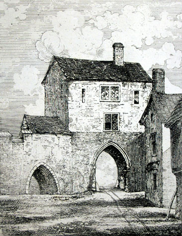
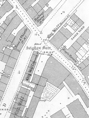
General DescriptionAn undated engraving attributed to James Reeve (apparently taken from a drawing by John Kirkpatrick of about 1720) shows a small postern gate with a single narrow arch, and with a two-storey house, or gate-house, on top. [1] No battlements are visible. The drawing is not captioned to indicate if the view is from outside or inside the wall. However, as the ditch here was wide and no ditch is indicated on the drawing then it is almost certainly the view from Nether Westwick Street looking out through the gate. In addition, an arch shown to the left of the gate must be one of the internal arches of the arcade that supported the wall walk. The gateway appears complete, with the wall and battlements to the left, with a building of some sort (which might be part of the building on top of the gate) abutting the other side of the wall. To the right of the gate the wall is not visible, as a large house abuts the wall here at right angles. [NCM 1894.76 FAW 306 :INT] The gate was demolished before John Ninham produced his illustrations in 1792, and so does not appear in the Fitch book. Documentary evidenceBlomefield's transcription of the last leaf of the Book of Customs records that 'on that gate [were] 4 battlements; thence to the river on the wall and tower 16.' [Blomefield, page 98] In 1440 it was found that 'certain tenements within the gates of Helle-gates' belonged to the Abbot of Holm's manor of Heigham, and were not included in Norwich Liberty. [Blomefield, page 153] In June 1742, Robert Brettingham, a mason was contracted to rebuild the gate which was to be 24 feet high. The gate arch was to be 10 feet wide and 13 feet high, presumably to the springing as it is described as clear. The side piers were to be 5 feet wide and the arch 10 feet deep. [This contract is quoted in Fitch, page 22] In 1910 Collins records that 'At No. 76 Barn Road, at the corner of Westwick Street, a piece of the foundation of the City wall may be seen under the shop floor with a flap in the floor to give access to it.' [Collins, 1910 page 72] This was either part of the wall immediately to the west of the gate or was part of the gateway itself. Map evidenceKirkpatrick's map from the early 18th century shows clearly the number of streams on this part of the river where there is now a single channel. The western arm of the river survived until the late 19th century for it is shown on maps as open water on the west side of the old City Railway Station. Kirkpatrick shows not only the gate and the wall to its north but also shows that the tower on the river bank was circular. Presumably it was similar to the tower west of St Martin's Gate and the Boom Towers on either side of the river at the south end of the defences. The first edition of the Ordnance Survey map surveyed in 1883 and published in 1885 [2] is of interest because it shows clearly the wall surviving hard on either side of the site of the gateway, well over a century after the gateway had been removed. This evidence shows that at this gateway the wall was set back from the front of the gate by an equal amount on each side. However, there was a change of alignment on the north side where the wall turned further to the east to run out to the bank of the river and the tower there. [14-01 Map] There are no surviving or visible remains of the tower by the river and no illustrations of the tower have been found. [3 & 4] Archaeological impact assessment:Any archaeological investigation of the site of the gate itself is now almost impossible as any surviving fragments are beneath the tarmac of a major road junction. The line of the wall to the north of the gate and the site of the tower on the river bank are within a car park and some investigation would be possible though there is no evidence that any parts of the wall or the tower survive.
BIBLIOGRAPHY:Blomefield, Francis, An Essay Towards the Topographical History of
the See also: DOCUMENTARY REFERENCES:N.R.O. Book of Customs (last leaf) HISTORIC ILLUSTRATIONS IN THE DATABASE:Reeve, James (attrib.), Norwich Castle Museum 1894.76 FAW 306 :INT |