City walls survey
15 Barn Road
|
|
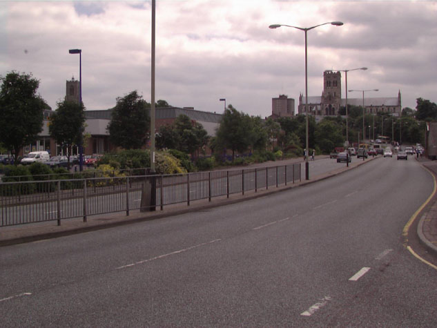
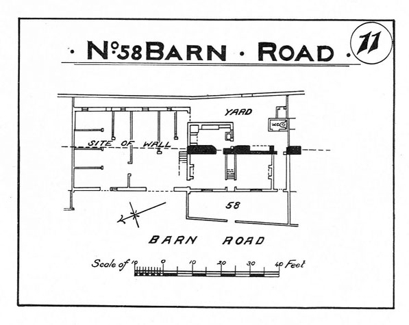
Documentary evidenceBlyth notes that in 1842 this section of wall was built upon, `within and without'. [Blyth, page 4] Map evidenceCunningham in his map or view of the city in 1558 shows clearly the river and the mill but just one tower between Heigham Gate and St Benedict's. The error is difficult to explain as this section of the wall is actually in the foreground. However, he also shows two intermediate towers and a long stretch of wall to the north of Heigham Gate so it is possible that he had to distort the wall to give extra space to depict as much detail as possible for the streets and buildings inside the city. Certainly Kirkpatrick's map of the city about 1714 [Norwich Castle Museum and Art Gallery NWCHM 1894. 76. 1686: F] appears to be much more accurate with two towers between Heigham Gate and St Benedict's that are shown to be evenly spaced. None of the 18th-century maps show the intermediate towers though the wall was still standing throughout the period. The full length of the wall between the two gates is shown on the map by A W Morant published in 1873. However, by that stage a large area of housing, mainly tightly packed rows of terraces, had been built outside the wall beyond the ditch and there was a large silk factory inside the wall. Obviously there was pressure to build over the site of the wall and ditch. By 1885, the date of the first edition of the Ordnance Survey map most of the north end of the wall seems to have been demolished and houses had been built over the site facing on to Barn Road. Just two short lengths of wall are shown, one section of about 15 metres immediately south of the site of Heigham Gate and a second shorter section slightly further south. [OS sheet LXIII.II.17] General descriptionNone of the wall survives and there was extensive clearance of the area after bomb damage in the Second World War. The precise line of the wall is not easy to determine north of the section that survives near the site of St Benedict's Gate. [see Report 16] There is presently a broad dual carriageway, [2] part of the inner ring road on the line of the ditch and a large car park on the inner side of the line of the wall. [15-01 Map] Archaeology. conservation and potential excavationsIn 1970 a bastion (TG22500905) was seen in a sewer trench near the Westwick Street junction. [SMR NF26013] Measurements of this were apparently taken by E B Green, but these have not been located. This was presumably the first of the two intermediate towers closer to Heigham Gate. Part of the wall survived until the early 20th century and was recorded on a sketch plan of 58 Barn Road that was published in the report of 1910. [3] Archaeological excavations around the south end of the Barn Road wall and south of St Benedict's Gate were undertaken by J Hurst and J Golson in 1951 and 1953. Their report published in 1957 came to several general conclusions that are applicable to the whole section of wall. It was felt generally that there had been an arcade on the inner side of the wall for the whole length of the wall between the gates. Damage to the wall, with buildings constructed against it in the 18th and 19th centuries, had caused so much disruption to the evidence that it was impossible to reconstruct the position and spacing of the arches or even to determine the precise line of the wall. The finds in the ditch implied that the ditch north of St Benedict's gate was filled in about 1750, some 50 years after the ditch south of the gate was filled. Map evidence, discussed above, suggested that at first small cottages and then larger houses were built in front of the wall between 1779 and 1789. Areas that were excavated suggested that the arcade had been filled with new flint work but that much of the outer face of the wall had been removed to create extra space for the houses facing outwards towards Barn Road. [Norfolk Archaeology Volume XXXI 1957, page 52] Evidence was uncovered for an extensive defensive bank and for a ditch predating the late-13th century flint wall. This was dated from finds to the middle of the 13th century which corresponds with documentary evidence for a licence granted to Norwich in 1253 to enclose the city. However, it is still difficult to reconcile this with the first documentary reference to Heigham Gate in 1221 which might imply that there was some form of defensive enclosure here by then. The flint wall at the south end of Barn Road was constructed over a shallow trench filled with compacted material with layers of mortar to form a base for the flint and mortar wall. There seems to be little need or scope for further excavations in this area unless there is an opportunity to excavate the site of the northern intermediate tower. BIBLIOGRAPHY:G K Blyth, The Norwich Guide and Directory (London: R. Hastings; DOCUMENTARY REFERENCES:See also: ARCHAEOLOGICAL REPORTS:SMR NF26013 |