City walls survey
20 St Giles Gate
|
|
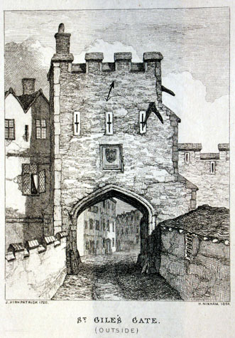
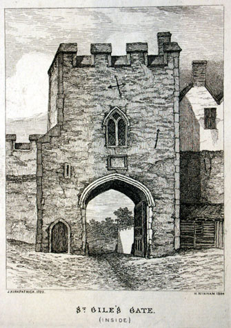
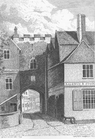
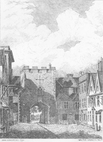
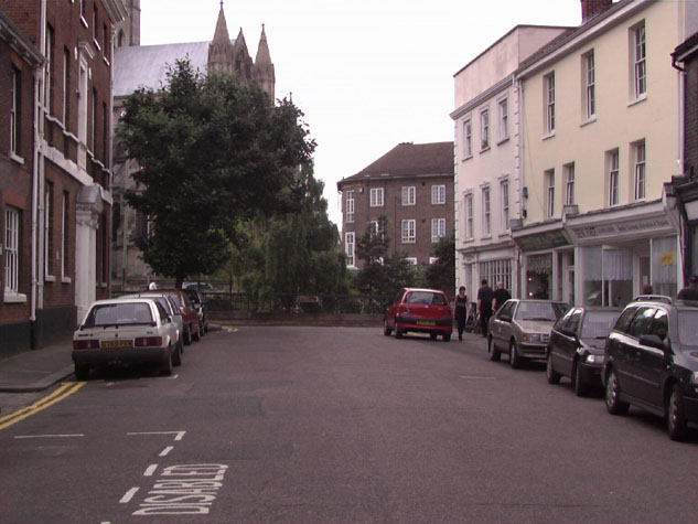
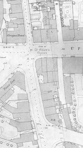
General descriptionJohn Kirkpatrick's depiction of the gate in 1720 was copied by Henry Ninham in an engraving of 1864.[NCM Todd Collection, vol. II, box 5, page 110a and 110b] He shows the gateway as relatively tall with four merlons to the outside [1] and four towards the City. Flanking the archway tightly on the outer side were the high parapet walls of the bridge over the ditch. That to the north was curved and crenellated. Above the archway was a single coat of arms said by Fitch to be the arms of the city. [Fitch 1861, page 16] Below this, he says, there was an inscription carved in stone that read: ADORNATA TEMPORE Above the arms are shown three cross-shaped loops which appear to be cut in stone. On the north side of the gateway is shown a chimney presumably serving a fireplace in the upper chamber and on the south-west corner is what appears to be a broad buttress with two off sets. The view of the inside of the gate shows a two-light window with Y-shaped tracery to the chamber over the arch and a plaque or inscription below the sill and above the arch. [2] The window, on stylistic grounds, probably dated from the middle of the 14th century. On the south-east corner is shown a low stair turret with its own low and arched doorway to the lane. The stair rises just to the chamber over the arch and the vice is lit by a loop at an intermediate level. Presumably there was either an internal stair or a ladder to give access to the roof over the chamber. The wall to the south is shown as surviving to its full height with crenellations but the wall to the north had been, in part, over built by a timber-framed house with prominent gabled dormers. John Ninham's drawings of the gate in 1792 (published by Fitch in 1861) show that the out side of the gate had been built against on both sides and the loops had been replaced with a cross-mullioned window with an arched head. [3 & 4] Also, on the inside, houses pressed hard against the gateway on both sides. [NCM Fitch Collection 1766.76.94] The three-storey house with a straight parapet shown by Ninham on the north side of St Giles survives. [5] This makes it possible to judge more accurately the scale and bulk of the lost gate. Documentary evidence:In 1290 flood waters ran right up to the foot of St. Giles Gate. [Blomefield, page 66] Blomefield notes that in 1377 on St. Giles gate and wicket there were 15 battlements, while the wall from St. Stephen's gate to St. Giles gate had upon it 229 battlements, and from St. Giles to St. Benet's gates there were 100 battlements upon the wall. [Blomefield, page 98, citing the Book of Customs] In 1451 and 1481 St. Giles Ward was responsible for the repairs to the walls, towers, and St. Giles Gates, to the tower on the north side of the gates, and that tower. [Agistment for the Walls, Liber Albus f. 177; Hudson & Tingey, vol. II, pages 313-15] In 1549 several breaches were made in the walls between St Giles and St. Stephen's during Kett's rebellion [Blomefield, page 248], and in 1643 St Giles Gates were rampired during the Civil war, the earth being later removed.[Blomefield, page 386] The Tonnage Books for 1756 ordered that the wall (sic) next to the gate was to be painted, the battlements repaired, and the top of the roof protected from wet by the placement of a lead ring. In 1763 the city ordered that the gate be repaired 'by proper workmen', and that the paving through and about the gate also be improved. [N.R.O. NCR Case 19 Shelf C; Fitch, page 16] Map evidence:Although maps of the city from the 17th and early 18th century show only a limited number of buildings near to the gate, by the time that Hochstetter completed his map in 1789, there were houses against the inside of the wall all down Grape Hill between St Giles' Gate and St Benedict's Gate. This was just before the gate was demolished and by that stage the ditch below the gate had been filled in and turned over to gardens. Millard and Manning's map of 1830 shows the then recently-constructed City Gaol outside the gate to the west and there were houses tightly packed around St Giles Street on the site of the ditch. The density of buildings over the site of the gate and ditch is shown clearly on the first edition of the Ordnance Survey map surveyed in 1883. [6] Present state: archaeology. conservation and potential excavations: With the widening of Grape Hill in the 1970s all these buildings were demolished. The level of the road was lowered by a considerable amount and archaeological evidence from the ditch and the bridge over the ditch must have been destroyed. The site of the gate is at the end of Upper St Giles Street, at the bottom of the ramp for the high level footbridge over the inner ring road. [7 & 8] In 1970 a stone was found built into or onto the city wall at about 3-4ft distance from the road. It has been suggested that this was a gate socket[SMR NF26171] BIBLIOGRAPHY:Atkin, Malcolm, 'The Chalk Tunnels of Norwich', Norfolk Archaeology, 38 DOCUMENTARY REFERENCES:N.R.O. Book of Customs ARCHAEOLOGICAL REPORTS:SMR NF261 1971 HISTORIC ILLUSTRATIONS IN THE DATABASE:From Norwich Castle Museum and Art Gallery: |