City walls survey
24 Coburg Street South
|
|
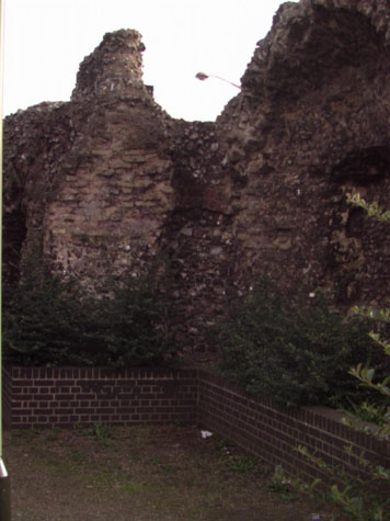
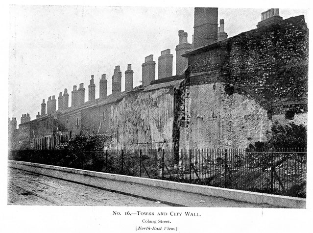
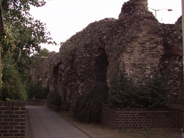
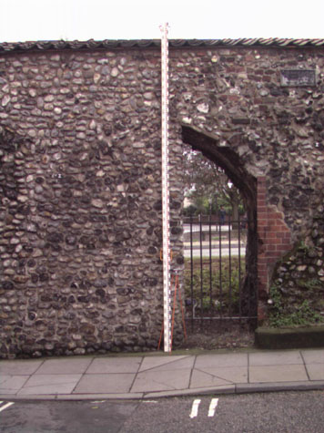
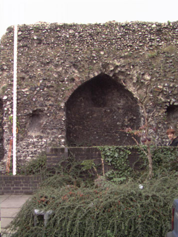
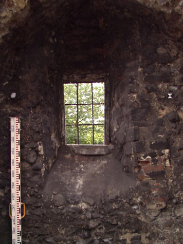
Historical Background ReportGeneral description of the historic fabric:To the south of Chapel Field East, following the line of what was Coburg Street, at present the western edge of the Nestle Factory site, there are five separate sections of wall between the south-west corner of the park and the site of the gate of St Stephen. There was an intermediate tower at the north end of this section but that was demolished in the 18th century when the wall was breached and a way through the wall created for the road now called Chapel Field East. At the centre of the section are the remains of a substantial two-storey polygonal tower, rounded to the outer side and three-sided towards the city. At the south end is the remains of an intermediate tower that was vaulted but may have been open to the inner side. [3 & 4] This was probably only a single-storey tower with an assembly point for troops patrolling or defending the wall at the level of the wall walk and would have facilitated cross fire to protect the approach and bridge to St Stephen's Gate immediately to the south. [24-01 Map] A number of arches survive on the inner side of the wall and the remains of loops or arrow slits mark the positions of other arches. [5] These all supported a wall walk that appears to have continued for the full length of this section. The arches and wall walk may not be a primary feature of the 13th-century wall. Documentary evidence:Because no documents have been discovered to date precisely the construction of the flint wall and the towers in this section, it has been assumed that, as elsewhere in the city, they were begun in the late 13th century. However some references in early documents suggest that part of this wall could be one of the first sections of the flint wall to be built and may date from about 1253. Parts of the Saxon and Norman settlement of Norwich were protected by a ditch and bank and many of the principle streets were laid out then so the site if not the structure of many of the gates may have dated from the 12th century. Although the citizens of Norwich were granted a licence by Henry III to enclose the city in 1253, it is generally believed that the flint-built wall was not begun until the raising of the first murage tax in 1294. [Fitch page v and page viii] However, reference is made to a wall (not a bank or ditch) in Chapelfield about 1256 (16th Edward I). In a Leet Roll from the 16th year of the reign of Edward I (1255/1256) the millers of the Prior of Buckenham had undermined the ditch between St Giles Gate and St Stephen's Gate and 'made a purpressure under the walls.' Purpressure generally refers to illegal enclosure or fencing in of land. The Prior's mill was in 'Chapply Field.' [Fitch page 12] Furthermore, in 1266 or 1267 John the Carpenter sold all 'his said messuage lying near the Gate of Needham', (St Stephen's Gate) to the Citizens and Commonality of Norwich, 'for their more convenient building of the wall of the city there.' [Dom.Civ. quoted by Fitch page 12] Throughout the medieval period the land here inside the walls seems to have been open without buildings. Known as Chapel Field, it takes its name form the chapel of St. Mary which stood on the site. Blomefield notes that in 1402 this chapel was a meeting place for assemblies. [Blomefield, page 119] In 1406 the citizens of Norwich 'claimed four acres and an half of ground which belonged to Chapel in the Field...lying in Chapel-field Croft, within the city ditch, on which it abutted south...' [Blomefield, page 124] This open area was much larger than the modern area of Chapelfield Gardens and extended south almost to St Stephen's. Blomefield cites the last leaf of the Book of Customs, which notes that along this stretch of wall between St. Stephen's and St. Giles gates were 229 battlements on the walls and towers. [Blomefield, page 98] In 1711 Kirkpatrick described the southern tower as horseshoe shaped. The photograph published in the 1910 report shows the back of the tower with fallen masonry which suggests that the photograph was taken as houses against the east side were cleared away. [6] It is difficult to see if the tower itself had been open or had been closed by a wall whose structure had been removed with this demolition work. Map evidence:Cunningham's map of 1558 is ostensibly a view of the city from the west and shows clearly the wall between St Giles and St Stephen's. Both gateways are depicted with bridges before them, both with two arches. The ditch in front of the wall is wide and appears to have a considerable amount of water in it. The view shows just five intermediate towers, all crenellated. It is impossible to make out any other details although the two towers at the St Giles end appear to be flat towards the outside ... that is of square or rectangular plan. All the sections of wall between the towers have distinct arrow slits. The area inside the wall is very open with cattle grazing. There are houses along the north side of St Stephen's and although Back St Stephen's (now Coburg Street) had been laid out, there were houses only on the south side and the north side was open to Chapelfields. By 1696, the date of Cleer's map, the open ground inside the walls had been bisected by a lane on the line of the modern Chapelfield East running directly up to the foot of an intermediate tower. There were no buildings along the lane on either side and no buildings against the wall itself either on the inner lane side or the outer ditch side. 'Chapply Field House' on the east side of the plot was obviously a substantial property and was set back from Chapel Field Lane, the extension of Horsemarket now called Theatre Street, with formal gardens laid out to its north. The map does not indicate a ditch on the outer side of the wall ... simply lanes hard against the wall on both sides. The map shows only four of the intermediate towers and certainly omits the southern horse-shoe shaped tower that survives.. Kirkpatrick, on a map of about 1714 [Castle Museum and Art Gallery NWCHM 1894.76.1682:F] marks just 5 towers between the gates. He shows clearly both the polygonal tower and the horse-shoe shaped tower to the south but omits a tower at the end of Chapel Field East. He shows two towers on the west side of what is now the park and also the first tower on the site of the Drill Hall at the north-west corner of the park. There are still no buildings shown close to the wall on King's map of 1766 but one version of this map appears to show the tower at the south-west corner of the park still standing. Hochstetter's map of 1789 shows the park much as it is now and still no buildings against the wall itself. Sections of the wide ditch are clearly marked particularly at the south end and it appears that the water in the ditch was used for watering cattle before they were brought into the city. The wall at the north end is not shown with a breach through it but nor is the intermediate tower here shown. Morant's map of 1873 shows houses built against the wall on the outer side. The plans of these houses with their small yards and outbuildings are shown in detail on the 25' Ordnance Survey map of 1883. This map shows that at that stage the south end of the wall survived right up to the house on the corner of St Stephens and may have formed the back wall of that house as well. The plans of the houses against the wall are also reproduced in the survey of 1910 [Report by A Collins, map 5]. The south end of the wall was still standing so at least 15 metres of the wall has been lost since 1910. The 1910 plan also shows that the wall between the towers curved inwards. It is not clear if this feature of the construction was defensive, providing better sight lines between the towers, or topographical, avoiding a ditch or drain. Historic views and historic photographs:A view of the wall at St Stephen's in the Castle Museum [1954.138, Todd 5, Norwich, 4] appears to show the south section of the wall on the inner side. [7] The position of the gap at the left end and the proportions of the house shown beyond the gap appear to correspond with the map in the 1910 report. The 1910 guide to the walls has photographs of the round tower and a view of the wall along Coburg Street from the north east.[8] The Archaeological Society at Garsett house holds copies of several photographs of the Coburg Street wall with several showing major work in progress. One is dated March 1908 and shows the arches at the south end propped with timbers as the houses against the wall were demolished. These photographs show clearly just how much of the wall collapsed as the houses and buildings against it were removed. The Society also holds photocopies of a proposed guide to the wall dated 1979. Archaeological reports:SMR NF260 reports the finding in 1972 of an iron staple from the flint and mortar buttress of the city wall opposite Caley's main gates. Caley's was the first factory on the Nestle site and was begun in 1921. The buttress was partly demolished by an articulated lorry pulling into Caley's yard. The iron staple is apparently part of a door fitting. An excavation at 42 Chapelfield Road in 1972 by J Roberts for the Norwich Survey examined the nature of the city wall foundations. Trenches, dug at right angles to the city walls, revealed that the foundations were very shallow, and had been cut into natural sand. The fillings of the city ditch along this stretch of wall were found to be rubble that dated from the late 18th- to 19th-century. [SMR NF236] An excavation for a sewer by the City Engineers, for 44-58 Chapelfield Road immediately to the north of this section, prior to the construction of the ring-road in 1973, took place within the fill of the city ditch. The excavation revealed that the fill was mainly of foundations and modern demolition/backfilling. [SMR NF196] In 1974, sewerage trenching operations in front of 60-102 Chapelfield Road were carried out outside the city wall in advance of constructing the inner link dual carriage way. This work extended north-east to south-west along the outer side of the city walls and revealed 'Disturbance almost wholely of the 18th century - 20th century for houses backing onto the city wall with rubble from their demolition'. [SMR NF196] In 1975 an underpass for the inner link road was dug from inside the city wall to the west pavement of Chapelfield Road. [SMR NF260] No trace was seen in this section of the defensive ditch. SMR NF372 gives a full account of the transition of the area, and a secondary file exists, but does not contain much information of use which is directly relevant to the walls or towers in this area. A Department of the Environment Report [HSD9/2/1005 part 6 contained in Gressen Hall file 384] mentions maintenance work to be carried out on the section of wall and towers from Chapelfield Road North to St. Stephen's Gate in 1988. CONDITION SURVEYList of known repairs:Not available at this stage. Summary of present condition:There is a wide gap of just over 25 metres in the line of the wall between the north section of Coburg Street [report 23] and this main section with arches. There are the remains of three arches north of the gap and there were six complete arches in this section that have been lost. [24-02 Plan] The fourth section starts at the north end with the remains of a number of arches. [24-04 Int Elev] There are the lowest parts of four arches before the wall rises rapidly where there are two almost-complete wall arches on the inner side and the jamb and springing in brick of a seventh arch at the south end.[9 & 10] This section of wall is over 25 metres long and a maximum of 5 metres high on the outside. After a narrow gap of 3 metres is the last section of wall. This includes the remains of a circular tower and to its south five almost-complete arches on the inner side of the wall [11 & 12] and on the outer face of the wall are the remains of a further two arches. [13 & 14] The fifth arch on the inner side and the two arches to the south, now only visible on the out side of the wall, are more closely spaced and are at a slightly lower level. Again this must reflect a different phase of building. Where these south arches added against the inner side of a standing section of flint wall? The wall ends with a substantial section ... again well over 4 metres high. The wall is breached by a narrow gateway within the blocking of an eighth arch. [15 & 16] This has a modern iron gate and appears to have been cut through the wall to provide access from the yard of what was 104 Chapel Field Road giving access through to Coburg Street. This last section of the wall has a sloping top which is protected by a roof with clay pantiles. South of the inserted gate the wall thins down rapidly and finishes some 27 metres north of St Stephen's Street and the site of the gate way. This section, from the tower to the south end, is 39.4 metres long and corresponds with the back walls of numbers 98 to 108 Chapel Field Road. The tower is in a poor state of repair. [17] It survives to the height of the main parapet walk and had a lower chamber or space that was vaulted. There are the remains of loops or arrow slits on both sides that were lined with brick and look down the face of the wall to the north and south. [18] The tower may have been open on the inner side. The stone vault would have provided an upper area for marshalling troops defending this section of the wall. The vault is broken away on the inner side and requires repair and consolidation. [24-06 South Sec] [24-07 North Sec] [24-08 3D from NE] The arches are in a reasonable state though most of the brickwork of the arches has deteriorated or has been lost completely. [19 & 20] As a consequence much of the facing flint above the arches has also been lost. Each of the arches had an arrow slit in the rear wall that was formed in brick. [21 & 22] These were later either blocked or enlarged to form windows, for the houses built against the walls in the 18th and 19th centuries. [23 & 24] There is a clear line on the inner face of the wall, close to the top, that marks the position of the wall walk although most of the parapet has been taken down and on the inner edge the wall walk has collapsed causing the gradual erosion of the arches. This has exposed much of the core work of the wall. Along the whole of this section of wall, from the polygonal tower to St Stephens, there is no conclusive evidence in the structure that the arches are an integral part of the surviving primary wall. Unlike brickwork or stonework, it is difficult to see with flint if the work courses or bonds in and is therefore primary. Although it is not proven conclusively, the flint work of the piers of the arches appear to have been built against the main wall as if they are secondary. Principal conservation problems:1. Collapse of arch topsAt the north end of this section of wall across the tops of the surviving arches are badly damaged with water penetration and many of the bricks have been lost. The arches here are not in as poor a state as those in Barn Road but it is recommended strongly that a specialist engineer's report is commissioned to assess and monitor the stability of the arches. The close proximity of the public foot path means that falling flint work would certainly pose a threat to the general public. It is also recommended that the bank should be reinstated for the whole length of this section of wall and the footpath moved further away to the east which would resolve part of the problem. 2. Shedding flints on the face and top of the wallParticularly a problem on the round tower and on the top of the wall to both sides. In the section north of the tower, the tops of the surviving arches have broken back as water has entered the flint core. Several large areas of flint need to be consolidated ... see above. 3. Intrusion of woody stemmed plantsNot as much of a problem as on many sections of the wall. Small area of buddleia on the outer side of the tower should be cleared. There are a number of well-established self-seeded bushes within the polygonal tower and these should be removed. 4. Potential problems with the vault of the round towerThe front edge of the vault is badly broken away and the parapet walk appears to be trapping water. The structure of the vault and its stability must be checked by an engineer and the upper surface must be re-pointed to stop water entering the core of the vault. 5. Deterioration of the brickworkThis is a common problem throughout the circuit of the walls. Once the wall walk deteriorates and collapses or in part collapses, water gets into the core and the wall over the arches is particularly vulnerable. The brick is relatively soft and once water penetrates the brick work crumbles and breaks away. Virtually no facing bricks survive on the arches north of the tower and the exposed brick is vulnerable both to weather damage and to being dislodged. Generally, the brick work of the loops is protected particularly where the arches are almost complete south of the tower. |