City walls survey
27 Brazen Doors
|
|
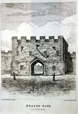
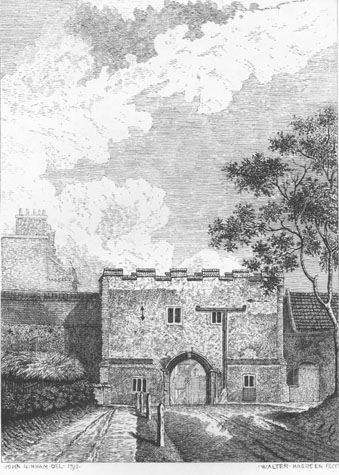
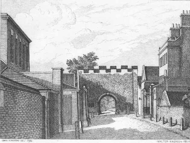
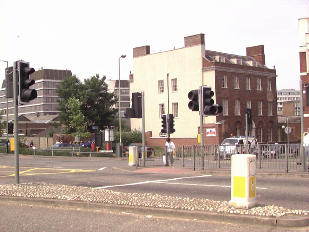
General descriptionJohn Kirkpatrick's depiction of the gate in 1720 (engraved in a copy by Henry Ninham in 1864) shows a low but wide gate with a central arch and 6 merlons across the top. [NCM Todd Collection, vol. II, box 5, page 118] There are single square-headed loops on either side of the gate arch and 4 separate narrow loops to the chamber over the gate. Three spouts throw out water from the roof behind the parapet. The central spout over the arch appears to have been fitted with a hopper and drain pipe running out to the side to stop the water discharging directly onto the road. Across the front, between the ground floor and the first floor is shown an angled off set cut by the arch. This may suggest that the gate had been heightened. [2] There is no indication of the ditch across the front which must have been filled in by then. On the inside of the gate the offset was repeated at the same level. There was just a single central loop to the chamber. John Ninham's view of the outside of the gate in 1792 [3] shows that the loops had been replaced by square-headed and mullioned windows on both levels. [NCM Fitch Collection 1762.76.94] The lower windows had shutters which dropped down from hinges on the sill. The archway had brick jambs...presumably the work of 1726...and there were vertical bands of brickwork at the outer corners, not quoins, which presumably reinforced the flint work. The merlons of the battlement were capped with brick or tiles and there were also sloping courses of brickwork between the merlons. The wall to the north appears to have been heightened or a building on the inside had been constructed against and over the wall. There is the indication of a cross at the top of the medieval wall marking a loop between the merlons of the battlement here. On the inside of the gate in 1792 [4], the fenestration had been altered and a doorway from the lane had been inserted into the chamber north of the arch. Documentary evidence:The Treasurer's Accounts for 1384 record that £19 3s 4d was spent 'erecting the walls near Iron Doors.' [Hudson & Tingey, vol. II, page 48] This is a substantial amount of money and might imply that the work involved extensive alterations to create the gate. Documents suggest that it was at some point in the late 14th century that the Swine Market was moved from All Saints Green to a new site outside the walls which could provide a specific reason for creating a new passage through the wall. The ancient assessment for repairs in 1451 and 1481 showed that St. Stephen's ward was responsible for repairs 'to the Iron Door, and all the towers and walls to Nedham, now St. Stephen's-gates, and those gates.' [Liber Albus, f. 177; Hudson & Tingey, vol. II, pages 313-15 as cited in Blomefield, page 169] The change of name from Iron Door to Brazen Door is, in part, explained in a document of 1513 or 1514 (4th Henry VIII). Geofry Lounde paid 16d. for the farm (lease) of a tower with the door of brass 'called the Tower with the Brazen Dore.' [Comp. Cam. Quoted by Fitch page 9] In 1543 earth was piled across the ditch to form a 'Caunsey', presumably a cause way to replace the bridge. In 1549 Kett's rebels fastened the door up 'with great beams, and pieces of timber, and rampired up with earth and stones'. Apparently this was the first gate taken by the earl of Warwick's forces when they entered the city to break the rebellion. Afterwards the rampart was 'taken from its outside and laid on each side in the ditch, to enlarge the passage' [Blomefield, page 248] In 1630 the tower next to Brazen Doors was appointed as a plague tower, 'for the buryers, and for a prison for such infected poor as would not be ruled.' [Blomefield, page 376] It is not specified if this tower was to the north or to the south. The gate was repaired and altered in the Autumn of 1726. Documents related to this work are important because they actually give some dimensions for the gate and its archway. On 28th September 1726, Mr Benning the carpenter and Mr Freeman, stone mason, were given instructions that there should be just one pair of gates on the outside. Those gates were to be 8 feet and a half high to the springing of the arch and 8 feet and a half wide. Ninham's drawings of the gates are remarkably precise and appear to show no perspective...essentially they appear to be elevation drawings. In 1847, John Britton, in his paper on the gates, actually states that Ninham used a camera obscura to produce the drawings so, with some allowance, measurements can be scaled from the drawings. If the gate arch at Brazen Doors was about 2.6 metres wide then the gate overall would have been 11.3 metres wide and 8.5 metres high. Map evidenceCunningham's map of 1558 shows Brazen Doors with flanking turrets which is clearly wrong. The early map makers seem to have used the double turrets as a symbol for the gates to distinguish them from the intermediate towers even though only St Stephen's Gate and Ber Street Gate had turrets. The map does show that at that stage there were no buildings near the gate and no buildings on either side of the road running from the gate into the City. The land here appears to have remained open until the late 18th century. King's map of 1766 shows just a short row of buildings on the inner side of the lane inside the wall immediately north of the gate. St Catherine's Close on the south side of Surry Street (now All Saints Green) was built shortly after 1778 and is shown on Hochstetter's map of 1789. Ivory house opposite was not shown but must have been built immediately after the map was surveyed for both houses appear on Ninham's view of 1792 flanking the road immediately inside the gate. By 1885, the date of the Ordnance Survey map [Sheet LXIII.15.13] the wall on either side of the gate appears to have been cleared away completely. To the north, with their fronts to Queen's Road and small yards towards Bull Lane, there was a continuous terrace of substantial houses with bay windows. The line of the wall seems to follow the line of the main back wall of the houses with short service ranges and the yards beyond on the inner side so, as along Chapel Field Road, the wall may have been incorporated into the new houses. To the south the ground immediately beyond the gate was clear before there was a series of widely-spaced paired houses or villas. The site of the gate now:The site of the gate is now a very busy traffic interchange with traffic lights. [27-01 Map] There would appear to be no possibility of archaeological excavations on the site and little or no need for interpretation panels or general enhancement. [5 & 6] BIBLIOGRAPHY:Blomefield, Francis, An Essay Towards the Topographical History of the
DOCUMENTARY REFERENCES:N.R.O. MF/RO 29/3 f. 177 (Liber Albus) ARCHAEOLOGICAL REPORTS: HISTORIC ILLUSTRATIONS IN THE DATABASE:Ninham, Henry, 1864, from John Kirkpatrick, 1720, 'Brazen Gate', NCM |