City walls survey
29 Ber Street Gate
|
|
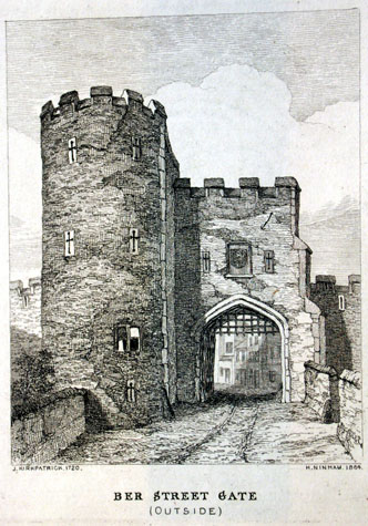
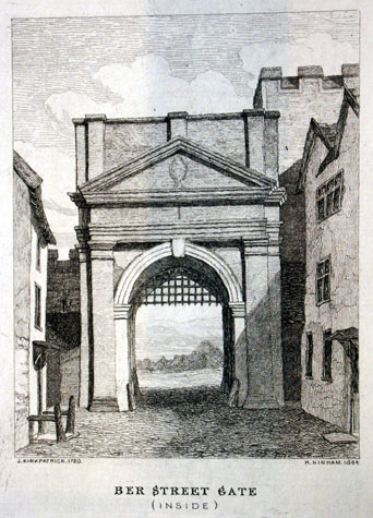
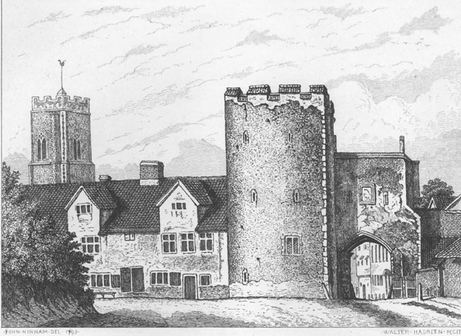
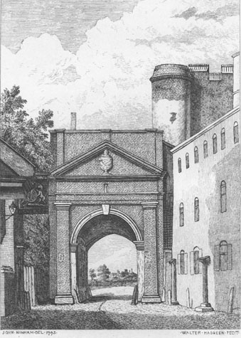
General descriptionKirkpatrick's views of the gate in 1720 were copied by Henry Ninham. [NCM Todd Collection, vol. II, box 5, page 117] The view from the south, showing the front of gate towards the ditch, has a single large tower to the west of at least three stories. [2] This was of semicircular plan to the outside and was crenellated and had cross-shaped loops to the first and second-floor levels. The form of these loops imply a date for the work in the 14th century rather than earlier. This might suggest that the towers were added to an earlier and simpler gate. Level with the springing of the arch was a cross-mullioned window that must, on stylistic grounds, have been secondary and below this, almost at ground level was another single cross-shaped loop. This low-level loop may have lit an undercroft in the tower. The archway appears to have a moulded stone surround with a four-centred head and above, at chamber level, was a central coat of arms flanked by loops. The parapet level over the arch was crenellated with four merlons. At the south east corner was an angled buttress with off sets. This buttress would have been added after the east tower was removed. Beyond the gate to the east and set back slightly is part of the wall with battlements...part of the section of wall that still survives at Ber Street. [see Report 30] The crenellated wall appears to be primary which would suggest that the gateway was asymmetrical with just the one tower to the west and no answering tower to the east. This seems slightly implausible and the answer may only be resolved by archaeological excavation. However, the wall just beyond Ber Street does turn to head south quite close to the wall and space for a second tower would be relatively restricted. The view also shows a high parapet wall on each side of the gate, that on the west meeting the tower at the centre of the arc of the front and that on the west meeting the gate at the centre of the inner angle of the buttress. These walls, a form of barbican, were the barriers between the bridge or causeway up to the gate and the drop into the deep ditch on either side. The view of the inside of the gate shows the main block with the archway refaced in brick with a pediment supported on pilasters. [3] Above the pediment was a high parapet with pilaster strips at the centre and inset from each end. The archway was closed with a portculis. John Ninham's drawings of the gate in 1792 (later published by Robert Fitch in 1861) show that some changes had been made to the gate and the state of the gate had deteriorated. [NCM Fitch Collection 1760.76.94] On the outside of the gate the battlements over the arch had been removed and the wall capped with tiles. [4 & 5] The parapet to the bridge on the west side had been removed and it appears that the ditch had been filled in and houses with gabled dormers built against the wall. The houses appear to be of 17th-century date with cross mullioned windows and this suggests that possibly the Kirkpatrick drawings or the engravings had been edited and some features omitted. Robert Fitch records that on the outside of the gate was set the City arms in plaster which was painted and had the inscription: REPARATA TEMPORE On a stone on 'the right hand' was REPARATA TEMPORE In the view of the city side of the gate, John Ninham shows the pedimented arch with a large urn within the pediment. To the east, above the roof line of a substantial three-storey house on the west side of Ber Street close to the gate, is shown the upper part of the surviving tower. Ninham shows clearly a sloping roof or possibly just the high angled parapet of the steps that would have led down from the upper chamber of the tower onto the wall walk to the west. He also shows a projecting circular stair turret against the north-east corner of the tower. This appears to have served the second floor chamber or 'solar' of the tower and appears not to have risen higher to give access to the roof of the tower. Documentary evidenceThe first references to Ber Street Gate are found in documents in the reign of Henry III in the second and third quarters of the 13th century in leases relating to Butter Hill. Blomefield, citing the last leaf of the Book of Customs noted that at that time there were 27 battlements on the gate and wicket, and between there and 'St Steven's gate in the towers and walls are 307.' [Blomefield, page 98] The remodelling of the gate financed by Richard Spynk is described briefly in an account of his work produced in 1343 and transcribed and published by Tingey and Hudson. This work included 'at Berstrete Gate the portcullis with the machinery, and the gate covered with timber, board and lead, and bars and chains at the entrance ... And at the two towers of Berstrete Gate, at the low tower a solar of timber, board and lead, and at the high tower a solar of timber and board, and another solar above with timber, board and lead.' [Extract from The Old Free Book, Hudson & Tingey, Vol. II, pages 217- 219] The work on the towers was jointly financed by the city. Presumably the tower with two solars is the three-storey tower shown on the drawing by Ninham and the lower tower was presumably on the east side of the gate and had been demolished by the 18th century. The construction of solars and the use of timber is slightly perplexing but Philip Dixon of Nottingham University has pointed out that accounts for defences elsewhere in England indicate that timber was used on the back part of semicircular towers or to form upper platforms. This timber could be removed and stored carefully to extend its life when there was no threat of attack. Many of the towers and the gates in Norwich were fitted out with at least some form of accommodation and this was, in later centuries, rented out or used by Hermits. Treasurer's Accounts for 1385-6 record that John Elmswell was paid 2s for 'making the ditch between the great Tower and Berstrete Gates. [Hudson & Tingey, vol. II, page 48] Presumably this was clearing the ditch rather than excavating a new ditch as the charge involved is relatively small. In 1460 three soldiers stood on guard at the gate, and the ancient assessment of Agistment for the Walls from 1451 and 1481 showed that the residents of Berstrete were responsible for repairs from the corner of Berstreet gates, and the walls and towers to the Iron Door. [Liber Albus, f. 177; Hudson & Tingey, vol. II, pages 313-15] In 1508 Alderman Robert Gardiner bequeathed �10 'to the Reparacon of Berstrett gats and to the Walles of the same Ward.' During Kett's rebellion of 1549 Ber Street Gate was burnt by the rebels [Blomefield, page 244] and in 1558 the gate was repaired, as well as the walls adjoining, 'to the cost of 43 (pounds) and upwards.' [Blomefield, page 276] Could that be when an east tower was removed? The Tonnage Books show that orders were given partly to pull down and rebuild the gate, facing it in red brick, in 1727. The gate and the walls were to be built 'from the foundation to the top of the arch, 2 feet 8 inches thick, at 2s 6d per yard; and from the top of the arch upwards, 2 feet thick, at 2 s per yard'. The wall was to be 3 feet thick, and 15 high; and the foundations to be 2 feet into the ground and four feet thick. The work was to be carried out in 3 months. [N.R.O. NCR Case 19 Shelf C; Fitch, page 7] Also in 1727 it was ordered that a lean-to be built against 'the Great Tower at Ber Street Gate'. This lean to is shown on a sketch of the gate drawn by John Carter in 1786 and engraved by J Walmsley and published in 1847. [History of the History and Antiquities of Norfolk and the City of Norwich, Proceedings of the Archaeological Institute opposite page 136] In 1806 a report was made as to the occupants of the gates. This revealed that Ber Street Gate had been used for some time as an Ordnance store (ibid.). In 1808 the gate was demolished. Map evidenceCleer's map of 1696 shows the gateway with two circular towers though this may be a graphic convention. The pair of towers are repeated on Hoyles map of 1728 which, in theory, post dates the rebuilding of the gate and postdates Kirkpatrick's drawing. Again the convention of a pair of towers is repeated on the map by Corbridge in 1747 indicating that these maps were derivative. Hochstetter's map of 1789 shows clearly that the wall survived on either side of the gate. On that map Ber Street is marked as Berg Street. The ditch to the west had been filled in and the ditch to the east and south had been planted with garden plots as far as the tower at the junction of Bracondale Road where the ditch ran down Carrow Hill. The site of the gateBer Street is no longer a main entry into the city though the traffic is nevertheless relatively heavy. [6] The road is narrow with parts of the wall surviving right up to the road on both sides. [29-01 Map] On the west side is a two storey brick outbuilding in the rear yard of number 244 Queen's Road. [7] It was probably a carriage house and dates from the 19th century but is built against and over what appears to be a flint boundary wall. This flint wall does not appear to include medieval fabric above ground but is certainly on the line of the defensive wall that ran from Ber Street Gate to Brazen Doors. The house on Queen's Road is built over the line of the ditch and actually has a cellar, presumably taking advantage of this. On the east side of Ber Street is a small public garden where an important section of the city wall survives. [8] The wall here turns sharply where the ditch and wall continued south towards the Black Tower. The wall here is important because it survives for its full height up to the parapet ... the only section of wall where the brick work of the merlons survives. This section of the wall was buried within the Richmond Hill public house which was demolished after 1910 and is now the site of the garden. [9] The change of alignment of the wall at Ber Street is easy to explain in practical terms. The ditch in front of the gate would have been crossed by a bridge with one or two arches. Generally, it is easier to build a bridge directly across a ditch or river at right angles. Here the direct line of Ber Street running north south took precedence and the ditch running from north west to south east was turned for a short distance to run west to east so that the bridge and road could be built straight across. If funds should be available for any archaeological work on this site then an excavation on the east side of the road might uncover the east side of the gate and could confirm the arrangement of an east tower. A pipe trench for road works in 1976, underneath the position of the gate tower, immediately to the west of the preserved section of the wall 'cut through a massive, flint in yellow mortar wall, presumably part of the gate.' [TG2354807712 SMR NF20] An information panel in the gardens could not only explain about the features of the surviving wall but could also include an illustration of the gate and an explanation about the ditch and the appearance of the wall in its original setting. BIBLIOGRAPHY:Blomefield, Francis, An Essay Towards the Topographical History of the DOCUMENTARY REFERENCES:N.R.O. Book of Customs (last leaf) ARCHAEOLOGICAL REPORTS:SMR NF20 1976 Pipe trench in pavement cut through massive flint in HISTORIC ILLUSTRATIONS IN THE DATABASE:Norwich Castle Museum and Art Gallery: |