City walls survey
31 Bracondale
|
|
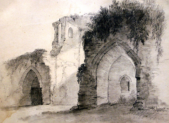
Documentary evidence and historic topographical viewsAmong the documents published by Hudson and Tingey are transcriptions of the Treasures' Accounts for the years between 1384 and 1445. These include a payment made to one John Ermswell in 1385 or 1386 'for making the ditch between the great Tower and Berstrete Gates, 2s.' This amount suggests relatively minor work, possibly cleaning out rather than digging anew the ditch. At the same time and recorded in the same accounts, 35s. 9d was spent on the ditch further down Carrow Hill at 'Conesford' Gates and 28s was spent on the ditch at Barreyates. [Hudson and Tingey, 1910 Volume II, page 48] About 1711, Kirkpatrick described the tower as having a semicircular plan. [quoted in Collins in 1910] In 1827 the Norfolk Annals recorded that on March 19th 'A large portion of the city wall at Richmond Hill Gardens, Norwich, fell into the Bracondale Rd, from the effects of a violent gale of the 17th' [Annals, vol. I, page 266] A pencil and wash drawing by L. Gurney's of 'Bracondale Tower' dated 1805 [NCM 1922.135.FAW 52:INT] is actually a view of the Black Tower from the north. However, a view by Henry Ninham [Norwich Castle Museum 1951.235.1190.B52:F] depicts the Bracondale tower from the south or outer side. The top of the tower was much decayed at that stage but there is an indication of tiles or bricks that implies that the crenellations survived at least in part and the tower as shown was almost its full original height. The wall north of the tower is shown as being lower than the tower and the crenellations were intact and follow the form surviving still on the wall further north, immediately east of the site of Ber Street Gate. The wall to the south of the tower was, by that stage, lower and an opening had been broken through with a broad, shallow-arched, brick head but was closed by a wooden gate. The tower had large windows or openings broken through on both levels on the outer side. Putlogs are clearly shown and the poor state of the wall and tower is indicated with areas of flint breaking away and a large buttress obviously added at the end of the wall. The tower of the church of St John de Sepulchre is shown above cottages on the far left of the view. A second view in the Castle by Henry Ninham [NWHCM:1929.89.39:F] is identified as 'City Walls, Richmond Hill Gardens' and would appear to be a view of this tower from inside the walls. [2] The tower is shown as open on the inner side and with the remains of arches of the wall walk arcade on both sides. On the left or south side of the tower at the lower level is shown a loop that would have looked down the outer face of the wall. Above is what looks like the surviving part of a door jamb from the way from the first floor of the tower onto the wall walk to the south leading to the Black Tower. An inscription on the drawing by the artist reads as follows:
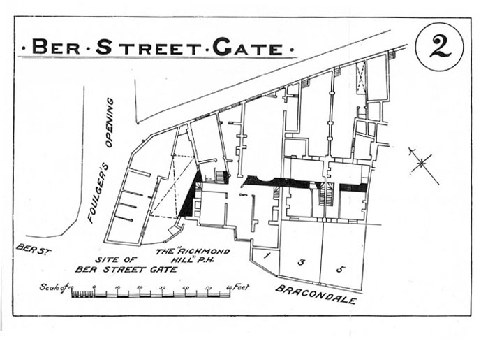
A further drawing in the Castle Museum [NWHCM 1951.235.1190.B51:F] is identified as a 'Door in the City Wall, Bracondale.' This has an arched head and jambs in stone with a finely laid relieving arch in brick. It is possible that this was the door into the tower on the inner side of the tower. However, its identification as being part of the wall at Bracondale is thrown into some doubt as two other drawings by Ninham of an identical doorway [1894.76.1054:F and 1951.235.1190.B14:F] are identified as being in Chapelfield. Map evidenceCleer's map of 1696, Hoyle's map of 1728 and King's map of 1766 all show the intermediate tower and the wall standing to their full height with crenellations. Hochstetter in 1789 shows clearly the lost tower as circular and standing at what is now the junction of Bracondale and Carrow Hill. At that date the road running out from Ber Street Gate swung slightly to the south at this point and Carrow Hill was not a road but, presumably, just a dry ditch with a footpath cutting down to King Street. The road appears to have been cut through in 1817. Hochstetter shows the ditch from Ber Street Gate to the lost tower as having been filled in and laid out with gardens. Hochstetter also shows a narrow spur of Bracondale Road running straight up to the wall immediately to the east of the lost tower. As this is the point where the view by Gurney of the exterior of the tower shows a gateway, it seems likely that the gate provided public access into the Wilderness Gardens. [for more information on the gardens see Report 32] The first edition of the Ordnance Survey map in 1885 marks the line of the wall and implies that at that stage no remains of this section of the wall or the lost tower were visible above ground. However, the map published by Collins with his report of 1910 marks the remains of the tower on the south side of the large house immediately south of Southgate Lane. He also indicates surviving sections of the wall in the backs of the houses at numbers 1, 3 and 5 Bracondale. [3] General description As part of an arch of the wall walk arcade survives on the first section of this wall in the gardens at Richmond Hill and the arcade survives in the section to the south at Carrow Hill, it is reasonable to assume that the whole of this lost section of wall had an arcade on the inner side. Without specific evidence from archaeological excavations it is difficult to say if the arches would have been a primary feature or a secondary alteration. However, as the evidence at Carrow Hill suggests strongly that the arches there are an original feature it is reasonable to assume that the lost section of the wall too had arches for the full length from the start. Map evidence implies that the lost tower was circular although Kirkpatrick describes it as semicircular. Collins describes the base of the tower as being recently uncovered in 1910. The remains were incorporated into a pathway and 'about fifteen feet of the original circumference' survived. [Collins 1910 page 29] Present State: archaeology. conservation and potential excavations Part of the wall may survive within the houses on Bracondale which appear to have been built against the outer face of the wall and over the line of the ditch. [4 & 5] As all these houses now also have extensions and gardens on the inner side of the wall it is obvious that much of the wall, if it survives at all, would have been cut away to create doorways between the front and the back parts. The lower part of the intermediate tower presumably survives under the garden or under the conservatory of number 11 Bracondale, south of Southgate Lane. The wall may survive under the garden of the adjoining property, Highbrow 11a Bracondale. [31-01 Map] BIBLIOGRAPHY:Collins, Arthur E., The Walls of Norwich (City and County of Norwich,
Norwich: Jarrold & Sons, 1910) DOCUMENTARY REFERENCES:HISTORIC VIEWS AND MAPS IN THE DATABASE:Gurney, L., 'Bracondale Tower', NCM 1922.135.FAW 52:INT |