City walls survey
35 Conisford Gate
|
|
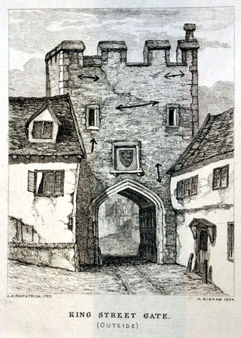
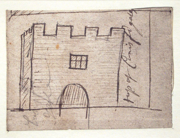
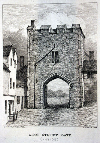
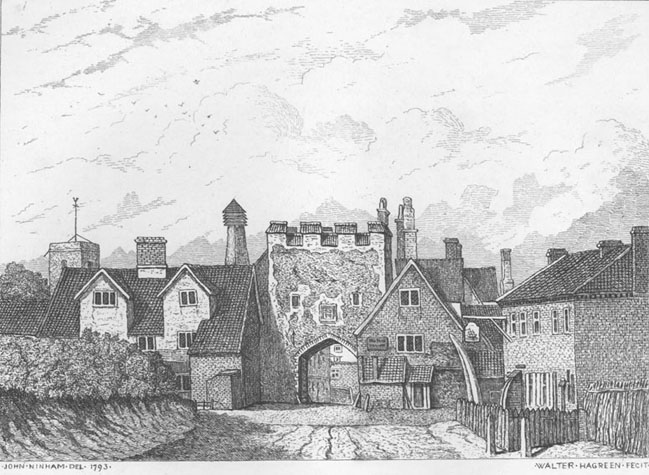
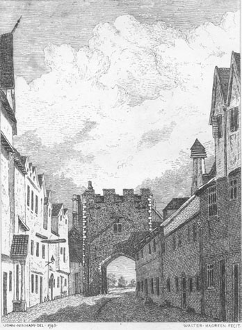
General descriptionJohn Kirkpatrick's pen and ink sketch of the top of the gate, drawn about 1720, shows four battlements to the front, and three along the side to the left of the gate. [NCM Fitch Collection 1894.76.1697, 16x22] There is one small window to the inner face and a small rounded arch is shown immediately below it. [2] Engravings of the gate by Henry Ninham in 1864 [1] copy Kirkpatrick's depiction of the gate in 1720. [NCM Todd Collection vol. II, box 5, page 116] The views show a compact solid gateway with a relatively narrow archway that appears to be constructed in stone. On the outer side, immediately above the apex of the arch, was a square coat of arms and the first-floor chamber over the gateway was lit by two small, widely spaced square-headed loops. Abutting to the left or west of the gate along the outside line of the wall and built against it was a dilapidated house, and to the right there was a two-storey, timber-framed and jettied cottage running along the street but apparently with its north gable hard against the wall. The flanking walls are not visible. The comparable view of the gate from inside the city shows a two-light, square-headed mullion window to the upper chamber. [3] A rainwater pipe emerging from the wall immediately above the window suggests that the roof of the tower was set low behind high parapets. A low building abutting the gate at right angles to the east obscures the wall running down towards the river but there is the suggestion of a sloping roof or parapet wall for the steps down from the chamber on to the wall walk. To the west the house visible on the outer view appears to be built against and over the wall. John Ninham's depiction of the south or outside of the gate in 1792 [published by Fitch in 1861] shows the cottages on either side, that to the west or left having tall dormer windows and a distinctive outshut to the front on the street side. [4] Against the west side of the gate is a slope that is almost certainly a steep parapet protecting the steps leading down from the gate chamber to the wall walk. The view from inside the city [5] shows a gate with four metal braces, three at the top, and one down the left-hand side. [NCM Fitch Collection, 1758.76.94] The archway appears to be formed in brick and there are stone quoins at the north-west and north-east angles of the gate. Buildings abut the gateway to the left and right, and again the walls flanking the gate are not visible. Documentary evidence The gates were first mentioned between 1175 and 1186 in the Liber Albus, and the Register of St. Benet of Holme, respectively. In the latter the gates were mentioned as 'ecclesiam Sancti Petri in Cuninesford prope portem civitatis Norwici.' [SMR NF26131, citing St. Benet of Holme] Documents indicate that the Conisford Gate was rebuilt and presumably reinforced in the 14th century under the auspices of Richard Spynk. [Extract from The Old Free Book, Hudson & Tingey, vol. II, pages 216-22] The Agistment for the Walls of 1451 and 1481 show that South Conesford ward was responsible for repairs to this gate. [Liber Albus, f. 177; Hudson & Tingey, vol. II, pages 313-5] The Treasurer's Accounts for 1385-6 record that 35s 9d was spent 'making the ditch at Conesford Gates'. [Hudson & Tingey, vol. II, page 48] In 1643 the gates were rampired with earth as a precaution during the civil war. [Blomefield, page 386] In 1664 part of the gate collapsed, as the house of one Isaac Wynn was ruined on account of its fall. [Fitch, page 4] The gate was presumably rebuilt or repaired as it was finally pulled down in 1794. [Fitch, page 4] An advertisement in the Norfolk Chronicle in March that year asks for people to contract to undertake its removal. [cited in full in Fitch, page 4] Map evidence Historic maps provide clear evidence for the precise position of the gate and also provide clues to the overall size of the gate. The map by Hochstetter published in 1789, just before the gate was demolished, shows the gate and the walls and buildings on either side. The map shows that the gate was set back with the front face almost in line with the walls. Most of the other gates around the city project forward beyond the wall line, being at least to some extent, built over the ditch. The first edition of the Ordnance Survey map published in 1885 [Sheet LXIII.15.15] not only shows how narrow the street was but shows that the buildings drawn by Ninham nearly a hundred years earlier were still standing. Together, the evidence from the maps and the view by Ninham fix the position of the lost gate accurately. [6] The flint walls on either side of King Street survive right up to the edge of the pavements. [35-01 Map] The space here now seems very narrow .. the surviving sections of the walls are just 11 metres apart. However, the 1885 map shows that the street was even narrower at that stage. The implication is that the whole gate, not just the archway of the gate, was about the same width as the modern tarmac road excluding the pavements. The gate was about 8 metres wide and 11 metres high and the archway was less than 4 metres wide and 3 metres high to the springing of the arch which was about 4.5 metres high to the apex. As a comparison... the tower at Bull Close Road is 6.5 metres wide and 8 metres high though it has lost its parapet. Present state: archaeology. conservation and potential excavations There is very heavy traffic through this part of King Street, using the Carrow Bridge and there would be, almost certainly, no chance of conducting an excavation on this site. [7 & 8] Contractors for any trench work in the immediate area for services should be aware of how sensitive and important this site is. Archaeological evidence could fix the position and dimensions of the gate precisely. More important, foundations and earthworks might not only determine the date of the earliest gate on this site but might disentangle a series of alterations that culminated with the gate as drawn by Ninham. Evidence from excavations elsewhere, suggest that the lower parts of the structure of the gate and the ditch and any bridge over the ditch can survive. This is, in part, because the foundations are built deep down into the ditch and because the modern ground level is, in many areas considerably higher than the medieval level providing an element of protection. If the Boom Towers and the Black Tower are to be promoted as tourist attractions then some form of information panel or at least an identification sign for the site of the gate is recommended. BIBLIOGRAPHY:Blomefield, Francis, An Essay Towards the Topographical History of the DOCUMENTARY REFERENCES:N.R.O. MF/RO 29/3 f. 177 (Liber Albus) ARCHAEOLOGICAL REPORTS:SMR NF26131 HISTORIC ILLUSTRATIONS:In the Norwich Castle Museum and Art Gallery: |