|
|
Conservation Plan
The present setting:
Generally good. The wall is completely
contained within the Jarrolds factory. There is no public access although
the wall can be glimpsed from Barrack Road through the glass corridor that runs
across the line of the wall linking two parts of the factory. It can also
be seen from the public walkway along the south bank of the river.
The area around the wall is quite tightly
surrounded by industrial buildings forming an almost-enclosed courtyard.
The area is grassed and is well maintained with a good arrangement of shrubs and
decorative trees.
Potential medium or long-term improvements recommended for the surroundings:
None can be envisaged.
Archaeological impact assessment:
The section of wall is not under any perceived
threat though in the medium to long term the factory on both sides may be
rebuilt or redeveloped. The surviving wall is clearly on the original
alignment and there were no other towers between the river and Pockthorpe Gate.
However, any work for services should be carefully monitored. Several key
questions still need to be resolved.
- Is there any evidence for an earlier bank beneath the flint wall? Almost
certainly not but that needs to be assessed.
- How wide and how deep was the outer ditch?
- How far down the side of the ditch did the outer face of the wall go?
- How wide and at what level was the lane inside the wall?
- Was the lane cobbled at any stage?
- Was the wall built out over reclaimed land if the river was wider in the
11th or 12th century?
- Were the tower and wall built in the same campaign of work?
Conservation Report Summary with Recommendations for Action
1. Immediate attention
- Replace areas of broken and lost flints at a low level at the north end
- Moderately large area of core work 5 metres north of the gateway on the
east or outer side is crumbling away
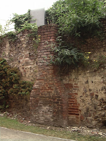
- The face of the wall on either side of the brick stack on the east side should
be repaired
2. Requires regular monitoring
- Top of wall at the north part
3. Long term conservation
- No major work required as long as repairs are made as soon as areas of mortar
deteriorate enough to let water penetrate.
4. Improvements to the setting
Long term
- Ensure that trees and bushes planted close to the wall have not grown so much
that they threaten to not only damage but also completely obscure the surviving
wall.
BIBLIOGRAPHY:
Arthur E Collins, Report of the City Committee as to the City Wall, March
1910 (pages 54 and 75)
Blomefield, Francis, An Essay Towards the Topographical History of the
County of Norfolk, vol. III: The History and County of Norwich Part I (London:
W. Bulmer, 1806)
Blyth, G.K., The Norwich Guide and Directory (London: R. Hastings; Norwich:
Josiah Fletcher, 1842)
Hudson, William, and Tingey, John C., The Records of the City of Norwich,
vol. II (Norwich & London: Jarrold & Sons, 1910)
See also:
Department of Environment Report BA/DMP/T321/768, in Gressen Hall File 384
Hudson, William, and Tingey, John C., The Records of the City of Norwich,
vol. II (Norwich & London: Jarrold & Sons, 1910), pp. 216-22, Extract
from The Old Free Book
DOCUMENTARY REFERENCES:
N.R.O. MF/RO 29/3 f. 177 (Liber Albus)
ARCHAEOLOGICAL REPORTS:
SMR NF178
SMR NF737
SMR NF388
SMR NF779
SMR NF819
|