City walls survey
1 River Lane
|
|
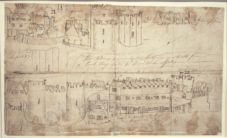
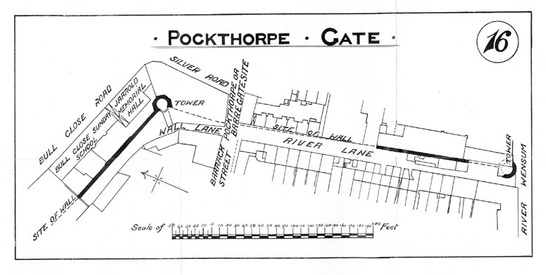
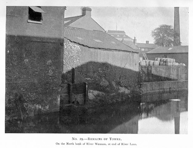
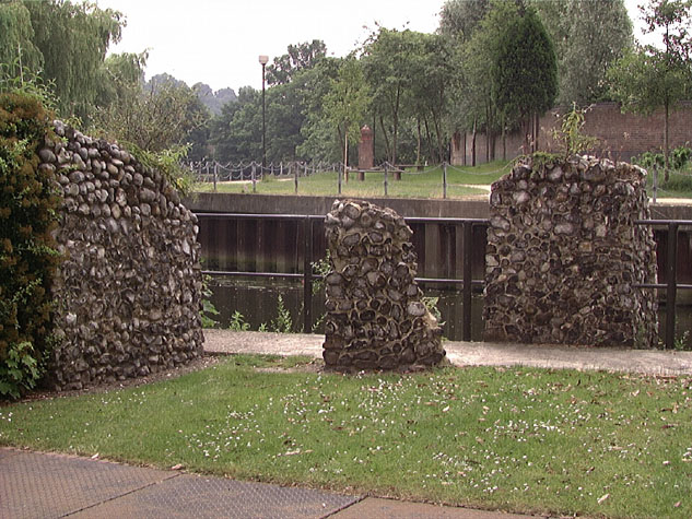
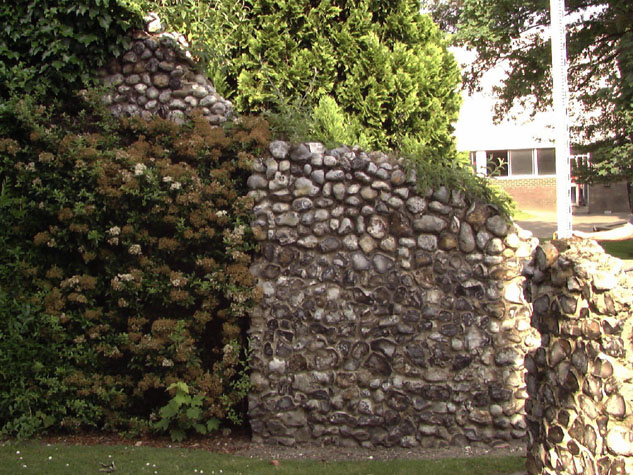
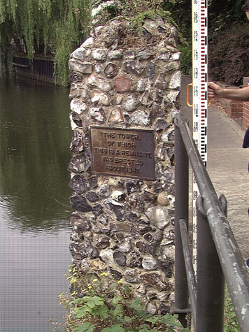
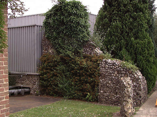
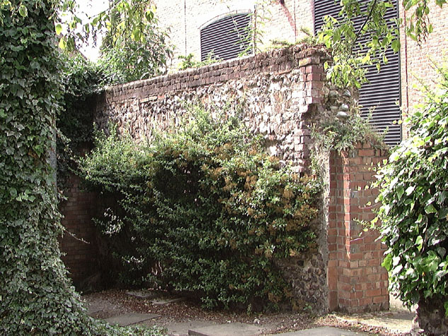
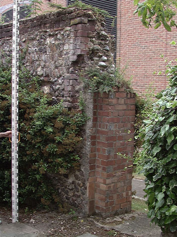
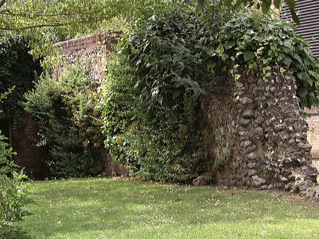
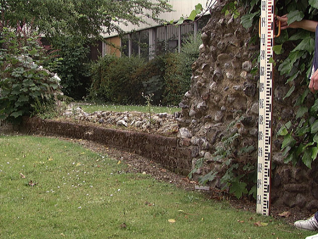
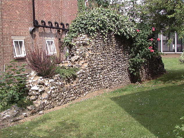
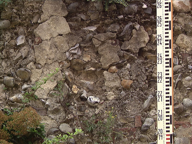
Historical Background ReportSummaryDocumentary evidence suggests that the flint wall at River Lane was the last section of the city walls to be built with work still in progress in the 1340s. Presumably this delay, in part, reflected the disputes between the Prior and the citizens of Norwich as the north-eastwards expansion of the city boundary encroached over land at Pockthorpe owned by the Abbey. None of the surviving documents refer to the tower on the river bank and it is still unclear if the wall and tower were built at the same time. Although they are probably contemporary, the tower could pre date or post date the wall. From documentary evidence and from historic maps It would appear that the tower was circular matching the Boom Towers and the towers at Oak Street and above Heigham Gate where the walls there terminated on the river bank. There is no structural or documentary evidence to indicate how high the tower was it may have been the same height as the walls with just a lower chamber like many of the other intermediate towers or it may have had an upper chamber. Nor is there evidence to indicate that there was ever an arcade on the inner side of the wall to support a wider wall walk. It may be significant that neither the wall down to the tower on the river bank at Oak Street [Report 13] nor the wall running down to the west Boom Tower at King Street [Report 36] had inner arcades. Even without the arcade, there would have been a narrow wall walk with a high parapet on the outer side. Access to the wall walk was probably from the upper chamber of the gate. The gate appears to have had a staircase on the south side abutting the lost north part of this section of the wall. The section certainly had battlements with widely spaced embrasures. Documents record that there were 40 merlons in a length of just over 105 metres. Surviving merlons at Ber Street and Carrow Hill are also about 2 metres wide with embrasures about 300mm wide and with intermediate loops in the centre of each merlon. Documents also show the importance of the lane inside the wall. The city authorities specifically acquired land to create a clear way down to the river from Pockthorpe Gate. Again there were similar lanes down to the river on the inner side of the wall west of Oak Street and on the inner side of the wall below King Street. The lane may have been seen as an important clear way for moving troops but more probably there was a deliberate attempt to keep buildings back from the inner face of the wall. Presumably roofs of buildings against the wall would have been vulnerable to incendiary attacks from outside and buildings against the walls may well have been seen as a potential means for smuggling people or goods in or out of the city when the gates were closed. General description of the historic fabric The standing fabric of the wall is essentially medieval for original putlog holes lined with bricks survive in several areas. However, only core work survives and that much re-pointed and refaced. The face flints were lost when buildings constructed against the wall on both sides in the 18th and 19th centuries were demolished. The present ground level may be somewhat higher than the medieval level but none of the descriptions of work undertaken around the walls in recent years suggests that there is any buried evidence for arches. There appears to be nothing in the way that the wall is constructed to distinguish it from other earlier sections of the wall elsewhere. Documentary evidence:Work on the gate itself was, presumably, in progress in 1338 for a document of that year records that William de Claxtone, Prior of Norwich, gave one great plank to 'Barrechate' which cost 4s. and gave 40d. and 12d. to the workmen there. [Comp. Cam.] If the gateway was still not completed, this would explain why in 1342 Pockthorpe was not one of the gates that was armed with 'espringolds' paid for by Richard Spynk. In 1344/45 John, son of Robert de Kirkeby, granted and sold to the city one piece of land out of his close in St James' parish at Barregates. This land lay between the land of the Communality to the east and his land to the west containing in breadth 14 feet and in length as much as his said close extended. [Civ. Dom. Quoted by Fitch] This land may have been on the north side of Pockthorpe Gate. However, on the Feast of St Mark (25th April) in 1346 Richard de Lyng, parson of Redham, John de Berneye and John Chenele granted a piece of their land at Le Barregates for the wall and lane there. The land stretched from the King's way to the King's river called Wensum. [Dom. Civ.] Presumably, this land was required to complete the building of the wall from the south side of the gate to a tower on the bank of the river. A Customs' Book dating from the 14th century, from the reign of Edward III, records the number of battlements in the circuit of the defenses. The wall and towers north of the gate, between Pockthorpe Gate and Magdalen Gate, had 178 battlements, Pockthorpe Gate had 10 battlements and the wall and tower to the south of the gate about 40 battlements.[Fitch page x] Again, this list was presumably compiled to help decide what repairs were required and to determine who was responsible for the work. In the 15th century there were further disputes about the responsibility for repairs to each section and in 1451 an Agistamentum or distribution of the burden of repairs was issued. Fibrig ward was responsible for Fibrig (Magdalen) Gates 'with al the walles and toures unto the next tour on the north side of Barre Gates.' East Wymer Ward on the south side of the river 'shall have the said toure and Barre (Pockthorpe) Gates, and alle the walles unto the toure in the water, and the same toure; with the dongeone by ye Hospitall Meadowes on the north est corner.' [Fitch page xvii and The Agistment for the Walls, 1451, 1481, Liber Albus, f. 177; Hudson & Tingey, vol. II, pages 313-5] Blyth's 1842 Directory of Norwich mentions that the wall here `extends to the river side, where it finishes with a round tower.' [Blyth, page 5] Map evidence:Although Cunningham's map of 1558 shows the wall between Pockthorpe Gate and the river, he does not show the tower on the river bank. By the mid 16th century there were houses on both sides of what is now Barrack Street inside the walls and on both sides of the road outside the gate. However no buildings encroached on the wall. Kirkpatrick in the early 18th century also shows the wall free of buildings. He shows a round tower on the river bank and appears to show the outer ditch still with water in it for he draws a stream running away from the ditch just south of the gate ran parallel to the river before it joined the main channel on the outside of the bend opposite Cow Tower. Cleer, on his map of 1696 also marks the stream and the tower. Perhaps the stream suggests that the low lying land was potentially wet or waterlogged. Certainly if the river was wider in the 14th century, marshy land here beyond the ditch would have provided additional defence to this section of the wall. None of the 18th-century maps, including those by Hoyle, Blomfield and King show the tower though they all mark the wall surviving for the full length between Pockthorpe Gate and the river. Hochstetter in 1789 showed a large courtyard house built against the outside of the wall immediately south of the gate. Clearly the ditch and stream had been filled in by then although a number of narrow channels are shown draining the gardens along the north bank of the river beyond the wall. Hochstetter also shows two long narrow buildings against the inside of the wall at the south end, over the line of the inner lane. The brick fireplace and chimney of the building furthest from the river survive. Both buildings are shown on the first edition of the Ordnance Survey map of 1885 [sheet LXIII.11.9] but by then there were houses against the whole of the outer side of the wall. The north end of the wall had been demolished and only the surviving section is shown as still standing in 1885. The tower on the river bank is marked and is shown as being built into the south gable of the building on the inner side of the wall. River Lane is marked on that map as Water Lane. Historic views and historic photographs:A sketch of the walls around Pockthorpe Gate drawn by John Kirkpatrick about 1720 and now in the Castle Museum, may include a depiction of the tower on the river bank. The drawing has a number of vignettes of different towers from several different directions. One is labelled as the first tower and a separate tower, clearly polygonal is presumably the surviving tower at Bull Close Road. [Norwich Castle Museum and Art Gallery 1894.76.1746:F] [2] There appear to be no other historic topographical views of the tower or this section of the wall. The 1910 report by Collins includes a photograph of the tower taken from the river but it is dominated by the industrial buildings running down to the river bank and it is difficult to distinguish which parts of the flint wall that can be seen, belong to the tower. The sketch plan with the report shows a much more substantial part of the tower standing with an arc of wall on the south-west side. It may have stood to almost its full height as the flint work on the photograph appears to rise to the level of the eaves of the adjoining building. [3 & 4] [Collins, 1910 photograph 29 and map 16] Archaeological reports:The site has been of recent archaeological interest and is mentioned several times in the Sites and Monuments Record (hereafter SMR). SMR site name NF736 shows an Elizabethan coin found in a small garden by the city wall in 1983, while site name NF178 mentions a modern shed built along the west side of the medieval city wall. In 1987 a trial excavation undertaken by the Norfolk Archaeology Unit for Anglian Water revealed that parts of a turret next the River Wensum (23563 09305), and visible above ground, were of modern construction. However, they overlay the remains of a turret with an entrance doorway dressed in brick with a brick-on-edge threshold (SMR779). Also revealed was the constant refacing of the city wall, which has given a false impression that the wall steps inward, when excavation shows it continues in a straight line (23563 09307). The wall extends to a depth of about 2.3 metres at a point 20 metres north of the river (23553 09340). Apparently a secondary file exists detailing these finds, but it could not be located at the NAU or at Gressen Hall at the time of search. In 1988 digging by Eastern Electricity for a cable trench, running south of the footpath approaching River Lane, cut the line of the city wall 3.25 metres south of the south curb edge. This revealed that the top of the wall was only 5cm below the surface of the tarmac. The interior (west face) was visible, and dressed with facing flints, while the exterior (east face) was obscured by later abutting brickwork. The width of the wall was found to be 1.20 metres, with 60cm depth visible. The bonding agent was found to be lime mortar. Approximately 60cm of wall depth and 80cm length was destroyed for the cable duct (SMR NF819). Apparently plans for the location of the wall are kept in the associated River Lane File, but this was not located at the NAU, nor at Gressen Hall at the time of search.Condition SurveyThere are four wedges or chunks of flint wall on the river bank forming the north part of the curve of the tower. [5] These are cut through by the pathway of a river-side walk running east west. The surviving wall runs back from here for 50 metres. The tallest section close to the tower is 4.5 metres high but much of the rest is much lower some parts being little more than 300mm high. Essentially, there are five sections to the wall [external and internal elevations 01-03 & 01-04]. The first part is the 'remains' of the tower itself. These stand on the embankment about 1.25 metres above the level of the river. The three detached blocks are of irregular shapes but basically wedges none more than 1.8 metres high. [6 & 7] They form a curve representing the north side of the tower. A pathway runs between the blocks but generally they are in a good state of repair and not threatened by the relatively small number of people that must use the path. The flint work all looks modern. It is difficult to be certain what is being measured but if the flintwork above ground does respect the original plan of the tower at a lower level, then the tower was 6.3 metres across and had an internal diameter of 4 metres. [south elevation of the tower 01-05] The fourth part of the tower is an integral part of the first section of the wall. [8] This is just over 5 metres long and is the highest part of the surviving wall being over 4.5 metres. The wall has been almost completely rebuilt and is ostensibly brick faced on the east or outer side. The brickwork is mainly headers interspersed with flints though there is a string or band of modern brick across the upper part presumably to strengthen or consolidate the wall. The inner or west side is almost completely covered with undergrowth though one putlog survives at an upper level and the position of this lines up with putlogs further along the wall. Most of the flints here are cobbles rather than knapped flints which generally around the walls indicates an area of repair. Ivy over the wall should be removed and dense bushes on the east side thinned out. Vegetation on the top of the wall should be removed and any hollows or areas of missing flints should be repaired or replaced. Soft mortar on the top should be replaced with a soft lime mortar laid to encourage water to run off. The third section of the wall has been completely rebuilt mainly with cobbles and forms a low retaining wall for a clad industrial building against the east side that sits on the wall. This was said to have been built in 1972. The fourth section is much more substantial and is distinguished by incorporating the remains of a fireplace and chimney stack built against the wall when a building was constructed against the west side of the wall in the late 18th-century. The wall here is in a very poor state with large areas of mortar on either side of the stack that are just interspersed with flints and bricks. The area is de-laminating and some immediate repairs are required. The upper part of the wall has more regular courses of brick that form a copping. High buildings around provide some shelter from wind-driven rain but this section is still very vulnerable to damage from water penetrating the exposed core. Self-seeded buddleia on top of this section should be removed and the top of the wall consolidated. At the north end of the part there is a narrow gateway or doorway with a brick jamb on the south side. [9 & 10] This too is a surviving part of the 18th and 19th-century buildings constructed against the wall. Bricks on the east side at the jop of the pier have collapsed and this should be rebuilt. The last and longest section is heavily overgrown. [11] It drops down in the centre to almost ground level with brick on the west side. [12] It rises up again to just under 3 metres high before stepping down again and tailing out at a point 50 metres from the river. On the west side are vertical piers of brick work that are stitched into the flint and are presumably reinforcements possibly where cross walls of the later buildings were demolished. The east side of the wall is all exposed core work. Though generally well pointed some large areas are breaking away. [13 & 14] The wall here is at most 790mm thick the wall excavated to the north, close to the site of the gate, was 1.2 metres thick and the archaeological excavation reports suggest that the buried parts are even more substantial. Possibly 200mm of facing flint on both sides has been lost. The top of the wall is very irregular and water penetration is a serious problem. Curiously, the dense undergrowth of ivy climbing over the wall may provide a level of protection. In some areas a hard cement mortar has been used. In any repairs this should be replaced with a softer lime mortar. The low north end is breaking apart and should be rebuilt reusing the bricks and flints. [15 & 16] List of known repairs:It is not clear how much repair work was undertaken in 1972 or 1987. Summary of present condition:Some areas of the flint work are in a very poor condition particularly at a low level at the very north end where flints are breaking away, along the top of the north section which is very irregular and around the chimney stack on the west side. Principal conservation problems:There are no serious problems with this section of wall although it should be monitored annually and areas of loose core work re-pointed. There are three general problems:
Deterioration of the brickworkSeveral areas of the wall have been refaced with a thick buttering of mortar with random coursing of reused and widely spaced bricks and flints. This is presumably material from the demolished buildings against the walls reused to consolidate and repair the standing wall. If areas are repaired then the bricks should not be reused. On the west side the piers of brick are now an archaeological feature telling part of the history of the wall and should be retained |