|
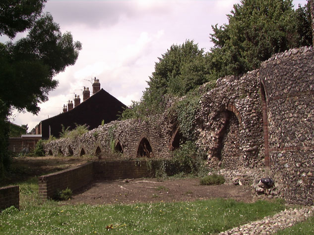
[4]The inner face of the wall from the south east with the surviving arches.
[32] View of the wall and tower from the south west showing the extent
covered by annual growth.
|
Conservation Plan
The present setting:
Immediately around the tower itself, on the north,
east and south sides, there are public gardens with a mix of mature trees, low
planting and grass that provide a relatively attractive and appropriate setting
for the surviving historic structure. On the north side of the wall there is a
long narrow car park with a single entrance from Bull Close Road at the west
end. The area on the south side of the wall is not well maintained. [32]
Here there was a large electricity sub station, though this has been reduced in
size and now only occupies the west end of the area. The rest of the area
against the wall is a mixture of rough grass and self-seeded shrubs and plants.
On the east side of the tower a tarmac footpath
cuts diagonally across the public garden. This runs from the north-east
corner of the gardens, at the corner of Silver Road and Bull Close Road, to the
pedestrian crossing for Barrack Street just to the west of the roundabout at the
junction of Barrack Street and Silver Road. This is a popular and well
used pedestrian route to the city and this with the open aspect of the gardens
presumably helps to reduce vandalism.
There is an area of planting along the Silver Road
footpath to the east of the tower, with four young trees and a low retaining
wall, and well-spaced planting of mature trees north of the wall, along the
south pavement of Bull Close Road. This planting provides an attractive setting
for the wall without blocking sight lines and views of the tower. These
trees are a mixed planting of Sorbus aria and Tilia. All the trees are
healthy and should have a reasonable life span. They provide an
appropriate backdrop for the wall and this area would feel exposed and open
without the green foliage. The height of the canopy should be monitored
and lower branches removed if necessary to maintain the sight lines to the wall.
After the survey was completed, the paving along
Bull Close Road was replaced with a mixture of brick sets and open areas around
the trees filled with bark. The landscape architect on this project
approved of the design, which allowed plenty of space for the roots of the trees
not only to absorb water but to grow and expand without raising the paving.
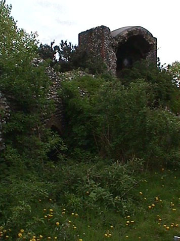
The dense planting of Garrya elyptica on the north
side of the tower has grown to a height of about 4 metres and causes a problem
by creating an enclosed area where the surviving wall abuts the tower.
This collects rubbish and attracts children who use the area as a den.
From the nature of some of the rubbish, it also attracts itinerants and homeless
people who appear to use it as an overnight squat. One local man reported
seeing rats around this area which indicates the seriousness of the problem.
This debris is not in itself harmful to the
historic structure but the general state of this area certainly encourages some
people to dump further rubbish here. The simple solution would be to
remove just the large shrub immediately against the tower and replant that area
with either grass or possibly tough low evergreen planting such as cotoneaster
horizontalis if it is necessary to stop people using this as a cut through. The
Garrya elyptica further from the tower and closer to the road should be retained
as they screen the car park but the canopy should be raised by cutting back the
lower branches. This should stop the collection of rubbish. The
Garrya could be under planted with low ground cover.
The car park is used by local people and parking
is controlled so the number of cars here is not excessive. Car parking
bays for 15 cars are marked out along the north side that is along the road
side rather than against the wall. A narrow footpath with a high kerb
directly against the wall to some extent protects the flint work from damage as
cars manoeuvre and reverse. This does not create the most attractive
setting for the wall but it is not detrimental to the structure and has the
advantage of low maintenance costs.
On the south side of the wall access to the sub
station was by a short curved lane approached from Barrack Street which is on
the line of the former Wall Lane. This access is closed by a low metal
barrier-style gate.
Immediately by the tower is a low brick retaining
wall, part of the garden landscape to the east, but a tree here has caused the
grass to die and there is now a large ugly area of mud around the stump of the
tree where it was cut back. The stump should be removed and the area
re-seeded.
Beyond the retaining wall, along the whole of the
45 metres of the surviving medieval wall, is an area of rough grass and self
seeded shrubs and bushes. [4] The strip of
land is about 7 metres wide with a low retaining wall along the south side and a
drop down to the gardens of a 1930s block of flats that stands between the wall
and Barrack Street. There is a chain link fence along this boundary and a
number of small trees and bushes.
At the west end, the remaining equipment from the
sub station is set behind a poorly-maintained link fence. On the west side
of this there is a high modern brick wall that forms the boundary of the back
entrance to the flats. This wall has a narrow gateway at its north end
which, at the moment, provides access to the equipment of the substation.
There is no official way through here for pedestrians. This has some
advantages.
None of this is actually detrimental to the
preservation of the structure of the wall. However, the undergrowth grows
quickly and within a single season can completely swamp the wall. If the
area was grassed over properly it might discourage people from dumping rubbish
and creating a path through, might integrate the area south of the wall with the
garden and with the houses further along Bull Close Road. Any changes
could only be undertaken after consultation with residents in the flats.
Potential medium or long-term improvements recommended for the surroundings:
-
This section of the wall and the tower are not in the main tourist area but the
wall is generally in a good state of repair and its main features are certainly
representative of the defensive wall as a whole. Visitors might be
encouraged to come here by appropriate signs and directions or recommendations
in guide books. This is one section of the wall where an appropriate information
panel would help visitors. It could be a simple text on a robust,
low-maintenance mounting and could be positioned just south of the tower and
slightly away from the pathway.
-
To the south of the tower, the line of the wall between the tower and the site
of Pockthorpe Gate has been marked out in cobbles but this is actually much too
narrow to strictly represent the medieval wall. Few visitors would
understand either how substantial or how imposing the wall here would have been
and there is nothing to indicate that there was a wide water-filled ditch
between the tower and Silver Road. Nor is there anything to help the
visitor visualise the imposing flint gatehouse some 10 or more metres high that
would have sealed the route into the city and stood where there is now a mini
roundabout. A simple information panel would help many to appreciate more
fully what does survive.
-
An iron gate in the semicircular wall that closes the south side of the tower
means that it is possible to see into the tower. It also makes it possible
to throw rubbish in and this should be cleared away regularly. Also there
is an overpowering smell of pigeon droppings and this problem, with birds
nesting in the upper openings of the tower, should be resolved. The floor
of the tower should be cleared and possibly a wide step built in front of the
gate so people can stand and look in. However, for security and safety
reasons it is not advisable to remove the gate and give the public open access
to the tower.
-
It may be possible to allow short term parking for visitors on the car park
though this would have to be done in consultation with local residents and could
be open to abuse.
-
The area to the south of the wall would be improved if self-seeded shrubs were
removed at regular intervals before they became established. The area could be
sown with grass and a wild flower seed mix with minimum mowing at the beginning
and the end of the summer.
-
A more ambitious scheme could convert the area into a small park. As an
initial stage, the hedge on the south boundary could be improved with extra
planting and the area could be softened with low maintenance, low-level
planting. The area is surprisingly quiet, sheltered from the noise of
traffic on the inner ring road by the block of flats. People could be
encouraged to make use of the area with the installation of some robust seating
against the wall which faces south and is a sun trap. A pathway could
either be laid out with Breadon gravel or could simply be defined by close
mowing. This would essentially re-establish the line of the medieval lane
inside the wall.
-
Security and problems with vandalism could be improved by opening a way through
at the west end to encourage regular use. This could be achieved by moving
the equipment of the sub station to the south edge of its site and simply
removing the door in the brick wall to create an open arch.
-
Some low level lighting would be necessary to make the area safe in the evening.
The provision of lighting would also be an opportunity to consider the
installation of appropriate flood lighting for the tower.
See the proposal plan.
Archaeological impact assessment:
It is not within the remit of this survey to make
specific recommendations for archaeological work on the wall. The general
policy for scheduled sites is now to excavate only as a response to threat and
any excavations would have to be controlled by the County Archaeology Unit.
However, this section of the wall and the area around the tower are important
because:
-
they are well preserved
-
they represent clearly features that have not
survived as well elsewhere
-
map evidence indicates that the land to the
south of the wall, on the line of the 'way under the wall' has not been
built on and disturbed
-
excavation could answer important specific
queries about the date of construction and the original form of the tower
and wall
Although the tower and wall are close to the main
inner ring road and its heavy traffic, the area immediately around the surviving
work is unencumbered with buildings and is in public ownership. Access for
archaeological investigation would be relatively easy. If funds should be
available specific questions about the wall, the construction of the tower and
the date of these works should be considered. Archaeological investigation
might also raise the public profile of this area. In a period that is
sensitive about restraint in public spending, work such as this would have to be
carefully explained and justified but appropriate expenditure highlights the
importance and value of the site.
-
Excavations against the south side of the tower could establish the position and
form of the south or inner wall of the tower. However, the photograph
published with the 1910 survey indicates a deep ditch at the south corner of the
tower at that date that presumably cut through and disturbed or removed the
earlier layers. If the structural fault at the south-east corner of the
tower (see Condition Survey) has to be resolved by some rebuilding or
underpinning, that would be an appropriate point for some more academic
investigation.
-
The wall immediately to the west of the tower is only 20 centimetres thick and
has been much rebuilt. This was probably the site of a stair turret or
external steps giving access to the wall walk to the west and access to the
first floor of the tower itself. There is a large apron of flint work in
this corner, against the tower, that could have supported steps and its date and
depth could be established.
-
The line of the wall running from the south side of the tower, towards the site
of Pockthorpe Gate, is marked in modern cobbles. If this area was
excavated for whatever reason, it would be important to try to establish the
exact alignment of the wall and its junction with the tower should be examined,
to determine if the wall was earlier than the tower. The wall here
survived (in part) until at least 1883 when it was surveyed by Ordnance Survey
for the map published in 1887.
-
Excavation in the area to the east of the tower could also establish the line,
depth, and form of the outer ditch as it turned and headed for the river.
Excavations undertaken to the south, on the remains of the wall running south to
the site of Pockthorpe Gate, could show just how far the medieval structure
continues below the modern ground level.
-
The surviving wall to the west of the tower is about 17 metres from the modern
line of Bull Close Road. Any excavations here, either for public utilities
or specifically in academic investigation, could establish the form of the outer
ditch. Given the topography of the site, with the land rising to the west
and north, the outer ditch presumably carried considerable surface drainage as
well as forming part of the defence. It was probably not as wide or as
deep as the ditch excavated at St Benedict's Gate in the 1950s, where the
ditch was up to 30 metres wide and almost 8 metres deep, but, here, might be up
to 20 metres wide.
-
Buildings are shown against the north side of the wall in the view by Richard
Dixon of 1809. These appear to be of late 16th-century or early
17th-century date with tall gabled dormers. Although Dixon may have used
some artistic licence, buildings are marked in this position on 18th and
19th-century maps. An excavation in this area might reveal the foundations
of these buildings, could suggest the date when the ditch was back filled and
could determine the sequence of building and rebuilding on the site that
culminated with the building of Jarrold's Memorial Hall, built on the north
part of this area by the late 19th century.
-
Map evidence suggests that by the 19th century there were buildings further
along Bull Close Road with open yards between the buildings and the surviving
wall. However, patching, re-facing and alterations in the north face of
the wall itself suggest that earlier buildings encroached on the wall more
directly. Excavations on the Water Lane site to the south of Barrack
Street established that the wall was much wider there than the rebuilt visible
remains above ground suggested. At Bull Close Road, there is no certain
area of original facing flint work on the north side. Excavations in the
area of the car park would establish the line of the outer face of the wall and
therefore its original thickness.
-
The south side of the wall is still open and free of buildings. The
present ground level encroaches on the arches so it is considerably higher than
its medieval level. The form of the arcade surviving elsewhere would
suggest that the present ground level inside the wall is probably 1.8 metres
above the medieval ground level and on the north or outer side the level has
risen by at least 2.5 metres. Excavations here could reveal the natural
ground level, uncover an earlier bank, if one preceded the building of the wall
here, and determine if the brick arches along the south side were a primary
feature or if they were added.
-
Early maps of the city, including that by Cunningham of 1558, show a lane
running around the wall against the inner side. This is marked as 'the
way inside the wall'. J G Hurst in 1953 suggested that generally around
the city, this lane dates from about 1500. This area of the wall, where
there appears to have been little disturbance or building work, might provide
one area where archaeological excavations might establish a date for this lane.
Elsewhere, it appears that the inner lane may well have been raised above the
general level of the adjoining plots inside the wall. Material would have
been available from the excavation of the ditch and raising the lane immediately
against the wall would have deterred encroachment.
CONSERVATION REPORT SUMMARY WITH RECOMMENDATIONS FOR ACTION
-
Immediate attention
-
Remove the elder tree that is now well established within the tower and treat
the root
-
Repair and make good the brick arch of the gateway into the tower thrown forward
by the elder
-
Remove old root stocks on the north side of wall and make good flint work
-
Remove self seeded shrub (buddleia) on north east face of tower and shrubs along
top of wall
-
Remove root stocks of elder, buddleia and bramble along the base of the wall on
the south side
-
Kill and then remove the ivy around the 2nd arch from the east on the south side
-
Where necessary, re point and repair small areas where flints are loose
-
Requires regular monitoring
-
Monitor settlement at the south-east corner of the tower with long vertical
fissure through flint
-
Check gutter and run off of rain water from roof at least annually to ensure
that the gutter is not cracked or ponding back the water
-
Monitor any damage to lower part of tower at the south-west corner caused by run
off from the roof gutter
-
Inspect top of tower wall/parapet for loose flints and weather ingress
-
Long term conservation
-
Resolve problem of pigeons nesting in the upper openings inside the tower by
using repellents and/or netting
-
Budget for renewing capping for vault and gutter in lead
-
Repair top of wall and regularly replace flints that have been dislodged.
As a general principal repairs to the top of the wall should be with rounded
flints set into soft mortar not sharp flints bedded in hard concrete.
The problem here is caused by rain and then frosts getting into cracks around
the flints aggravated by children climbing on the walls dislodging loose flints.
-
Improvements to the setting
Priority
Long term
-
Remove tree stump to the south west of the tower and re grass this area
-
Remove the aluminum barrier across the access road on the line of
Wall Lane and replace with removable bollards if required
-
Replace the fencing on the east side of the electricity sub station at the
west end of the wall
-
Thin out hedge and replace link fence along south boundary between the wall and
the gardens of the flats to the south
-
Consider creating small park on south side of the wall with appropriate
planting, seats, a pathway and some lighting. This would extend the area
of planting east of the tower
-
If the proposal for a small park is implemented then the curved access road up
from Barrack Street should be re-laid with Breadon Gravel to match the pathway.
-
Construct appropriate and robust information panel
-
Consider low level lighting for the area south of the wall and spot light
illumination of the tower itself.
BIBLIOGRAPHY:
G K Blyth, The Norwich Guide and Directory (London:
R. Hastings; Norwich:
Josiah Fletcher, 1842)
Arthur E Collins, Report of the City Committee as to the City Wall ,
March
1910 (pages 51-54 and 74-5 Map 16 and photograph 28)
William Hudson and John C.Tingey, The Records of the City of Norwich,
vol.
II (Norwich & London: Jarrold & Sons, 1910) pages 216-22, Extract
from
The Old Free Book
DOCUMENTARY REFERENCES:
1345 Customs Book
1386 Wardens List
1512-1513 (4th Henry VIII) farm or rent of the tower
Plans from Gressen Hall file 384
NAU Watching Brief Report, Whitefriar's Drainage Trench (Gressen Hall file 384)
HISTORIC ILLUSTRATIONS IN THE DATABASE:
Kirkpatrick, John, 1716, 'The Tower and Remarkable
Buildings on the Walls
from Pockthorpe Gates to Magdalen Gates ', NCM 1894.76.1746:INT
View of tower from the north east 1809. Water colour by Robert Dixon,
Norwich Castle Museum
|