City walls survey
3 Bull Close Tower and Wall
|
|
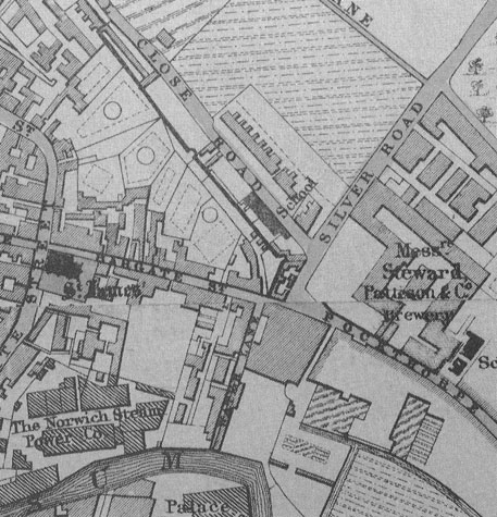
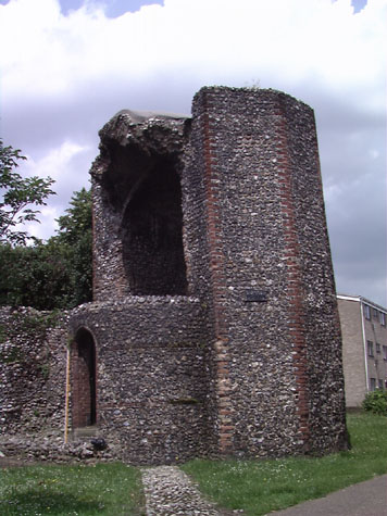
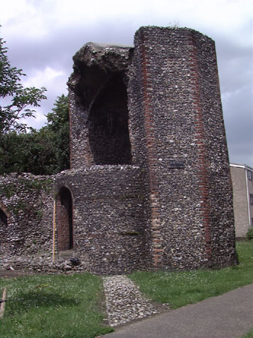
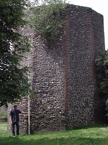
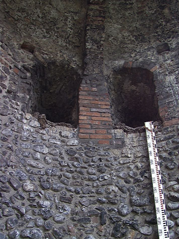
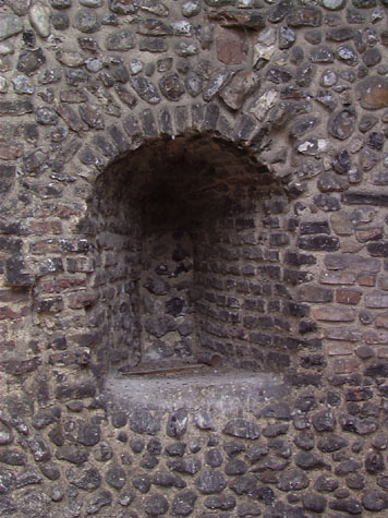
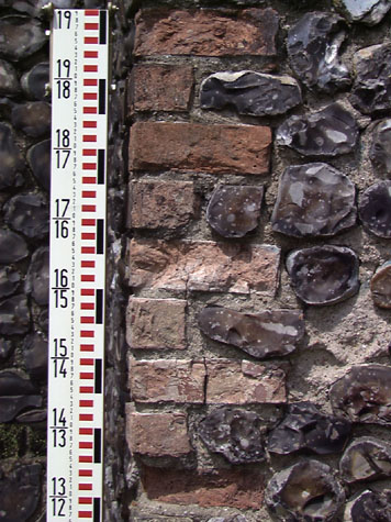
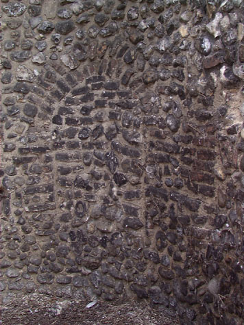
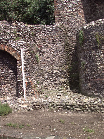
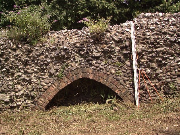
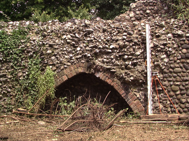
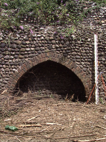
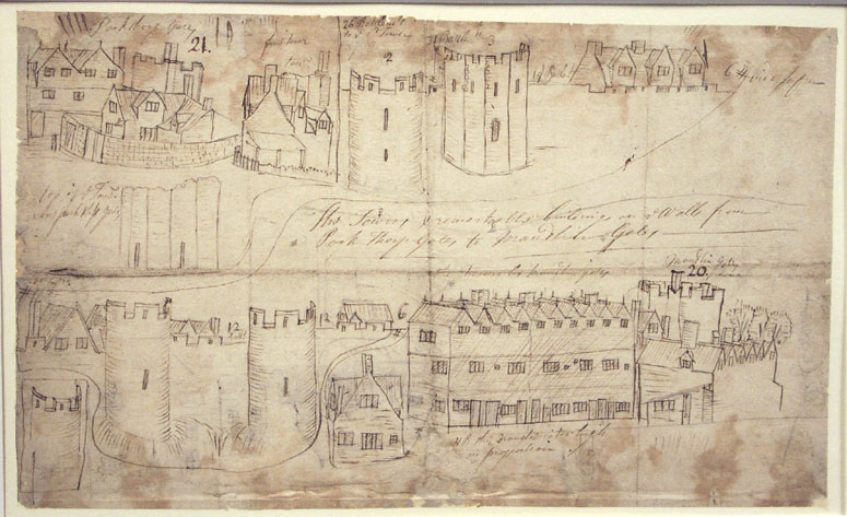
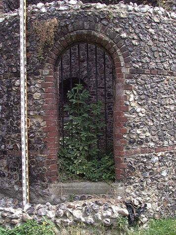
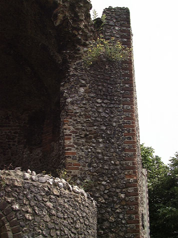
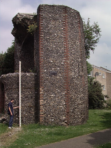
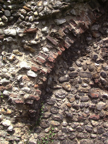
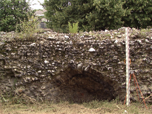
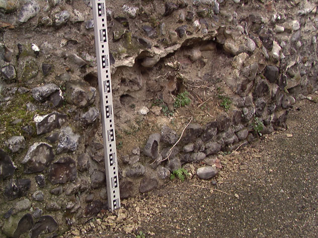
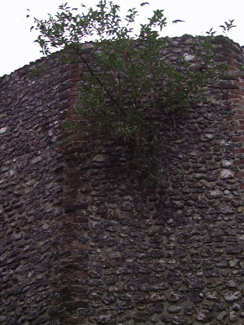
Historical Background ReportSummaryThe tower that survives at the junction of Bull Close Road and Silver Road was at the north-east corner of the defences of the medieval city and is in the parish of St James in Fybridge Ward. [map 03-01] Immediately to the south of the tower was Barre Gate, later called Pockthorpe Gate. The present line of Barrack Street is less than 15 metres south of the tower. Though wider than the medieval street, this road follows the line of the medieval road that ran from the extra mural settlement at Pockthorpe, just to the east of the gate, and entered the city through the gateway. In the 19th century, Barrack Street was known as Pockthorpe Street outside the gate and as Bargate Street to the west of the gate, inside the wall. The wall continued to the south of the gate and terminated with a tower on the bank of the river some 130 metres to the south of the Bull Close Road tower. From the Bull Close Road tower, the wall ran sharply to the north west in a long arc and continued to the next gate at Magdalen Street. Documentary evidence cited by Robert Fitch in 1861 suggests that this section of the wall may have been one of the last parts of the defence to have been built. Permission for the first murage tax in the city was granted in 1294 and work generally seems to have progressed rapidly. In this area, however, there appears to have been a dispute with the Prior of Norwich about land ownership and presumably also about the future upkeep of the wall once built. In most areas this was the responsibility of each Ward. A grant of land in 1326 and the final resolution of the dispute suggest that the tower and this section of the wall were completed about 1330. Pockthorpe Gate was still under construction in 1338 and the wall between the gate and the river was probably not finished until 1345 or 1346. It is probably significant that the document for the grant of land in 1326/7 refers to the common ditch and not to a wall suggesting that the wall had not at that stage been built. Both the use of brickwork on the angles of the tower and the plan of the tower suggest that it is later than the main building period for much of the wall. Brick was also used on Pockthorpe Gate itself and this was possibly the time that brick arches were added to the rear of the wall elsewhere around the city to support a new wall walk. Elsewhere in England polygonal towers appear to be later than circular or semicircular towers. In the City of York, the rebuilding of the defensive walls was probably complete by 1266 and most of the intermediate or 'interval' towers are circular or semicircular in plan. A study of the walls published in 1972 concluded that 'the semicircular or round tower was the normal form in England during the 13th century.' [Royal Commission on Historical Monuments, City of York Volume II The Defences 1972, page 44]. Rectangular towers in York are considered to be a later form than round towers and polygonal towers later again. The tower at Bull Close Road had two storeys and it survives to almost its full height on the north side [10] although the inner or south side, towards the city, had collapsed or was demolished before the 19th century. On the outer side, on the side facing out from the city, the tower was polygonal with eight narrow faces and these faces had brick dressings at the angles. On the inside of the tower, the wall is curved and both the ground-floor and first-floor chambers had narrow slits or loops looking out to the east, north and north west. [11 & 12] This may reflect the important position of the tower at a vantage point. Although generally, the defensive nature of the walls has been questioned, this is a vulnerable point on the circuit as, outside the wall, the ground rises steeply to the north and east with the walls here overlooked by the high ground of Mousehold Heath. General description of the historic fabric The tower is faced with knapped flints that are generally well coursed although there are several areas that have been patched or repaired, particularly on the north-west corner. The angles of the tower are strengthened with brick set alternately to left and right like quoins. [13] The ends of the bricks are rubbed to an angle to respect the corner. Although there is one line of much-worn earlier brick on the east side of the tower, most of the bricks appear to have been replaced. The later brick has a fine texture and is hard. It is significant that the same brick is used on either side of the wide opening on the south side where the wall was made good with the removal of the inner side of the tower. This work appears to be part of a major restoration of the tower, presumably at the end of the 19th century and it was certainly in place by 1909 when a photograph shows the tower in its present form. [14] Inside the tower the north wall is curved rather than polygonal. There are deep reveals with arched tops in header bricks for the narrow loops or lights with at least four openings for the ground-floor chamber and five closely spaced openings on the first floor. These are all now blocked either completely or with flints on the outer face of the wall. [15] The opening on the east side on the ground floor does not appear to be centred on one of the faces of the outside. The re-facing of the outside wall face and the complete blocking of the opening make it impossible to determine the angle of the reveals. There appears to be no obvious reason for setting this opening at an angle. [plan 03-02] At Coburg Street [Report 23], at St Stephens tower [Report 26]and at the Black Tower on Carrow Hill [Report 32], loops were set in the sides of the towers, close to the outer face of the walls on either side, to facilitate covering fire along the line of the wall. That arrangement may also have been adopted for the tower at Bull Close Road. Although the east side of the tower, close to the line of the wall running down towards Pockthorpe Gate, has gone, on the west side of the tower, on the inside, the brick arch of a loop looking along the outer side of the wall to the west survives. The floor of the upper chamber has gone but the large space between the ground-floor and first-floor windows and slight scars on the wall face indicate that originally there was a solid vault to the lower chamber. However, the quadripartite vault of the upper chamber survives with brick ribs and brick vaulting. The position and asymmetrical alignment of the ribs suggests that the upper chamber was not circular the vault appears to have continued to the south as a barrel. Circumstantial evidence from historic maps suggests that the south wall may have been straight creating an elongated D-shaped plan for the tower. There is no evidence for an internal staircase but as there was a brick vault to the lower chamber then any staircase would have been external, or within the thickness of the wall or within a stair turret. Immediately to the west of the tower, the main defensive wall is set at an angle from the general alignment beyond and is thin with the flint work much disturbed. In this area, an apron of flint against the tower appears to be modern but could be the base of a stair turret or steps. [16] When the tower was built, the chambers were presumably to have been used for guards or the night watch. There may have been access from the upper chamber onto the wall walk to the west and to the south of the tower. Presumably, the tower was crenellated, like the gateways, and therefore any stair would probably have continued up to the roof level, to a platform or level behind the parapet. The Customs' Book from the middle of the 14th century, during the reign of Edward III, records the number of battlements in the circuit of the defences. Fibrigge Gate had 13 battlements, the wall and towers between the gates 178 battlements and Pockthorpe Gate 10 battlements. [Fitch, 1861, page x]. The wall to the west of the tower survives for just over 45 metres and stands to the level of the wall walk although only short lengths of the narrow outer parapet survive. Robert Fitch, writing about the city wall in 1861, describes the parapet wall above the wall walk as being generally 8 or 9 feet high (2.5 metres or more). The width of the parapet where it survives at Bull Close Road is relatively narrow. This again reinforces the idea that the north face of the wall has been cut back and lost. The wall walk is supported on a series of ten brick arches, those close to the tower retaining some of their original brickwork. [17, 18 & 19] Unlike other stretches of the wall, there is no evidence to suggest that the inner flint work and the arches are secondary. Much of the outer facing flint on the north side has been lost but even so, the wall seems rather narrow to be built in two stages. The arches are between 80 and 90 centimetres deep and the wall itself is now only 1.36 metres wide at its widest point. West of the Black Tower, [Report 32] where the most complete section of arcade survives, the arches are 1.3 metres deep, the wall itself over 2 metres wide, the wall walk 1.3 metres wide and the parapet to the walk over 2 metres high. On the north or outer face of the wall, there is a large area of brick variously coursed including some brick diagonally set and all replacing the original flints of the face of the wall. [20 & 21] This is probably a repair or alterations that can be associated with post medieval buildings constructed against the outside of the wall and their subsequent demolition. For a more detailed description of the surviving fabric, see the Condition Survey and Conservation Report. Documentary evidence: A number of documents that refer to this section of the wall are cited in The Gates of Norwich, by Robert Fitch, which was published in 1861 and incorporated prints of the drawings of the gates by John Ninham. In 1326, or early in 1327, Katerine, widow of Reginald Pope, sold land in the Parish of St James to the City. This land appears to have been against the 'common ditch' on its east side and was on the north side of the King's Road. [Dom. Civ. 20th Edward II, Fitch page 30] This could be the land on which the Bull Close tower and the inner lane were constructed. The use of the term ditch may indicate that at that stage the flint wall had not been constructed and the defences on this stretch may still have been a bank and ditch with perhaps a palisade. Robert Fitch records a dispute between the town and the Prior of Norwich who 'claimed a right to the ground between Barr (Pockthorpe) and Fibrigge (Magdalen) Gates, the meadows at the sides of Bishops' Bridge, and the right of way upon the said bridge.' As already suggested, evidence in the surviving structure suggests that this section of the wall may have been the last to be completed and a dispute would give a reason for delay. In 1330 this dispute was resolved and on 6th June the Priory released its rights to the ground 'on which the walls had been built between the two gates'. [Fitch, Views of the Gates of Norwich 1861, page ix] It would appear that work then proceeded on building or rebuilding the gateway. A document of 1338 refers to timber and money given by the Prior of Norwich for the gateway or 'Barrechatte' or Pockthorpe Gate then being built. In 1344/45 John, son of Robert de Kirkeby, granted and sold to the city one piece of land out of his close in St James' parish at Barregates. This land lay between the land of the Communality to the east and his land to the west containing in breadth 14 feet and in length as much as his said close extended. [Civ. Dom.] This was probably the land acquired for continuing the wall from the south side of the gate to the bank of the river. In 1345/46 Richard de Lyng, Parson of Reedham, John de Berneye and John Chenele granted land at 'Le Barregates' to the city for the wall to stand on. The deed also refers to the common way to the river, presumably the establishment of River Lane. [Dom. Civ. Feast of St Mark 19th year of reign of Edward III, Fitch page 30] On 29th April 1485 John Redyng received a lease for renting the ditch for 20 years,
This must refer to the surviving tower. Of course, although the lease stipulated that the tower should be repaired, then as now the tenant may not have complied with the terms of the lease. The lease was confirmed in the following year in the first year of the reign of Henry VIII. Later documents may show why this was potentially a valuable property to lease for it is obvious that the ditch was wide enough and deep enough to berth a barge there. In 1512/13 the City received 5s for the 'farm' of a tower 'next the river' and of a ditch near Barregates and '14d for farm of another tower on the north side of the said gate.' [Comp. Cam. 4th Henry VIII, Fitch page 31] This refers to a fixed rental set against the income from taxes or tythes. In 1518-19 the Mercer's Company had the right to keep their barge in this stretch of the ditch. According to Blyth's Norwich Directory of 1842, to the north of the Pockthorpe gate site, at the turning of the wall, 'is a large tower, now converted into a dwelling house [with] the wall between it and the site of the gate built upon the outside' [Blyth, page 5]. Presumably Blyth here refers to the Bull Close Road tower and wall. Map evidence: Cunningham's map of Norwich of 1558 is a view rather than a map and as it is drawn from the west side of the city, this section of the wall is on the furthest point and therefore much simplified. Cunningham does show Pockthorpe Gate but gives it two towers so that on the left in his drawing may, in fact, represent the Bull Close Tower. He does not show a tower on the riverbank to the south. At that time there were houses on either side of the street running from the church of St James to the gate, now called Barrack Street, and the substantial houses on the north side of that street had long gardens running back towards the wall. There were no buildings near the wall to the west of the tower; there appears to have been a wide lane running on the inside of the wall and there were open fields to the north, outside the wall. Beyond Pockthorpe Gate, there were already houses on both sides of the road and houses on the east side of what is now Silver Road. Little had changed by the time of Hochstetter's map of 1789 which records the layout of this part of the city just before Pockthorpe Gate was demolished in 1792. The map appears to show a wide ditch on the outside of the wall with a lane beyond, on the line of Bull Close Road. Beyond the lane to the north was a large enclosure divided into gardens or allotments. There were still no buildings against the wall at that date, apart from those immediately around the gate, though there is the suggestion of a strange structure or building running out at 45 degrees from the outside of the tower. Inside the wall, the tower is shown as square and it seems to project beyond the inner face of the wall. In the late 19th century, there was extensive development on the north side of the city with new buildings both inside the wall and beyond. Morant's map of 1873 shows that the lane inside the wall along this short section had survived although it had been encroached upon by gardens further to the west. [2] The lane was then called Wall Lane. To the inside (south side) of the wall, there were three small square structures. They are not identified on the map but could have been privies emptying into the ditch. To the east and south of the tower were two small courtyards with buildings against the outside face of the wall. To the north, along Bull Close Road, there was a long range set on the street frontage with narrow yards between the building and the outside face of the wall. This is identified as a school. This building is also marked on a map published with the 1910 Report and is identified there as Bull Close Sunday School. Change in this period was rapid. The Ordnance Survey map that was surveyed in 1883 and published in 1887 shows at least 87 metres of the wall still standing to the west of the tower. Curiously, this section of the wall changes alignment twice. It is significant that there is no indication in this section of wall for any remains of the next intermediate tower so that must have been further west along the wall. A line of buildings against the north side of the wall had almost certainly been demolished by the time that the map was published. A terraced row of houses here, on the south side of Bull Close Road, immediately beyond the surviving section of wall, is dated 1887. It is not clear if the wall there, which would have been at the bottom of their yards, was demolished when the houses were built or later. By 1910, buildings around the north and east sides of the tower had been removed and Jarrold's Memorial Hall had been built at the corner of Bull Close Road and Silver Road. None of these buildings survive. Historic views and historic photographs: A pen and ink sketch by John Kirkpatrick's, entitled The Tower and Remarkable Buildings on the Walls from Pockthorpe Gates to Maudlin Gates and dated 1716 shows Pockthorpe Gate from the north. [Norwich Castle Museum and Art Gallery 1894.76.1746:F]He shows houses grouped tightly around the gate and two separate studies of polygonal towers, one with quoins and a line of loops at the upper level, is probably Bull Close Road tower. [22]His sketch is accompanied by numbers which appear to indicate numbers of battlements along the sections of wall between the various towers. In the Castle Museum collection, there is a view of a tower by Robert Dixon which is dated 1809. The subject is not identified but the distinctive polygonal shape of the tower and quoins in brick at each angle suggest that it depicts this tower. [9] Some allowance has to be made for artistic licence but this view suggests that the yard is possibly the one indicated on the 18th century maps. It could have been a wood yard or even the yard of a thatcher with what appear to be bundles of spars stacked against a shed. The upper part of the tower is shown broken away at the left or what should be the south-east corner though the first-floor loops may still be open. Beyond the tower, against the north side of the surviving length of wall, is shown a cottage with high gabled dormers of the type found in Norwich in the late 16th or early 17th-century. The roof of the cottage and the roofs of some of the outbuildings are covered with pantiles. The north face of the surviving wall just to the west of the tower has evidence for alterations and repairs, including a section refaced with brick, that could be associated with this cottage. Beyond the tower to the left is shown a tall gable with a pair of staggered square stacks. This may be the east gable of an inn on Barrack Street at the corner with Wall Lane that is shown in Ninham's view of Pockthorpe Gate of 1792. [see report 2] A photograph of the tower taken from the south was published in the report on the walls published in 1910. [14] This shows the tower much as now though the ground level to the east and south of the tower is shown as at least 1.5 metres lower than the present level. The single-storey curved wall with a gateway that still closes the south side of the tower was already there but with a causeway running up to the gateway with a brick retaining wall on the south side. This view shows clearly that the walls of the tower continue down below the present ground level for 2 metres or more. Beyond the tower, to the left, can be seen the slate roof of the Jarrold Memorial Hall and the Sunday School that were subsequently demolished. Archaeological reports: According to surviving records, no archaeological investigations have been undertaken in this area. However, work in 1978 involved clearance and restoration of the tower on Barrack Street by Norwich City Engineers. [SMR NF388] During that operation 1metre of late medieval material was removed from around the south west face of the tower and along the south face of the adjacent city wall. A 19th-century brick-lined well was discovered approximately 2 metres outside the entrance to the tower. CONDITION SURVEY List of known repairs: Extensive repairs were undertaken about 1900 when the ground around the tower was cleared and the curved screen wall was built in flint and brick across the open south side of the tower. There appear to be no records of this work. Presumably at that stage, much of the brickwork on the outer angles of the tower was replaced and it is possible that the outer faces of the tower were refaced. [23, 24 & 25] The arches to the west of the tower were extensively rebuilt with new brick and some areas of the wall refaced with cobbles rather than knapped flints. In 1978 work undertaken by Norwich City Engineers involved clearance and restoration of the tower on Barrack Street. (SMR NF388) In the course of that work 1 metre of late medieval material was removed from around the south-west face of the tower and along the south face of the adjacent city wall. Summary of present condition: This section of the city defences consists of the remains of a tower that was at the north-east corner of the city and just over 45 metres of wall to its west. The wall survives to a height of between 1.3 and 2.6 metres above the present ground level and retains the remains of ten arches on the south or city side that supported a wall walk behind a narrow parapet. These arches were formed in bricks laid as two header courses and they survive in varying states. The arches at the east end are almost complete but have been extensively rebuilt with large cobbles and do not have original brickwork. Those at the west end have been partly covered by the build up of the ground level, much of the brick has deteriorated and the flint work above the arches has partially collapsed or broken away. [26] On the north side of the wall, large areas of facing flints at the west end have fallen away. At the east end parts have been re-faced with one large area of brick that is patched and laid in random courses including large bricks that are set diagonally. At the end against the tower, the wall is only 20 centimetres thick and has been rebuilt. The tower was built with knapped and roughly squared flints, generally set in courses. It survives to a height of about 8 metres and is polygonal in plan on the side away from the city with the angles reinforced with bricks set like quoins. Most of this brickwork has been restored or replaced. The south side of the tower collapsed or broke away at some stage in the past and was partly replaced in the late 19th century with a thin, single-storey wall built on a semicircular plan and with a central gateway with a brick arch. [3] The outer face of this curved wall is flint with two strings of brick headers and the inner face is built with header courses of brick. The wall is only 36cm thick so the inner skin of brick work is constructed in snapped headers though there is, surprisingly, no evidence for problems with the bond of the inner and outer skins. [27]This wall is generally in good repair although a large elder tree, self-seeded in the tower, and growing vigorously, has cracked and pushed out the top of the wall close to the arch of the gateway. More than half of the brick-ribbed vault of the upper chamber of the tower survives. The front edge of the vault is in remarkably good condition given that the brickwork is irregular and broken away and it is fully exposed to the wind and rain. The outer walls of the tower rise to form a low parapet that stands above and around the vault. Presumably, the tower originally had some form of roof behind a higher crenellated parapet though there is no longer any obvious evidence for the form of this roof or its super structure. The upper surface of the vault is now covered with felt and water drains into a gutter behind the low parapet and discharges at the south-east and south-west corners. Principal conservation problems: The wall and tower are generally in a very good state of repair. Conservation of the surviving structure can be separated into five distinct problems:
|