City walls survey
4 Bull Close Road
|
|
Documentary evidenceEvidence in the surviving tower and the surviving section of wall suggests that this part of the defences of the City may have been the last to be completed. In part this delay may be explained by an apparent dispute between the town and the Prior of Norwich. Presumably, this was not only about ownership of the land on which the enlarged wall was to be built but also about the financial consequences of the responsibility for repairing and maintaining the wall after it was finished. The Prior 'claimed a right to the ground between Barr Gate (later known as Pockthorpe Gate) and Fibrigge Gate (Magdalen Gate), the meadows at the sides of Bishops' Bridge, and the right of way upon the said bridge.' In 1330 this dispute was resolved and on 6th June the Priory released its rights to the ground 'on which the walls had been built between the two gates'. [Fitch, Views of the Gates of Norwich 1861, page ix] It is important to note from this document that the gates in this part of the city were completed after the wall was built. Documents indicate that both Magdalen or Felbrig Gate and Pockthorpe Gate were under construction in 1338. Documents also provide some evidence for the appearance of the wall. The Customs' Book from the middle of the 14th century, during the reign of Edward III, records the number of battlements in the circuit of the defences. Fibrigge Gate had 13 battlements, the wall and towers between the gates 178 battlements and Pockthorpe Gate 10 battlements. [Fitch, 1861, page x]. Unfortunately, none of the documents describe the shape or form of the intermediate towers but, presumably, these were a mixture of semicircular open towers and full circular towers. Hochstetter's map of 1789 indicates that three of the towers in this section of the wall were rectangular in plan and open on the inner side. In 1385 a survey of the condition of the wall was completed and in 1386 a list of Wardens of the Gates and towers was produced. These documents imply that again there was a problem or dispute over the responsibility for repairs and upkeep. In the 15th century there were further disputes about the responsibility for repairs to each section and in 1451 an Agistamentum or distribution of the burden of repairs was issued. This stated that Fibrig Ward was responsible for Fibrig (Magdalen) Gates 'with al the walles and toures unto the next tour on the north side of Barre Gates.' East Wymer Ward, on the other side of the river, 'shall have the said toure and Barre (Pockthorpe) Gates, and alle the walles unto the toure in the water, and the same toure; with the dongeone by ye Hospitall Meadowes on the north est corner.' [Fitch, 1861, page xvii] On the 13th December 1555 (2nd and 3rd Philip and Mary)
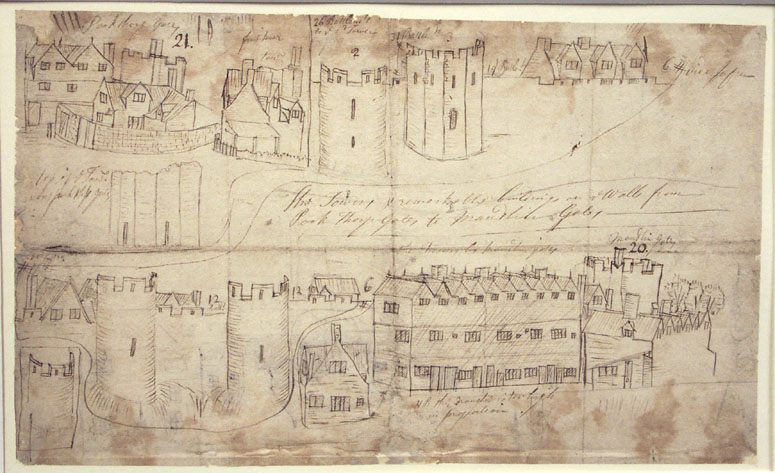
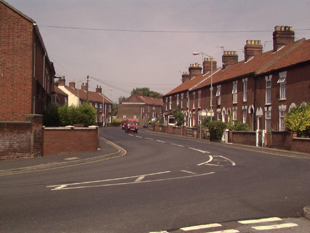
Blyth's Directory for Norwich of 1842 mentions that the wall from Magdalen Gate to Pockthorpe Gate (that is along Bull Close Road) 'is partly built upon, but a great portion of it has fallen down through neglect or decay'. [Blyth, page 5] Map evidence and historic illustrations:Historic maps of the City are not accurate enough to trace precisely the line of the wall nor even to determine exactly the number and positions of the intermediate towers. Cunningham's map of 1558 is in fact a view of the city from the west so this section of the wall is on the far side. It shows just three intermediate towers. However, it is important as evidence in that no buildings are shown against the wall on either side. The land inside the wall was mainly gardens. Cleer's map of 1696 shows just two intermediate towers on this section and is obviously simplified. Hochstetter's map of 1789, completed just before the gates were demolished, shows the wall standing for the whole length and appears to show five towers. At that stage, there was still no encroachment on Wall Lane, inside the defences, and only one building against the outside of the wall close to Magdalen Gate. By the time Morant's map was published in 1873, the central section of the wall between Pockthorpe Gate and Magdalen Gate had been demolished. Bull Close, linking Cow Gate Street and Bull Close Road, breached the defences and the section of the wall from there to the line of the later Leopard Court had gone. Only one tower of the five between Magdalen Gate and Bull Close Road tower is shown. This appears to be the eastern-most semicircular tower, about half way between the modern streets known now as Silver Road and Charlton Road. Wall Lane survived from Bargate Street (now Barrack Street) as far as the semicircular tower and from Bull Close to Magdalen Street. There were few buildings immediately against the wall on either side apart from three gable ends of narrow buildings running back to the north side of the wall from Bull Close Road, a building abutting the north side of the wall immediately west of Bull Close Road tower and three small square structures against the wall at the east end. There was little development outside the city wall on the north side of Bull Close Road where there were still open fields and orchards. John Kirkpatrick sketched some features of the wall in the 1720s but the drawings are slightly ambiguous. [3] On the single sheet are drawings of Pockthorpe Gate and Magdalen Gate though both are shown tightly surrounded by buildings. There are sketches of two polygonal towers, one with ruined battlements, and four semicircular or open intermediate towers. These have wide merlins with loops pierced through them and on three of the semicircular towers there are tall narrow loops at lower levels. The section of wall close to Magdalen Street has a distinctive building that appears to stand immediately in front of the wall. This is shown as having three stories, the upper floor having small mullioned windows and a continuous run of ten gables. More recent work along the line of the wall:In the late 19th century there was extensive new building work in the north part of the city, both inside and outside the wall. These buildings are recorded on the map that was surveyed by the Ordnance Survey in 1883 and published in 1887. At that stage almost twice as much of the wall to the west of the surviving tower was standing and the wall between the tower and the site of Pockthorpe Gate survived. The houses immediately west of the tower, on the south side of Bull Close Road, are dated 1887 and the long terraced rows to the north must have been built shortly after. General description:The land along the course of Bull Close Road rises from 3 metres above OD at the site of Pockthorpe Gate to 7.6 metres at the junction of Bull Close Road and Spencer Street. From there, for the last 125 metres to the site of Magdalen Gate, the line of the wall was almost level. [Map 04-01] The present ground level, particularly on the north side of the wall are much higher than the medieval levels, possibly by as much as 2 metres, and there is no surviving evidence for the ditch that ran along the outside of the wall. This must have been quite wide and deep, as it was, in part, an important conduit for water running down off Mousehold Heath and it probably took all the water draining into the ditch from as far round the circuit as St Martin's Gate. [see report 11] Modern plot boundaries and the present road alignment suggest that the ditch was at least 15 metres wide and it was probably 7 or 8 metres deep. As late as 1909 two short sections of wall survived. These were towards the middle of Bull Close Road. The 1910 survey records that
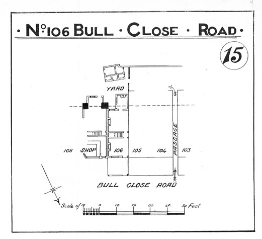
The houses marked as 105, 106 107 and 108 on the map published in 1910 were presumably demolished when Charlton Road was widened. [4] In the car park behind the public house west of Charlton Road and in Leopard Court the vertical bank marking the inner line of the lane inside the wall can be seen clearly. From the wall surviving on the west side of the Bull Close tower as far as Magdalen Street there is no section of the wall surviving or at least visible above ground. [5] However, the surviving wall there and the section of wall to the west of Magdalen Gate would indicate that the wall along Bull Close Road was at least 1.9 metres thick and approximately 4 metres high to the level of the wall walk. From evidence elsewhere, the parapet would have added between 2 metres and 2.4 metres to the overall height. The survival of arches supporting the wall walk at Bull Close Tower and arches west of Magdalen Gate would suggest that the whole of the wall between the Bull Close Tower and Magdalen Street Gate may have been arcaded. However, an 18th century view of Pockthorpe gate indicates that at that stage there was no arcade on the first section between the gate and the first tower. Archaeology reports, future conservation and potential excavations:Most of the evidence for this section consists of SMR reports and NAU watching briefs. SMR NF396 notes that 19th-century terraced houses were built along the line of this section of the city wall (nos. 112-134) after large sections of it were 'simply pushed over to the south'. The level was then made up to the higher level of Bull Close Road, a retaining wall of brick was built 'to revet the dumping', and the houses were then built on this platform. A machine-dug trench for the foundations of a new housing development exposed the inner face of this 'tumbled' wall in 1972. A sewer trench dug in 1972 at the east end of Bull Close Road overlay the line of the outer edge of the city ditch, but cut only through modern rubble and soil. [SMR NF354]. A watching brief for Anglian Water in 1989 for the area from Whitefriars Bridge to Bulll Close Road (along Charlton Road) revealed a re-deposited block of masonry from the city wall, and a deep feature, possibly a 10th-century defensive ditch, but no other relevant finds. The trench included a section 7.3 metres long over the line of the wall at the junction of Bull Close Road and Charlton Road. Here, about 2.34 metres below the modern ground level, part of the wall was observed running across the trench at an angle. [SMR NF 834] The secondary file (extant) shows the plans for this and discusses the site in more detail. In 1999 work started on the restoration of the houses immediately to the east of the site of Magdalen Gate. An engineers report was commissioned from the Morton Partnership which included digging a bore hole into the former ditch in the side yard of the house. One bore hole, presumably over the ditch, recorded loose fill to a depth of 6.7 metres indicating a possible minimum depth of the medieval ditch at this point. [see copy of report in appendix] The road north of the site of Magdalen Gate is just 7.6 metres above sea level, and that is certainly above the medieval ground level. The implication is that for much of its length the bottom of the ditch along Bull Close Road was relatively level and could have been flooded by water from the river rather just by rain water running off higher ground to the north. As part of the same redevelopment, a report on the buildings at the corner of Magdalen Street and Bull Close Road was commissioned from Robert Smith in 1999. A substantial wall built in flint had been uncovered as a cross wall within the building and this was initially considered to be an upstanding part of the wall. Robert Smith observed blocked windows in the wall and established firmly that it was in fact the gable end of a building immediately inside the wall and that the narrow lane ran between this wall and the defensive wall itself. With housing along the full length of Bull Close Road and the importance of the road itself, there is little prospect of further archaeological work apart from the need to stipulate a watching brief should work be undertaken on the houses or services along this section. Future excavations could determine the exact position and plan of the intermediate towers and could determine which sections of the wall between Pockthorpe Gate and Magdalen Gate had an inner arcade. BIBLIOGRAPHY:G K Blyth, The Norwich Guide and
Directory (London: R. Hastings; DOCUMENTARY REFERENCES:Gressen Hall File 834, containing NAU Watching Brief Report, Whitefriar's Drainage Trench (1989), and newspaper clipping from the Anglian News, May 1989, 'Flint Wells Found'. SMR NF 396 See also: HISTORIC
ILLUSTRATIONS IN THE DATA BASE: |