City walls survey
6 Magdalen Street Wall
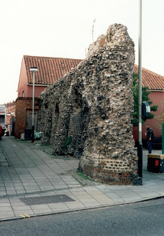 |
Conservation PlanThe present setting:The surviving wall stands at a very busy road junction with steady traffic using Magdalen Street which is now one way heading north and there is heavy traffic east west along Bull Close Road and Magpie Road. [see survey map 06-01] With traffic lights on the junction levels of pollution must be very high. Pedestrian traffic is also heavy. The east end of the wall is set back from the road by just 1.2 metres and people use both the footpath there and the archway through the wall. [Plan 06-02] On the north side of the wall is a roughly triangular area of trees and planting (see landscape report below) but tends to be used by drunks and dossers. Obviously these people are not a direct threat to the structure of the wall and many just sit on the seats relatively quietly. However any planting, landscaping or lighting scheme must recognise the problem. The walls are used very regularly as a toilet and local shopkeepers warned us to be careful as we surveyed because dumped needles were a serious problem. Dense ground cover near the walls might restrict access to some extent but could make the clearing of abandoned needles more difficult. On the south side of the wall is a narrow lane between the wall and the first shop on the west side of Magdalen Street. The lane provides general access to the rear of the terraced houses immediately beyond the wall on the south side of Magpie Road. This is the line of the lane inside the wall. The modern small paving here seems appropriate as archaeological evidence from Barn Road [see report 16] suggests that the lane was probably cobbled in the Middle Ages. At the west end of the wall on the inner side is a small EEB junction box that should perhaps be relocated. The disused public toilet should be demolished though the back north wall should be retained to keep the sense of enclosure. A gap here between the wall and the first building in Magpie Road would be inappropriate. The north side of the wall could be dramatically lit which would give the site much more emphasis as traffic approaches the city from the north. Landscape report by Christine Boswell:'A short section of surviving wall, recently restored, shows very little sign of weed cover. On the south side a granite set pavior base provides a good setting. On the north side a timber seat is backed by a corner landscaped bed which is well proportioned but quite barely planted. One very handsome Maple should remain. 2 No. Sambucas 'Elder' will quickly outgrow their corner space and should be removed. Ground cover is bare and comprises Cotoneaster varieties and Lonicera nitida. The soil was littered with empty bottles and debris. 3 No existing trees in tree gratings front the site perfectly. RecommendationsRemove Sambucas and Cotoneaster adjacent to the wall. The wall should be lit from the bottom right hand corner on the north side to spotlight one section of it. Replant with 2 No. Betula 'Fastigata' or utilis to provide a filigree effect. The ground cover should be dense and low growing so as not to obscure the wall. Mass plant with perennial ground cover. The following types are almost evergreen: Brunnera, Geranium maccrohizum and Pulmonaria 'Sissinghurst White'.' Potential medium or long-term improvements recommended for the surroundings:The wall would benefit from lighting preferably from below. There could also be an information panel with illustrations of the gate. Improvements to the landscape setting on the north side are discussed above. Archaeological impact assessment:There is little reason and with the heavy foot and vehicle traffic probably no opportunity to undertake organised archaeological work here. However the normal caveat applies that all trench work for services should be monitored. The specific features here that need further investigation are the ditch to determine its depth and width, the fore works of the gate and the site of the gate itself. The footings of the wall itself could reveal if the flint wall had been constructed on an earlier bank and it is possible that 13th and 14th-century levels and surfaces for the lane inside the wall may survive. Any work on the buildings and yards at the west end of the wall should be monitored in case evidence for the position and form of the first intermediate tower is uncovered. CONSERVATION REPORT SUMMARY WITH RECOMMENDATIONS FOR ACTIONSee annotated drawing 06-08
BIBLIOGRAPHY:Collins, Arthur E., The Walls of Norwich (City and County of
Norwich, DOCUMENTARY REFERENCES:No specific references HISTORIC ILLUSTRATIONS IN THE DATA BASE:View of the north front of the gate by John Ninham about 1790, published by |