City walls survey
6 Magdalen Street Wall
|
|
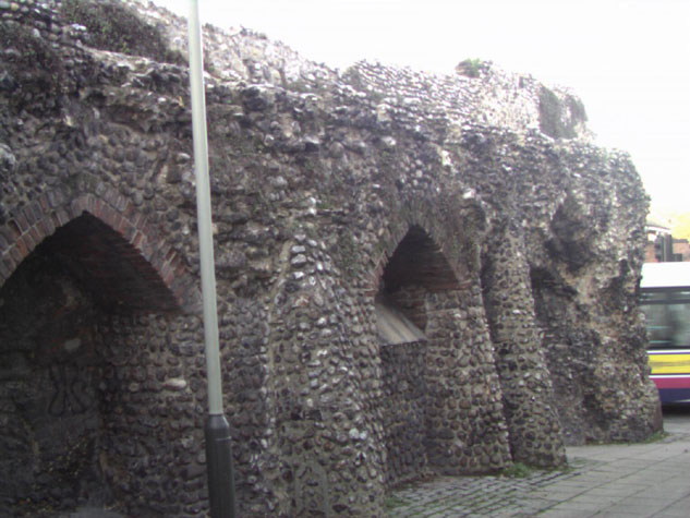
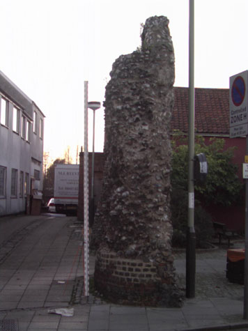
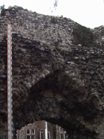
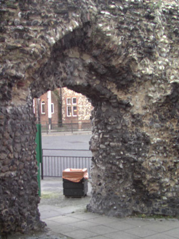
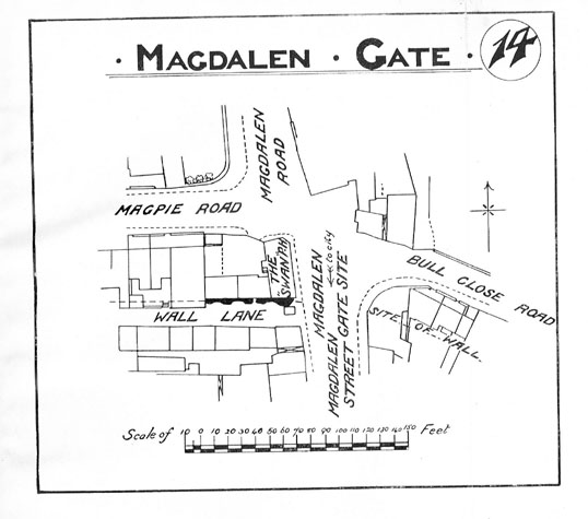
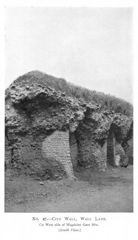
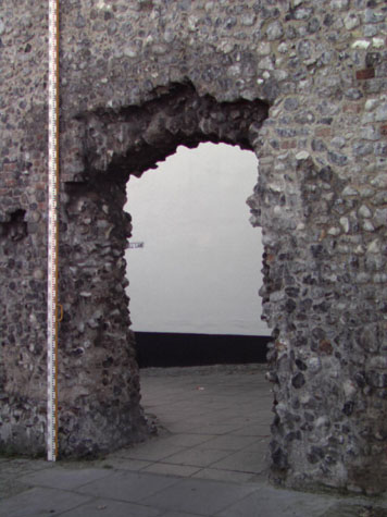
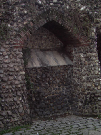
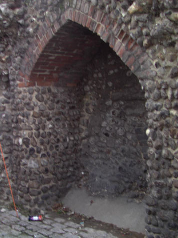
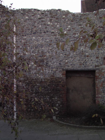
Historical Background ReportSummaryThis section of the wall is significant because it retains much of the inner arcade and because it abutted one of the main gates into the city. Although the arcade is in a poor state of repair, it shows clearly several important elements of the construction of the wall. [6] The arcade supported a wider wall walk and was constructed with shallow pointed arches with two or three rows of headers. [7 & 8] These arches were relatively widely spaced with two levels of brick-lined putlog holes in the centre of each pier. These indicate that the main part of the wall was raised in three stages or lifts. With bricks lining the putlog holes, scaffold timbers could be taken out and moved up for the next stage. The parapet would, presumably, have been built as a fourth lift. The area of flint wall surviving at the east end, closest to Magdalen Street, is wider than the intermediate piers. As elsewhere, the first arch after a gate or an intermediate tower was set further out than the width of the intermediate piers. The space above was where there was an inner parapet to the wall walk here and steps up to the upper chamber of the gate. At Magdalen Street the first arch appears to have been slightly taller and slightly wider than the following arches though there is no obvious reason for this. [9] The wall is set back 16 metres from the edge of Magpie Road which roughly defines the width of the outer ditch. The road is on the line of a lane outside the ditch but is presumably wider than the lane having encroached over the outer edge of the ditch. On the inner side of the wall the line and level of the medieval lane inside the wall survives. Documentary evidence: There are no surviving medieval or later documents that appear to relate specifically to this short length of wall. Map evidence:The early maps of Norwich provide little evidence that is relevant to this section of the wall although Kirkpatrick does show that by about 1720 there were long narrow buildings against the outer side of the wall on both sides of Magdalen Gate. These were presumably built over the line of the ditch which must, by then have been filled. Although, curiously, Hochstetter in 1789 shows this section of wall clear of buildings on the outer side, he shows the first intermediate tower of the wall between Magdalen Gate and St Augustine's as being very close to the west end of this section. Plot boundaries, that in part survive, suggest that it was probably between the west end of the main section and the small fragment of flint wall surviving in the back yard to the west. This would fit with the arrangement that survives at St Stephen's where the towers on either side of the gate were placed relatively close to the gate. This would have provided cover to the approach to the gate where the causeway or bridge before the gate made it vulnerable to an attack from the sides. It may be significant also that Hochstetter implies that the tower west of Magdalen Gate was circular. Many of the intermediate towers were semicircular and open to the back. However, the towers flanking St Stephen's Gate were enclosed or partly enclosed and vaulted. Presumably this provided a more substantial upper platform at the level of the wall walk or above for fighting troops, particularly for archers covering the outer approach to the gate. The first edition of the Ordnance Survey map of 1885 [sheet LXIII.11.8] shows the inner side of the wall, the line of the lane inside the wall, clear of buildings. However, there is a building against the north side of the surviving wall. This was around a courtyard open to the north and was identified as the White Swan Public House. Presumably, it was the demolition of this building that damaged the outer face of the wall. The map indicates that already the inner arches were irregular. The blocked doorway towards the centre of the wall appears to have been open and would have provided an entrance into the White Swan from the inner lane. The arch at the east end that is now open was drawn on the map as being closed. Historic views and historic photographs:The view of Magdalen Gate by John Ninham shows the upper part of this section of the wall. The embrasures of the battlement are shown widely spaced. [see above] A photograph of the wall about 1910 was published in a report on the walls by Arthur Collins. [Collins, 1910 plate 27] At that stage much more of the parapet survived but the arches were already in a parlous state though much of the east side of the upper part of the fourth arch survived. [10 & 11] This has now gone. Archaeological reports:Work by the City Engineer's in November 1957 uncovered part of the medieval wall behind number 134 Magpie Road (the house immediately west of the yard with the fragment of wall. Notes in the sites and monuments record [SMR NF261] record that the wall was about 7ft (2.13 metres) from the back of the house and 6ft 9' (2.05 metres) below the surface. It is not clear if it was the outer face of the wall that was 7ft behind the house or the part that was uncovered. Condition SurveyThe surviving section of wall is 17 metres long and stands to a maximum height of 5.3 metres from the modern ground level. It is at most 1.4 metres wide and has lost much of the inner face of the wall where three arches of the arcade supporting the wall walk survive. [Survey drawing of internal elevation 06-04] The piers of the arcade have been rebuilt with cobbles forming rounded piers. A photograph taken before 1910 [Report by Collins, plate 27] shows just how badly the lower parts of the wall had decayed and just how much of the upper flint work of the arches was unsupported at that stage. [11] Of the three arches the east arch closest to the road has lost most of its brick work. As the piers broke back the bricks of the arches would have been left unsupported and would have dropped out. [12] The middle arch has been rebuilt within the last 30 years but soft bricks were used with a hard cementitious mortar and water penetration from above has caused considerable damage. [13] The arch will have to be rebuilt within five years if the wall walk and remains of the parapet are not to be undermined and threatened with collapse. What remains of the third arch retains earlier brick but large areas of flint oversail the arch. [14] The oversailing flint should be inspected annually to ensure that it is still secure and safe and to monitor any problems with water getting in to the core of the wall. The wall walk and the broken line of the surviving part of the parapet were restored in 1999/2000 and are now in good condition. [Survey drawings of the east end and the cross section of the wall 06-05 & 06-06] Water seems to be running off the wall top well the most serious problem around the walls generally is with water ponding on the top or entering the core through setlement cracks or cracks caused by self seeded woody-stemmed plants. Once water and frost damage starts, the damage to the top of the wall progresses and accelerates as areas of flint are thrown out. Although the present state of the wall top here is good the state of the wall should be monitored annually and minor repairs or patching undertaken. Local people say that the walls are used as a climbing frame by kids and flints are regularly dislodged. If the toilet at the west end is demolished that will remove one easy route up onto the wall top. This problem also highlights the need to replace shed flints quickly to keep the face of the wall relatively level to reduce the number of hand and foot holds. On the north side of the wall there is much evidence of the damage caused by demolishing houses that had been built hard against the wall. [Survey drawing of the external elevation 06-03] There are areas of protruding brick where walls bonded in to the flint work have then been cut back, there is a doorway with wooden lintels, now blocked, and areas of render or rough mortar with widely spaced bricks and flints where lining out and plaster for internal wall faces has been cut away. [15] The wall is generally in a good state of repair following the recent restoration though there are some obvious problems with the mortar mix used. There is heavy leaching out of lime washed out by rain in some areas and the face is already crumbling away in some areas. The precise mix of lime and sand and aggregate should be assessed and the success of this repair monitored over several years to inform what may be done next on other sections of the wall. List of known repairs:The wall was under scaffolding in 1999 and 2000 when the flint work of the parapet was consolidated and the outer or north face of the wall was repaired and re-pointed. Unfortunately the face of the new work is already crumbling and breaking away and lime is leaching out of the mortar mix with rain. The proportions of the mortar mix that was used is not known but Brian Morton, when he inspected the wall, suggested that it needed a hydraulic lime mortar mix with a correctly graded course sand. [see brief note of visit in appendix] This area should be monitored and the success of the repair assessed to help determine the most appropriate method and mortar mix to use for repairs on other sections of the wall. Summary of present condition:Despite the extensive recent repairs, there are still problems with the state of the wall. The wall top is now presumably stable and throwing off water but the arches on the inner side and the flint work at the east end need urgent attention. Principal conservation problems:
|