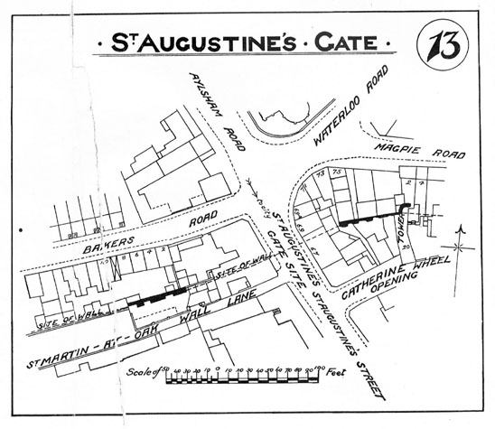
City walls survey
8 St Augustine's Wall
|
|
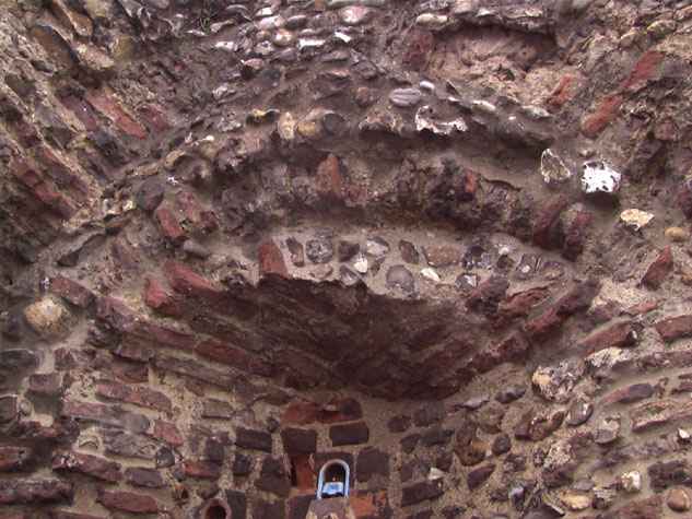
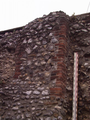
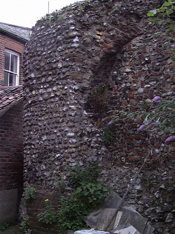
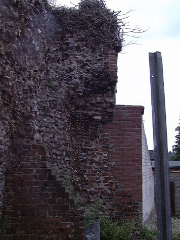
Historical Background ReportSummaryThe survival of the wall here with arches on the inner side, along with the survival of three arches at the east end by Magdalen Street, means, almost certainly, that the whole section of wall between the two gates had an inner arcade supporting the wall walk. The position of the tower on the angle of the wall where it could provide covering fire to protect both the gate and the wall further east, indicates how carefully the defences were planned to provide protection. [map 08-01] General description of the historic fabricThe standing wall is 18 metres long and about 5.1 metres high. The south face has been much damaged and cut back but the wall is still over 1.6 metres thick. [Survey drawings, plan 08-02 & elevation 08-03] The arches on the south side are badly decayed but it is still possible to reconstruct their original dimensions. The arches are now 3.2 metres high but the position of the loop now too high off the ground to be used and very obvious under building of the wall in brick shows that the medieval ground level has been taken down 770mm. The arches were originally about 2.5 metres wide and were 2.56 metres high to the apex and 1.5 metres high to the springing of the arch. The sill of the loop was originally 1.4 metres above the medieval ground level but is now 2.12 metres off the ground. The pier between the arches was about 1.8 metres wide. The lowering of the medieval level and the fact that the wall had to be under built, showing that there were no substantial medieval footings, would suggest that, as elsewhere, the flint wall was constructed on the top of an existing bank. This was levelled to provide a base for the wall that was constructed on shallow foundations on the front edge of the bank, the top of the bank itself providing a raised base for the lane inside the wall. The surviving loop in the eastern arch is different in form from those found elsewhere. The internal splay of the loop is much wider and the arched head of the opening is much shallower than the brickwork surviving for loops on the sections of wall at Coburg Street and Carrow Hill. [2] There is also much more brick around the loop, almost filling the area within the arch. It is not clear if these differences are because the wall itself may be of a later date than other sections or if the differences are because the loop was rebuilt or restored later in the medieval period. To the east of the east arch at an upper level is a pier of flint with brickwork on the angles like quoins. [3] Presumably this relates to buildings against the wall or to the structure of the house that was built within the tower and is shown on 18th-century drawings. A patch of brick appears to be the blocking of a third loop and at the east end, in an irregular projection of brick and flint, there is part of the springing of a fourth arch. The whole of the east half is set back from the inner wall line only the outer part of the wall survives here and this is obviously much rebuilt and refaced. The west end of the wall has been extensively rebuilt and refaced with pebbles and there is no evidence here for the next arch. [4] The printing works on the north side of the wall was built against and onto the top of the wall. This caused damage to the top of the wall and there is now no clear evidence for the precise height of the wall walk from the ground and none of the parapet survives. The tower, which is completely contained within the printing works, could not be surveyed at this stage. It was probably semicircular in plan though it is not known if it was closed across the back. Nor is it known if the ground floor was vaulted or if there was an upper level or if the tower simply rose to the same height as the flanking battlements. Documentary evidence:No medieval documents have been uncovered that relate specifically to this tower or this section of wall. However, it is known that the city walls were completed and existing gates and towers were strengthened about 1340 at the expense of Richard Spynk, a wealthy citizen of Norwich. The work he financed is set out in an account in 1343 that was transcribed and published by Tingey and Hudson. That account implies that Spynk was responsible for the construction of 45 rods of the wall between Magdalen Gate and St Augustine's Gate and four towers. [Extract from The Old Free Book, Hudson & Tingey, Vol. II, page 217] A rod could denote a unit of volume in building work, commonly for a wall 1 feet thick, but here it probably defines a unit of linear measurement equal to 16 feet. That means that the work undertaken about 1340, as well as the building of four towers, included about 226 metres of wall. Unfortunately, the rod was not a standard length throughout the medieval period and could vary from place to place. Even so this document is significant as the distance between the gates was 365 metres which would suggest that the rebuilding of the wall had been abandoned with this section of the wall only partly finished. The same document states that Spynk completed Magdalen Gate which had been left at the level of the vault and we know from other documents that the area further east around Pockthorpe Gate was one of the last sections of the wall to be completed. The wall around the city was almost certainly not rebuilt in a rational way starting at one point and working round year by year but this document does reinforce the idea that the north part of the city wall was the last part to be rebuilt and that work may have been completed working from west to east. Blyth's directory of Norwich in 1842 notes that the city wall 'from here to St. Magdalen gate is partly built upon from 'within-side' and the towers converted into cottages, as suggested by the sketches of Kirkpatrick, see below. Map evidence:Kirkpatrick's map of about 1714 shows the wall to the east of St Augustine's Gate and the tower as being semicircular in plan and open on the inner side. [Norwich Castle Museum 1894.76.1682:F] Eighteenth-century maps by Hoyle, Blomefield and King all show the wall and tower but provide little other evidence. All are, in part, views rather than strict plans and all show the wall from the south though none are at a sufficiently large or detailed scale to depict the arcade on the inner side of the wall. All show this section of the wall clear of buildings on either side. The map by Hochstetter dated 1789 shows buildings on the outer side of the wall, built over the ditch but open ground on the inside apart from buildings running back from the gate along the east side of St Augustine's Street. All these buildings appear on the drawings of the gates by John Ninham drawn shortly after the map was published. [Drawings published by Fitch in 1864] Historic views and historic photographs:John Kirkpatrick's pen and ink sketch, 'Tower from Magdalen Gates to St. Augustine's Gates and Houses by St. Augustine's Gates' [5] (undated, but probably drawn before 1720) shows towers and houses along this stretch of wall. [Norwich Castle Museum 1894.76.1689:INT] A second sheet of pen and ink drawings by Kirkpatrick includes a sketch of the top of a crenellated tower with a house built within it. [6] [Norwich Castle Museum 1894.76.1686:F] The house has a steep pitched roof with a tall dormer with double gables and two windows. The sketch is labelled 'house on ye top of Towr next St Austins gates' and must be the tower surviving within the printing works rather than the tower to the west of the gate. That is also shown and identified separately on the same drawing. The sketch of the top of St Augustine's gate on the same sheet of drawings shows the wall to the east of the gate abutting the gate at about the centre, just to the south of a chimney serving a fireplace in the chamber over the gate. Kirkpatrick also shows a doorway with an arched head leading from the chamber onto the wall walk. This may in fact be inaccurate and this is significant when trying to reconstruct the line of the wall from the surviving section up to the gate. If Kirkpatrick's sketch is accurate the wall would have changed direction between the surviving section and the gate. However, the late 18th-century views of the gate by John Ninham shows that the steps down onto the wall walk from the chamber were by then protected by a high, steeply sloping parapet and possibly a roof. Although the junction of the wall and gate is hidden by the houses around the gate, Ninham shows clearly that the steps ran up to the gate on the north side of the projecting stack. This would imply a more rational arrangement of the wall with it continuing in a straight line from the surviving section and abutting the gate at its outer north-east corner. A photograph of the wall published in the report of 1910 [Collins 1910, plate 26] appears to show part of the wall walk and outer parapet surviving. [7] Archaeological reports:In 1997 a watching brief to observe the digging of foundation trenches at the rear of property on the east side of St Augustine's Street near the line of the city wall identified traces of the city walls and ditch, as well as 19th-century building foundations. [SMR NF26451] At a depth of only 500mm below the surface of the garden, the north or outer face of the wall was uncovered. In the subsequent report it was also pointed out that the houses numbered 71 and 73 St Augustine's Street, with a curved frontage on the corner of St Augustine's and Magpie Road, have deep cellars where they are built over the ditch. [8] A secondary report discussing these findings apparently exists, but was not located either at the NAU or Gressen Hall at the time of writing.CONDITION SURVEYList of known repairs:Minor repairs do seem to have been carried out on the wall but no records of the work have been uncovered at this stage. For instance, the wall within the west arch was refaced and the wall below battered out before 1910. Summary of present condition:The condition of the north or outer side of the wall could not be assessed. The main part of the wall is covered by boarding in the large work shop of the printing works. The west end is within a private yard behind high walls with a locked gate and the owner could not be found to arrange access. [9] None of the neighbours had a contact name or address and the property did not have a letter box. On the south side the wall is in a relatively poor state. Several large areas at the east end have been re-pointed with a hard grey cement mortar. [10 & 11] This section of the wall is set back from the front face of the surviving arches and was presumably cut back when buildings against the inner side of the wall and buildings within the tower were demolished. It is not clear how much of this wall is medieval. A large area of brick patching at the centre of the east end is in the right position to be over a loop or at least within the centre of a lost arch. There is a large area of core work breaking forward above the east side of the east arch. The brickwork of the loop itself is set back and to some extent it is therefore protected from the worst of the weather and is in surprisingly good condition. The flint work over the arch has been rebuilt with pebbles or nodules rather than knapped flints. [12] The apex of the west arch has broken away and there is extensive damage of the flint work and the remaining bricks in the arch from water penetration. The back of the west arch has been refaced with a mixture of random bricks and flints obliterating any evidence for a loop. [13] The base of the wall within the arch is sloped presumably to provide additional support where the ground level has been cut back. This is shown on a photograph of the wall published in the report of 1910 so is a relatively early repair. The west end of the wall has been refaced with pebbles and appears to be relatively stable. Principal conservation problems:There are problems with several areas of flint dropping out and the general poor state of the wall would suggest that extensive repair work will be required soon. However, it is difficult to know how any repair work should be best undertaken. If bricks or flints are replaced a more uniform appearance would destroy the character of the wall and could remove archaeological evidence. However, if little or nothing is done then the wall will decay at an increasingly rapid rate. Careful methodical re pointing is recommended to ensure that flints are securely bedded and that water is not entering the core of the wall. |