City walls survey
11 Baker's Road
|
|
Documentary EvidenceThere appear to be no medieval documents specific to this section of wall apart from the Customs book of the mid 14th century and the Roll of 1386 which names the wardens who were responsible for this section of the defences. The Agistamentum of 1451 states that Colegate Ward was responsible for maintaining the defences from the tower at Oak Street described as 'the toure by the water'to 'Seynt Awstyn Gates' Documents surviving from the 16th and 17th centuries suggest that not only was the ditch at Baker's Road filled with water but that it drained eastwards towards Pockthorpe Gate rather than the much shorter distance west to the river by Oak Lane. At an Assembly in 1553 (6th Edward VI)
In November 1622 it was ordered that
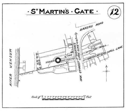
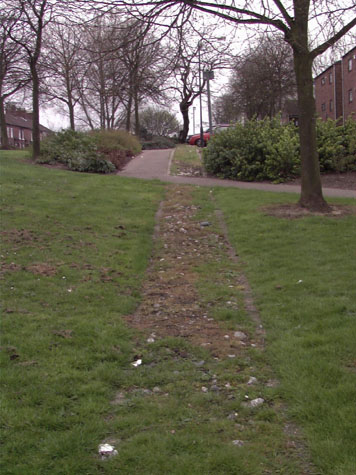
In 1861, Robert Fitch, in his introduction to the publication of the views of the gates, states that although there was then nothing remaining of St Augustine's Gate 'a large portion of the ditch between this gate and St Martin's is clearly seen, very few buildings having been erected upon its site.' [Fitch xxxv] Map evidenceCunningham's map or view of 1558 shows clearly two towers between St Martin's and St Augustine's. There was a leper house by St Augustine's Gate and this may have been built against or may have incorporated the east tower and both Cleer's map of 1696 and Corbridge's map of 1747 show a substantial, rectangular, two-storey building in the position of the eastern tower. [See Report 10] King's map of 1765 shows buildings along the south side of the lane inside the wall at each end close to the gates. By the time of Hochstetter's map of 1789 there appear to have been buildings against the inner side of the wall along most of its length. That map shows the west tower in this section as still standing and being circular in plan. Morant's map of 1873 shows buildings along the south side of Baker's Road and the first edition of the Ordnance Survey map of 1885 shows terraced houses along the south side of Baker's Road over the ditch. These houses were demolished in July 1973 and the site of the ditch is now clear. There is a photograph of the houses at the west end in the NNAS collection at Garsett House taken from the site of St Martin's Gate and they are shown on the sketch map of the site of St Martin's Gate published in the report of 1910. [2] General descriptionThis section of the defensive wall was at the northern-most part of the City. Baker's Road follows the line of the lane outside the ditch. [Survey drawing 11-01 Map] The houses on the north side of the road date from the late 19th or early 20th century. The south side of the road, on the line of the ditch, is open and grassed as a broad verge with some planting of trees. The line of the wall is marked by a narrow band of cobbles. There are no remains of either the wall or the intermediate tower visible above ground. Logic would suggest that the ditch along this section of the defences would have drained from east to west, the run-off entering the river above the Oak Street tower ... the present ground level at the site of St Augustine's Gate is approximately 10 metres above sea level and the natural slope appears to drop down towards St Martin's Gate where the present road level is less than 8 metres above sea level. The bank to the east of Oak Street slopes steeply, the level dropping a further 3 metres to the level of the grassy bank on the east side of the river. However 17th-century documents (see above) suggest that the ditch here along Bakers Road drained east towards Pockthorpe Gate. Presumably the ditch drained to the east in order to ensure that there was at least some water in the central section between St Augustine's and Magdalen Street Present state: archaeology. conservation and potential excavationsThere are no records of archaeological excavations in this area. As the site of the ditch is free of buildings and as this is a relatively quiet part of the circuit, without the traffic of Magpie Road and Bull Close Road to the east, some excavations might be possible in this area if funds should be available. [3] It should be possible to discover the full profile of the ditch and to investigate the footing of the wall. This would mirror and add to the information gathered from the section of wall along Barn Road following the excavations up to 1953. Once excavated, it would be possible to leave the ditch clear in this section. It should also be possible to determine the precise position and the form of the intermediate towers. If funds should be available then the line of the wall could be marked with a broader band of cobbles reflecting the actual width of the medieval wall. The cobbles reflect the present width of the surviving wall at the east end of St Martin's at Oak Wall Lane. However, the wall almost certainly had an arcade on the inner side for the full length between the gateways and would, therefore, have been at least 1.9 metres thick at the base. BIBLIOGRAPHY:Arthur E Collins, The Walls of Norwich (City and County of Norwich, DOCUMENTARY REFERENCES:Report from an Assembly in 1553 (6th Edward
VI) quoted in Fitch, on page |