City walls survey
17 St Benedict's Gate
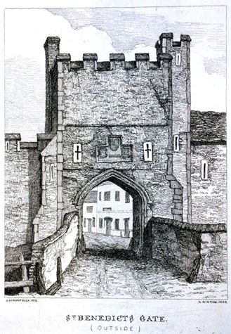 [2] View of the outside of St Benedict's Gate about 1720 engraved by Henry Ninham from the drawing by John Kirkpatrick [Norwich Castle Museum and Art Gallery 1954.138, Todd 5, Norwich, 111b]
|
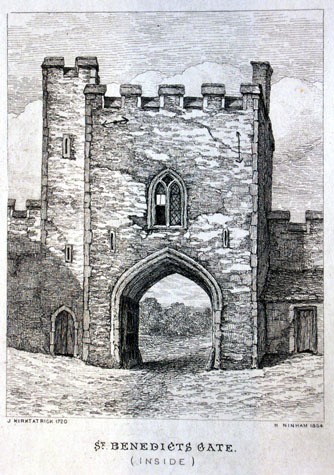
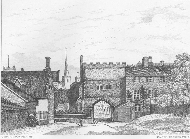
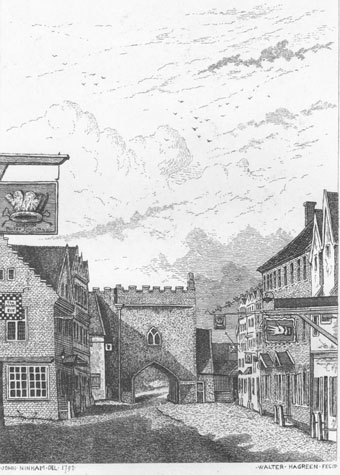
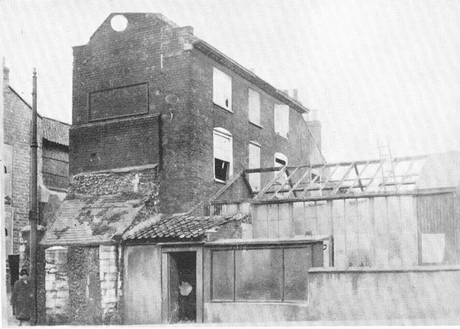
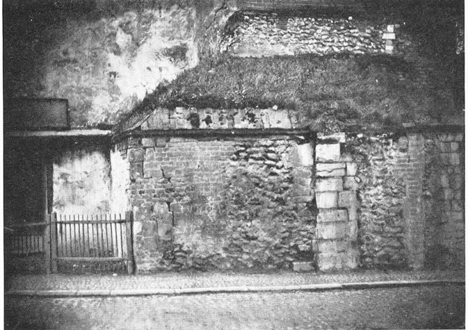
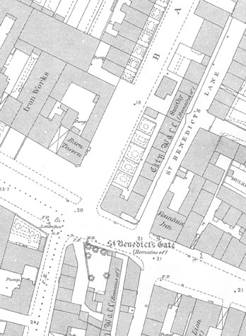
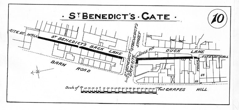
Historical Background ReportGeneral descriptionJohn Kirkpatrick's views of the gate in 1720 (engraved by Henry Ninham in 1864) [2 & 3]show clearly the inside and outside of the gate. [NCM Todd Collection, vol. II, box 5, 111a and 111b]He shows on the outside angled buttresses at the north-west and south-west corners and the archway of the gate is flanked by high parapet walls on either side of the bridge over the ditch. On the south side of the gate was a tall square turret that rose above the body of the gate and this must have contained a stair giving access to the chamber over the arch and to the roof above. He also shows an external stack on the north side presumably serving a fireplace in the chamber over the gate. Above the archway were three coats of arms, one above two, flanked by cross-shaped loops that appear to be cut in stone. Fitch states that these were the King's arms flanked by the arms of the City and the arms of St George. [Fitch 1861, page 19] Above the arms is shown an off set or string and at the top of the gate were five merlons. The stair turret was also crenellated. The wall to the north of the gate is shown as being tall and crenellated. The wall to the south of the gate appears to have a house built against it and the roof oversails the wall which is shown without battlements. The view of the inside of the gate contradicts this as it shows battlements on the wall to the south of the stair turret. The turret has a narrow arched doorway at the foot and there are two loops at intermediate levels presumably to light the vice. Over the archway of the gate was a two-light window with Y-shaped tracery of medieval form and on stylistic grounds, it dates from the 14th century. The main part of the gate looks as though it is in a poor state of repair, crumbling, with much of the top gone. There are braces visible on the left and right of the gate suggesting that it had suffered some collapse or settlement. The outside of the gate appears to be in better condition, although it looks as if some of the flint work to the middle is eroding, but this might be shadow. However, there is a large fissure to the top right. John Ninham's drawings of 1792 (published by Fitch in 1861) again show both the inside and outside of the gate. [NCM Fitch Collection 1768.76.94] These drawings show the gate as much wider than the gate drawn by Kirkpatrick but these views should be more accurate as Ninhan was said to have used a camera obscura to produce these drawings. The view of the outside of the gate [4]shows that by the end of the 18th century the coats of arms had been replaced by a pair of two light windows butted up to each other but under separate arched heads. The parapet with seven merlons appears to have been rebuilt in brick. By that stage the wall to the north of the gate had decayed and it looks as if much of the upper part had fallen. Ninham shows a three-storey house against the wall immediately to the south of the gate [5]and this survived though much altered until 1942 when it was damaged by heavy bombing in this part of the City. When the gate was demolished the south side (with one of the hinge pins of the gates) had to be retained because it was, in effect, the north gable of this house that had been built up and over the side of the gate. The high parapet wall on the south side of the bridge survived but by then was merely the boundary wall of the front garden of the house. The ditch had been filled in and the house and its garden were over the line of the ditch. [6] Collins in 1910 described the surviving side of the gate as being 11ft long and about 8ft high. He illustrates the hinge pin in plate 23 of his report. [7] This area was excavated by J Hurst and J Golson in 1951 and 1953. The results of their work and the finds recorded were published in the journal Norfolk Archaeology in 1957. The remains of the gate and the house to the south, described above, are illustrated by photographs as plate 10a, 10b 11 and plate 12. [6 & 8] They uncovered much of the south wall of the gate and recorded that it was 20ft long and 4ft thick, They also uncovered the base of the buttress at the south-west angle of the gate, The archaeological excavations also revealed the scale of the ditch at this point. It was at least 20 metres wide and over 8 metres deep. The ditch carried water draining from Grape Hill and to the north of the gate the water in the ditch was deep enough to be stocked with fish. The excavations did not extend to the bridge over the ditch as this was still buried beneath the modern road. However, the conclusions of the excavation report could suggest a sequence for the building of the walls and gate here. Excavation included trenches north of the gate on the line of the wall along Barn Road. It appeared that there had been an earlier bank here probably with a palisade. The gateway was constructed in flint possibly replacing a timber predecessor. The top of the earlier bank was then levelled and a shallow foundation dug and filled with layers of mortar and fine rubble before the present wall was built to abut the gate. Finds below the wall to the north of the gate suggest that that section was built shortly after 1300. Finds from the ditch suggest that it was kept relatively clear until about 1500 and then between 1500 and 1700 it gradually silted up. Deliberate infilling of the ditch began about 1700 and the ditch to the south of the gate was filled quickly. The ditch north of the gate was filled in by the middle of the 18th century. Documentary evidence The Treasurer's Accounts for 1385-6 record that two labourers working at Westwyk Gates were paid 7s,6d and that 5s was paid 'for a cart for 5 days at Westwyk Gates, while 15s 9 1/2d wre paid for making the ditch at Westwyke Gates. 8d were paid also 'For beer and the carriage of the gun', but this might not be related to work at the gates! [Hudson & Tingey, vol. II, pages 48-9] In 1451 and 1481 West Wymer ward were responsible for the repairs to the wall from the tower on the north side of St. Gile's Gate, along the walls and the towers to Westwick, or St. Bennet's gates. [Agistment for the Walls, Liber Albus, f. 177; Hudson & Tingey, vol. II, pages 313-5] In Kett's rebellion of 1549 the Earl of Warwick and his main army entered the City through St. Benedict's Gate. Unfortunately, carriages belonging to the army, loaded with ammunition, passed through these gates and continued across the city and straight out through Bishop Gates, delivering themselves, and their much needed ammunition, into the surprised hands of the enemy! [Blomefield, pages 248-9] In 1578 Elizabeth I visited Norwich on a great Progress. The gates were decorated for the Queen's pageant with 'cords made of herbs and flowers, with garlands, coronets, pictures, rich cloths, and a thousand devices.' [Blomefiled, page 349]The Queen's visit to the city and the role that the gates played in the pageant are recorded in detail by Zillah Dovey in her book on An Elizabethan Progress. [1996] Elizabeth rode out through the gate at St Benedict's on her way to hunt in the deer park owned by Lady Jerningham at Costessey. Robert Fitch retells one gruesome anecdote from Kirkpatrick about the gate. In 1615 Thomas Tunstall, a catholic priest was hung drawn and quartered. He said at his death that he was a Friar by vow but not by act, of the order of St Benedict. He died at the gallows by Magdalen Gate and his head was set upon a pole on St Benedict's Gate and his quarters on four other gates of the city. [Fitch 1861, page 19 quoting from Blomefield, page 366] In 1679 the Gate Tower was repaired, and on August 14th 1746 an order was made for the repair of the building over the arch of St Benedict's Gate 'being in great decay.' The work was to be undertaken as directed by one John Black. [Tonnage Books, N.R.O. NCR Case 19 Shelf C; SMR NF26166; quoted by Fitch page 18] Fitch also states that there were two inscriptions on the gate. One outside read:
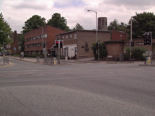
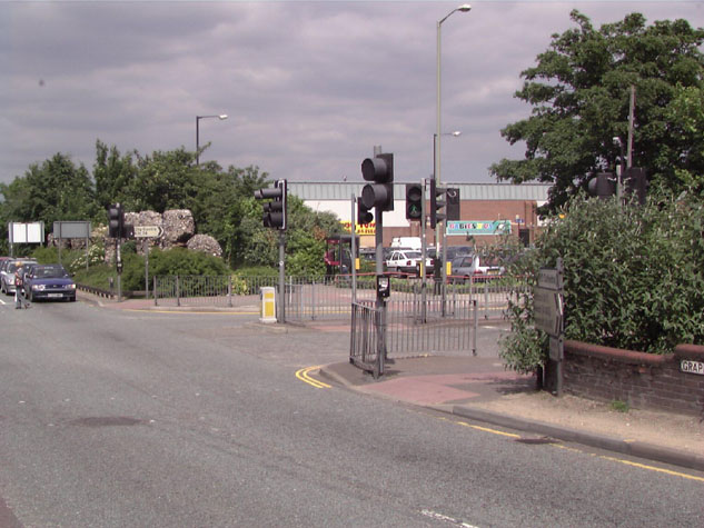
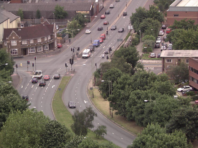
TEMPORE HENRICI WATTS On the tower inside the gate: REPARATA TEMPORE The gate was taken down in 1793, and a portion of the wall south of the gate remained when Fitch was writing in 1861. [Fitch, page 19] Map evidence: The gate is shown clearly on all the 17th and 18th century maps. Hochstetter's map of 1789, surveyed and published just before the gate was demolished, shows the gate in relation to the flanking walls. The wall to the north of the gate is shown as flush with the front face of the gate and the wall on the south side is shown as starting from the middle of the south side of the gate tower. Morant's map of 1873 shows virtually all the wall from St Gile's Gate to Heigham Gate as still standing. The first edition of the Ordnance Survey map of 1885 shows how quickly and how densely the land on either side of the gate was developed. [9] That map shows clearly the south wall of the gate and part of the main wall surviving, running south along Duck Lane. A sketch map of the site of the gateway was published in the report of 1910. [10] Present state: archaeology. conservation and potential excavations The site of the gate is at a very busy traffic intersection [17-01 Map]and there would seem to be little opportunity for any further archaeological excavations. [11, 12 & 13] Any road works at the junction should have an archaeological watching brief. There may still be evidence here for the bridge before the gate. If an interpretation panel is set up for the surviving section of wall to the south then information about the gate should be included with an illustration.
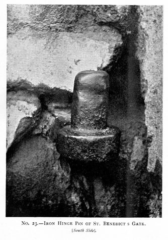
BIBLIOGRAPHY: See also:
DOCUMENTARY REFERENCES: HISTORIC ILLUSTRATIONS IN THE DATABASE: |