City walls survey
18 Duck Lane Wall
|
|
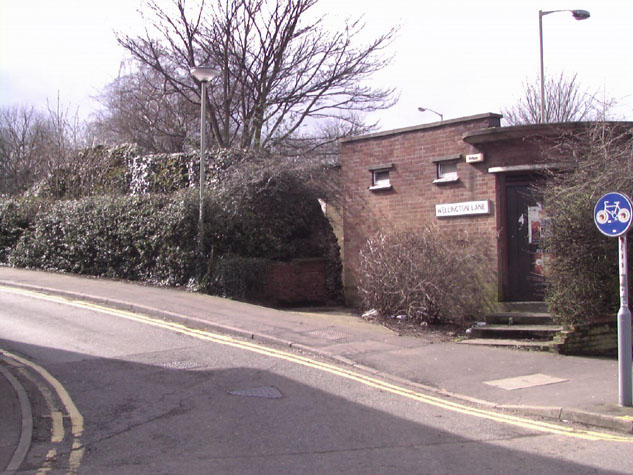
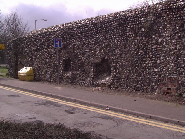
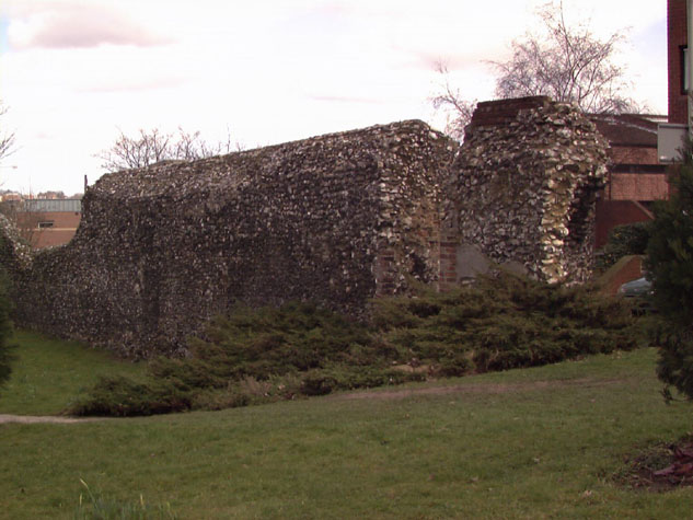
Conservation PlanThe present setting: The wall is set back from the dual carriageway on Grapes Hill with a broad verge of grass and trees to the front of the wall. [10] The north west corner of the wall is obscured by a redundant toilet block constructed probably in the 1960s. [11] The traffic driving west along St Benedict's is now restricted which improves the setting of this part of the wall. On the east side the narrow street is relatively quiet with modern houses on the city side and again traffic has been reduced by the restrictions on St Benedict's Street. The narrow pavement on the lane sits hard against the wall on the upper part. [12] Beyond the wall to the south, the line of the lost part of the wall is marked by a narrow band of cobbles. Landscape report by Christine Boswell: A large proportion of this section of wall is masked by the dilapidated toilet block on one side and by mature hedging on the other. Approaching the Grapes Hill traffic lights from the north the wall is completely hidden by a disused and dilapidated toilet block for approximately 30% of its length. The remainder of the western face is set into a grassed area with a group of three silver birch. At the south end of the wall a stepped opening is flanked by Juniperus horizontalis which in places is 1200mm high. On the eastern side of the wall 50% is covered by a clipped Pyracantha hedge. Other obstacles to the wall are a road sign and a yellow salt/grit bucket placed up against it. Recommendations:
Potential long-term improvements recommended for the surroundings:Enhancement of the display of this section of the wall must be planned in conjunction with work on the surviving wall on Barn Road just to the north of St Benedict's Street. [report 16] At the moment there is no visual connection between the two parts but in fact here the sections of standing wall extend over a distance of 115 metres. No advantage is taken of the open space around the outer side of the wall and the attractive topography with the slope of Grapes Hill and the wide areas of grass and trees. [13] The area to the north of St Benedict's should be improved by excavating the modern ground level and by taking the footpath that runs inside the wall further back. There would also be an opportunity to plant a new hedge of trees and mixed planting between the new path and the car park. That would provide a suitable backdrop to the wall and would provide a screen between the car park and the road. The aim here is actually to focus on the appearance of the wall from the outside. Removing the toilet block at the road junction in front of the Duck Lane wall and opening up the west side of the wall would make a visual connection between the two parts. Taking the ground level down on the site of the ditch would give a stronger impression of the appearance of the original wall. The wall south of the surviving section is marked by a narrow band of cobbles that in no way reflects the actual dimensions of the wall. The site of the lost tower should be excavated. If there are sufficient remains of the footings of the tower these should be left open for display. If the base of the tower has been robbed out then the outline of the tower should be set out in flints or cobbles and then the full width of the wall marked out as it continued up Grapes Hill. The present line of cobbles actually gives the impression of the wall being very feeble if people even understand what the cobbles represent. Archaeological impact assessment: If the outer ditch is in part reinstated there would be an opportunity to examine a much larger area than was investigated in the 1950s. Any smaller scale investigation of this area should focus on:
Conservation Report Summary with Recommendations for Action1. Immediate attention
2. Requires regular monitoring
3. Long term conservation
4. Improvements to the settingPriority
Long term
BIBLIOGRAPHY:Blyth, G.K., The Norwich Guide and Directory (London: R. Hastings;Norwich: Josiah Fletcher, 1842) Collins, Arthur E., The Walls of Norwich (City and County of Norwich, Norwich: Jarrold & Sons, 1910) Hudson, William, and Tingey, John C., The Records of the City of Norwich, vol. II (Norwich & London: Jarrold & Sons, 1910), pages 216-22, Extract from The Old Free Book DOCUMENTARY REFERENCES:ARCHAEOLOGICAL REPORTS:Hurst, G. & Golson, J., 'Excavations at St. Benedict's Gates Norwich 1951and 1953', Norfolk Archaeology 31 (1957): 5-112 Historical Illustrations:Harcourt, Bosworth, Old City Wall in Duck Lane St. Giles between St. Gilesand St. Benedict's Gate', Norwich Castle Museum 1922.135.BH15:INT |