City walls survey
18 Duck Lane Wall
|
|
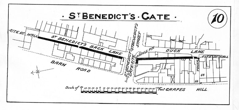
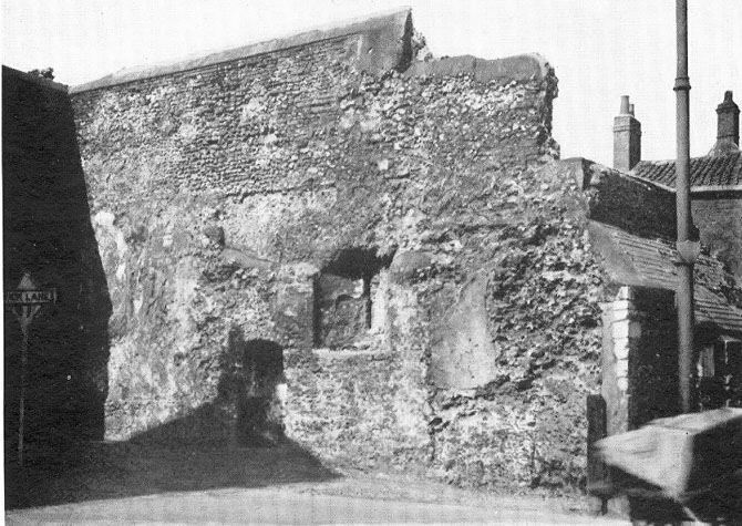
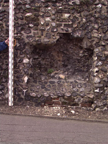
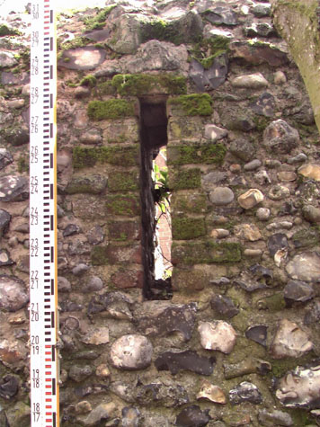
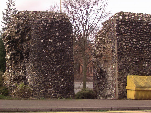
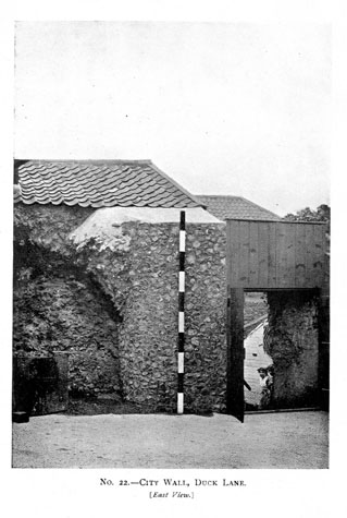
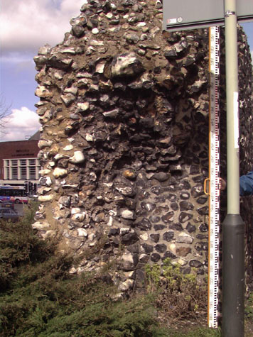
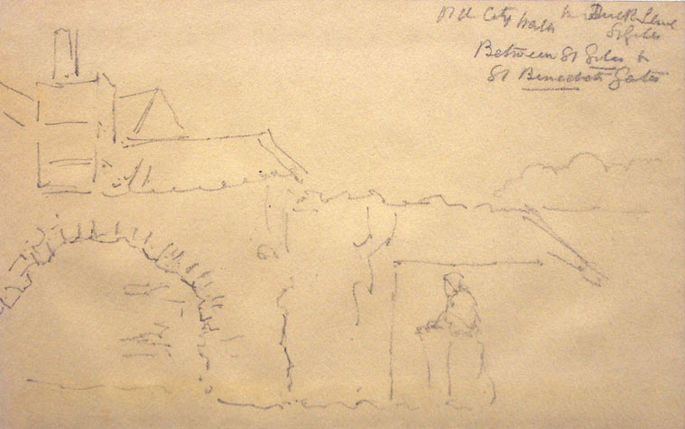
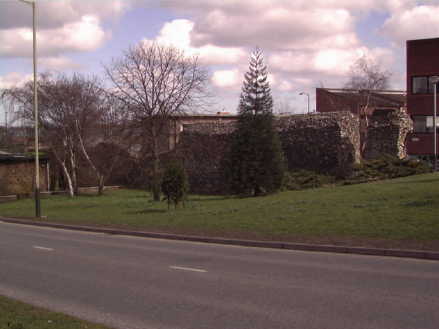
Historical Background ReportGeneral description of the historic fabricThis section of the wall was damaged by the construction of houses against it on both sides in the 19th century. [2 & 3] Much of the inner face of the wall was lost when the houses were demolished [4] and a deep plinth of flint behind bushes on the east side could indicate the line of the wall face. [18-04 Int Elev] Further damage was caused by the impact of bombs that exploded close to the site of the gate during the Blitz in 1942. Although the wall is now clear of buildings the construction of a dual carriageway down Grapes Hill in the 1970s meant that the slope of the hill was altered and the ground level on the outside of the wall was lowered. [18-03 Map] The medieval ground level can be seen as a change in the mortar on the wall and some areas are under built in brick. [18-03 Ext Elev] Few features survive in this section. There are two loops formed in brick towards the north end on the outer face that are 6.4 metres apart ... more widely spaced than the arches on the north side of St Benedict's gate. [5] This may reinforce the suggestion that there was no arcade here. There is possibly a third loop towards the centre of the wall. This was marked on Hurst's plan published in 1957 and there are a number of bricks here but at a higher level than the other two loops. At the south end of the wall is a narrow gateway [6] that was in the yard of number 68 Grapes Hill and was presumably cut through to provide a way through from the yard to the back lane. [2 & 18-02 Plan] Beyond the gateway is a free standing pier of flint which incorporates modern brick work. This was at the north corner of the lost tower. [7 & 8] When Hurst and Golson dug their trench across the line of the ditch, they examined the footing of the wall at the end of the trench on both sides. This trench was about 9 metres from the north jamb of the narrow gateway and was just over 2 metres wide. They thought that there was evidence in the wall there for an arch that had been filled in and evidence that the inner face of the wall had been refaced. On their site drawing of the excavations they therefore attempted to draw an arcade based on the dimensions of the arches on the north side of St Benedict's Gate. [see full copy of report in the Appendix] These did not fit rationally with the surviving loops. It is possible that, because of the slope up from the gate, there were no arches on the first section. There are certainly no remains of bricks in the wall that would in fact suggest that arches had been demolished or infilled. With the slope of the ground there was also an awkward problem of steps in the wall walk and the crenellated parapet. The view of the gate in the early 18th century by Kirkpatrick (redrawn by Henry Ninham in the 1860s) shows that the parapet on the south side of the gate started at a higher level than that on the north. It may have started at a high enough level to eliminate most of the steps required to take the walk up to the first intermediate tower. The gate was unique in having an external stair turret. The reason for the turret is uncertain but it may have been required because the level of the wall walk was so much higher than the level of the chamber over the gate. On most sections of the wall the walk was reached from the chamber over the gate with steps down to the wall walk. It was also suggested by Hurst and Golson in 1957 that a flint gate here predated the wall. If this section of the wall was built up to an existing gate and the top abutted at a high level, a new stair turret added against the side of the gate would have been a simple solution to the problem of access to the wall walk. When Hurst and Golson excavated the area immediately to the south of the gate they found no evidence for the stair turret. The area had been disturbed by the cutting through of a footpath to take pedestrians away from the line of the main arch of the gate presumably after 1910. Little is known about the intermediate tower at the south end of this section though the report by the Ministry of Works in 1953 (quoted in full below) suggests that parts of tower could be seen then and must have been removed after 1953. A 19th-century drawing of this section of the wall shows a broad arch on the line of the wall on the inner face of the tower [Norwich Castle Museum 1922.135.BH15:F] and this arch is also shown on the photograph of the wall published in the report of 1910. [Collins, 1910, plate 22] [7 & 8] The tower was probably semicircular (in 1711 Kirkpatrick described the tower as horse-shoe shaped) and it is possible that the arch supported a vault for a platform or a chamber at the level of the wall walk. The form of the vault would, presumably, have been similar to the vault on the tower south of St Stephen's Gate. [9] Documentary evidence:There appear to be no medieval documents surviving that relate specifically to the construction of this section of the wall or to the lost tower. The 14th-century Customs Book records that there were 100 battlements on the wall between St Benedict's Gate and St Giles' Gate. As the distance between the gates was 275 metres this would suggest that, as elsewhere on the walls, the merlons were relatively broad ... about 2 metres wide. Elsewhere, the embrasures on the battlement were set immediately above the loops in the wall itself and there is no reason to suppose that that arrangement was not followed here. Blyth notes that this section of wall 'is built upon.' [Blyth, page 4] Map evidence:Historic maps from the 17th and 18th centuries provide little extra information about this short section of the wall. Kirkpatrick's map of about 1714 does show that there were, at that stage, no buildings against the wall either on the inner side or on the outside face of the wall over the line of the outer ditch between St Benedict's Gate and the first tower to the south. By the late 18th century the ditch south of St Benedict's gate had been filled in. Hochstetter, on his map published in 1789, shows buildings against the inside of the wall all the way between the gate and the first tower which is shown as being circular. There were also houses along the outer or west edge of the outer ditch facing onto Grapes Hill By 1885, the year of the first edition of the Ordnance Survey map, [sheet LXIII.11.17] there were houses hard against the wall on both sides. A late 18th-century, three-storey house at the north end of this section, hard against St Benedict's Gate, is shown on drawings and early photographs and appears to be built astride the wall. The 1885 map shows the surviving wall running through the house but the rooms on either side must have been very narrow. Almost certainly much of the wall had been removed for none of the wall survived above ground when the site was excavated in 1951. The house almost certainly encased the stair turret on the south side of the gate. Although this is not shown on the map, it does show the south wall of the gate arch which was still standing. [see report 17] The site of the first tower south of St Benedict's Gate, immediately south of this section but with no fabric now standing above ground, is shown on the adjoining OS sheet. [LXIII.11.21] The outline of the tower, which was circular or semicircular in plan, is not shown although it is known that part of the structure survived until the early 20th century. The site is identified as a Smithy. Several other towers around the walls were used for the same purpose presumably because the structure was very solid and the confined internal space, being tall and round, may have been appropriate for housing a forge. A map was published with the report by A Collins of 1910. This shows all the buildings as surveyed on the Ordnance Survey map. [2] Historic views and historic photographs:In the Castle Museum collection there is an undated 19th-century pencil drawing by Bosworth Harcourt entitled, 'Old City Wall in Duck Lane St. Giles between St. Giles and St. Benedict's Gate.' [NCM 1922.135.BH15:INT] This shows buildings on the other side of the wall apparently adjoining it, while the main part of the wall (without battlements) has a large arched recess, edged in brick. [9] To the right of this, more wall is visible, apparently free of buildings on the front, and without battlements. This could certainly be the inner side of the first tower as the arch in the drawing does correspond with arch shown on the photograph published in the report of 1910. [Collins, 1910, plate 22] Archaeological reports:The results of the digs in 1951 and 1953 were published in 1957 by Hurst and Golson. [Norfolk Archaeology 31 (1957): pages 5-112] Because the information in this paper is so important and because the general conclusions are applicable to other sections of the city walls, this paper has been reproduced in full in the appendix. In Duck Lane a trial trench the full width of the ditch was excavated. This revealed that the ditch had been altered in the 15th or 16th century to improve the drainage of waste material and that it had remained open and was kept clear until the first half of the 18th century. It was then rapidly and systematically filled in. [18-05 North Sec & 18-06 Ditch Sec] The main conclusion from the excavation of the ditch and from the work north of St Benedict's Gate was that the flint wall was constructed on the top of an existing defensive bank. This presumably had a palisade on the top but the gate, whose position was established well before the flint wall was built, may have been constructed in flint before the walls were rebuilt. The line of the standing walls and the alignment of the walls with the gates can best be explained by the problem of building the wall up to a gate that was standing. CONDITION SURVEYList of known repairs:Not available at this stage. In October 1953 the walls were inspected by the Ministry of Works. Their short report on this section of the wall is quoted in full as it throws some light on what has happened here over the last 50 years.
Summary of present condition:Generally good. There are few areas of damaged flint though the wall top is irregular and may need some attention and there are areas of hard re-pointing on the west side that should be racked back and re-pointed with a softer lime based mortar. |