City walls survey
19 Grapes Hill
|
|
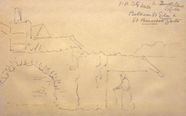
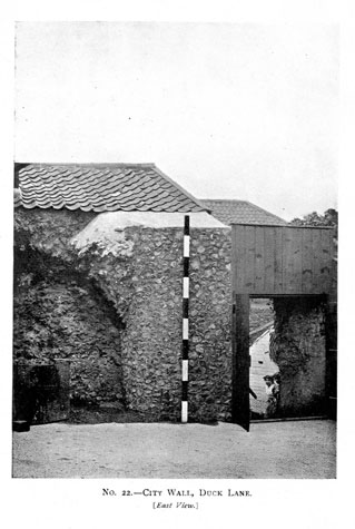
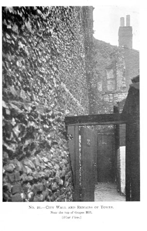
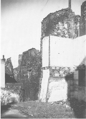
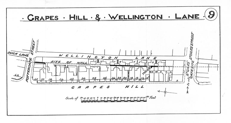
Documentary evidenceThere seem to be no documents surviving that provide any information about the construction of the wall and the towers though several references indicate how difficult it was to maintain the ditch. In 1281 the Dean of Norwich was fined 2s for enclosing part of the ditch near St Benedict's Gate (he was described as being amerced for he had made a purpressure) and he was fined 12d for carrying away clay and gravel. [Rot. Lete, 19th Edward I , quoted in Fitch page 17] In 1490 or 1491 (5th Henry VII) a 'cockey', possibly a form of drain, was constructed and the wall of St Benedict's Gate was altered. The work was extensive because it took 46 days to complete and needed eight loads of lime, bricks and 14 loads of stone from Mousehold Heath. This work was probably at the north end of this section and is discussed in more detail in report 18. The work was not completely successful or rather possibly too successful for in 1546 reference is made to 'a gret systern made at the Myddlyee Tower' north of St Benedict's Gate 'to receive all the fylth that cum from the cockey at Westwyck Gates.' [Comp. Cam. quoted by Fitch page 18] Other structures encroached on the ditch. In May 1344 Baudry de Taversham signed over his rights to a property in the ditch to the 'Baillives and Commonality of the city.' This was 'a piece of land in the ditch of the city of Norwich, near the Gate of S. Giles, in which place was sometime built a cottage for people diseased with the leprosy. Also I have released and quit claimed for ever ... all actions, challenges, and demands which I might have against them by reason of the destruction of the said cottage, or other action touching the said piece of ground.' The towers and walls also required upkeep. In 1628 the tower near St. Giles' Gate was inspected and a decision was to be made 'whether it be fit to take down the shed there or not, and whether to keep up the tower by anchoring or otherwise.' This should be the square tower. The tower to the south of the gate, later incorporated into the Drill Hall, was considerably further from the gate. In 1638 it was ordered that the walls next to St Giles' Gate should be stopped where they were broken. [Fitch, page 16] In 1842 Blyth wrote that this section of wall 'is built upon' [Blyth, page 4], and mentioned in particular 'Pottergate Tower', 'which is now converted into a habitable house' [Blythe, 1842]. He writes that there was formerly a postern at Pottergate, 'which has been stopped up for time out of mind', but that an opening has been made 'at the side of the tower'. This was presumably the middle tower. The first tower is mentioned in SMR NF261 in 1970 as a 'possible bastion seen at south end of existing wall', 53 yards from St. Benedict's street (TG22420880). Map evidenceThe map by Kirkpatrick of about 1714 [Norwich Castle Museum1894.76.1682:F] shows three towers in this section, both the south tower and the middle tower being shown as rectangular at that stage. Presumably the semicircular middle tower at the end of Pottergate had been rebuilt as a postern or narrow pedestrian gateway discussed above. John Hoyle in his map of 1728 [Norwich Castle Museum 1954.138, Todd 5, Norwich 11b] marks that postern with the same convention he uses for the gates showing a structure with two towers. This is a cartographic convention but at least it implies that there was a passage through the wall at that point. Curiously, Hochstetter in 1789 shows the middle tower as being again semicircular and also shows the first tower south of St Benedict's Gate as circular in plan rather than as an open horse shoe or semicircle described by Kirkpatrick. The square tower at the south end is shown but not coloured as being part of the wall. Hochstetter shows much of the ditch overlaid with gardens. In 1883, when this section was surveyed for the first edition of the Ordnance Survey map published in 1885, none of the towers are marked. The tower at the end of Pottergate had certainly been demolished since 1842 (see above) but it was shown on 'an old plan referred to by Order of Assembly, 23rd Octr., 1823 to be seen in the City Engineer's office.' [1910 Report page 39] Part of the first tower survived within a smithy [2] and the square tower certainly survived until 1939 although it is not clearly marked on the map. The surviving sections of wall and the positions of the towers are marked on survey plans published with the report of 1910. [Collins 1910, plans 9 and 10] General descriptionPart of the first tower after St Benedict's Gate survived in 1910. In the report of that year it was described as being at the rear of 64 Grapes Hill and the workshop at the rear of 66 Grapes Hill. A photograph of the wall from the east, from Duck Lane, shows a wide arch constructed in decayed brick. [1910 Report photograph 22] This was presumably the back arch of the vault of the tower and suggests that the form of the tower was similar to that of the tower surviving at the south end of Coburg Street. [Report 24] The narrow break in the wall survives at the south end of the Duck Lane section [Report 18] but everything to the left of the survey pole in the photograph has been demolished. [3] The report states that the tower itself was demolished in 1876. An ornate late-medieval wooden panelled door was found in the tower [1910 report illustration, page 45] but has nothing to do with the defensive wall. The 1910 report includes a photograph of the square tower that appears to have a substantial section of the wall surviving with it. [4] The caption states that the photograph was taken from the west though more logically this should be the view from the north. [1910 Report, photograph 21] The tower was behind 12A and 14 Grapes Hill and described as being 20ft (6.1 metres) high. A photograph of the tower from the south west, [5] taken shortly before it was demolished in 1939, was published by George Plunkett in 1990. [Page 47] In 1910 Collins described the wall then standing immediately to the north of St Giles'. 'About 80ft North of St Giles' Gate site is a section of City wall about 145 ft long, extending Northward. In it a portion of the tower North of St Giles' Gate. This walling is about 20ft high, and is situated behind Nos. 10, 12, 12a, 14, 16, 18, 20, 22, 24, 26 Grapes Hill, and can be approached by a passage between Nos. 18 and 20. The thickness at the base is not obtainable, but it is no doubt 3 ft. 3 in. like similar walling at other points. A portion of a battlement is still existing on the top of the wall, and the only other similar case can be seen to the East of Ber Street Gate site. The wall is in a fair state of preservation.'[Collins 1910, page 70] None of this wall survives. [6] Present state: archaeology. conservation and potential excavationsThe north end of the ditch here was excavated in 1951 and 1953 by J Hurst and J Golson. They established that the ditch was at least 22 metres wide and 8 metres deep presumably taking all the water draining off the higher land to the west and south. They recorded the position of loops in the wall and concluded that although there was almost certainly an arcade on the inner side of the wall, supporting the wall walk, this was for some reason irregular in spacing and could not be reconstructed.[Norfolk Archaeology, Volume XXXI 1957 pages 4 to 112] This major excavation revealed much about the form of the ditch and the construction of the wall suggesting that it post dated the construction of the gates and was built on the line of an earlier bank. The construction of the dual carriageway must have destroyed much of the archaeological evidence at the south end of this section. [7 & 8] However, an excavation of the central section near Pottergate which is clear of the road and buildings could reveal much about the complex history and development of the central tower or postern. In October 1953 the walls were inspected by the Ministry of Works. At that time part of the wall on Grapes Hill was still standing, presumably the section immediately north of St Giles' that was buried within the yards of the houses on the hill. The report is worth quoting in full:
BIBLIOGRAPHY:Blyth, G.K., The Norwich Guide and Directory (London: R. Hastings; ARCHAEOLOGICAL REPORTS:Hurst J G and Golson J, Excavations at St Benedict,s Gates Norwich 1951 and 1953,
Norfolk Archaeology, Volume XXXI, 1957, pages 4 to 112 |