City walls survey
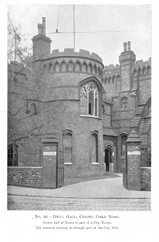
21 Drill Hall Tower and Wall
|
|
IntroductionFrom St Giles Gate to the gateway at St Stephens was about 655 metres and this was the single longest stretch of the wall on the circuit of the defences. There were 6 intermediate towers between the gates and the 14th-century Custom Roll indicates that there were 229 battlements on this section. This report covers the north section of the wall that ran from St Giles' Gate to the start of the surviving section of wall at the tower in Chapelfield Gardens. It includes the sites of the first and second of the six intermediate towers. Neither of the towers and none of the wall survives although there are photographs and drawings of the second tower that was incorporated into the Drill Hall built by J S Benest in 1866. [1] The Drill Hall was demolished in the 1970s for the construction of a large roundabout on the inner ring road but the position of the tower is marked in modern cobbles set into the grass on the roundabout. There is now no trace of the second tower which was 85 metres to the south. For the south part of the wall see reports 22, 23 and 24. Documentary evidence suggests that this may be the earliest part of the city wall for references are made to a wall here about 1256 (16th Edward I). Parts of the Saxon and Norman settlement of Norwich were protected by a ditch and bank and many of the principle streets were laid out then so the site if not the structure of many of the gates may have dated from the 12th century. Although the citizens of Norwich were granted a licence by Henry III to enclose the city in 1253, it is generally believed that the flint built wall was not begun until the raising of the first murage tax in 1294. [Fitch page v and page viii] |