City walls survey
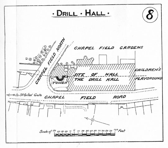
21 Drill Hall Tower and Walls
|
|
Documentary evidenceIn a Leet Roll from the 16th year of the reign of Edward I (1255/1256) the millers of the Prior of Buckenham had undermined the ditch between St Giles Gate and St Stephen's Gate and 'made a purpressure under the walls.' Purpressure generally refers to illegal enclosure or fencing in of land. The Prior's mill was in 'Chapply Field.'[Fitch page 12] Furthermore, in 1266 or 1267 John the Carpenter sold all 'his said messuage lying near the Gate of Needham', (St Stephen's Gate) to the Citizens and Commonality of Norwich, 'for their more convenient building of the wall of the city there.' [Dom.Civ. quoted by Fitch page 12] There appear to be no records surviving for the construction of the two lost towers. However, Kelly's Directory of Cambridgeshire, Norfolk and Suffolk for 1900 mentions that:
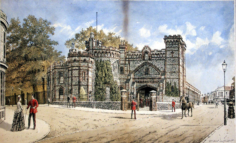
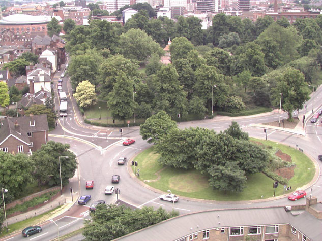
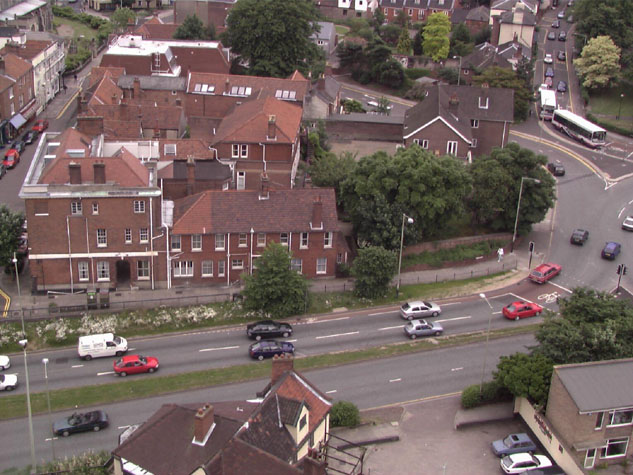
In the Report by Collins in 1910 there is a photograph of the Drill Hall with the remains of the tower on the left. The tower is described as being 13 ft (nearly 4 metres) high and incorporated into the lower part of the Hall. 'A piece of the City wall attached to the East side of the tower is now also part of the Drill Hall building which was repaired prior to a visit of King Edward VII., which took place on October 25th, 1909.' [1910 Report page 39] There is also a plan published with that report which implies that the medieval fabric was for a semicircular tower that was open on the inner side. [3] The Drill Hall is mentioned again in Jarrold's directory of 1914.[page 16] Map evidenceThis section of wall is shown clearly on Cunningham's view of 1558. He shows the open ground of Chapelfield with cattle grazing and human figures that appear to be archers practising. The wall is shown with a line of loops with a crenellated parapet. However there are only 5 towers shown ... the first two towers are shown but the south tower close to St Stephen's Gate has been omitted. Kirkpatrick too, shows only five towers but omits the tower that was at the end of Chapel Field East. He shows all the towers as being open semicircles apart from the 5th tower which is shown as being enclosed. [Norwich Castle Museum 1894.76.1682:F] This is the surviving polygonal tower on Coburg Street.[see report 23] Kirkpatrick studied the walls in some detail producing sketches and drawings of the towers and walls then surviving so his map should be reliable. He died in 1726 but the map may have been produced about 1714. The late 17th-century and 18th-century maps by Cleer, Hoyle and Blomefield do not depict the towers accurately but the version of King's map engraved by Hogenberg in the 1760s shows all six towers although the towers in Chapel Field are not shown in precisely the right positions. [Norwich Castle Museum 1954.138, Todd 7 Mancroft 37b] When Hochstetter produced his map of 1789, the whole of the wall between St Giles and St Stephen's was still standing. He shows the first tower just south of the north-west corner of the gardens as circular. This was the tower that was incorporated into the Drill Hall in the following century. That is difficult to reconcile with both Kirkpatrick's map and the plan published in the 1910 report and, if correct, would imply that the tower was restored or rebuilt sometime in the 18th century. The second or lost tower is shown as rectangular and open to the inner side. Again this is difficult to reconcile with other evidence. The ditch appears to survive with a fence or hedge along its outer edge. There were open fields beyond the lane on the outer side of the ditch. The first edition of the Ordnance Survey map at a scale of 1 to 500 was published in 1884 and 1885 though it was surveyed in 1883. The north part of this section, from St Giles' Gate to the Drill Hall, is shown on sheet LXIII.II.22 and at that stage only a short section of the wall survived behind two of the houses that faced onto Chapel Field Road. The wall is marked as being very narrow so presumably there was no arcade on that section at that stage. The site of the wall between the Drill Hall and the tower that survives in the gardens was published on sheet LXIII.15.2. That map shows that by then all the wall south of the Drill Hall and the second tower had been demolished and there was no trace of the defences surviving above ground. By then, the ditch had been filled in and there were houses all along the west side of Chapelfield Road. General descriptionThere is insufficient evidence surviving to describe this section of the wall or the two lost towers in any detail. [20-01 Map & 20-01 Map Det] More recent work along the line of the wallWork on the inner ring road in the 1970s must have destroyed any archaeological evidence for the first part of the wall and for the first tower in the Drill Hall. [4] No published archaeological reports have been found for any recording when the Drill Hall was demolished. There is a photograph in the NNAS collection at Garsett House of the medieval tower taken after the Drill Hall was demolished. This shows a wide opening on the north-west side lined with brick, described in the caption as a gun port lined with modern brick. Present state: archaeology. conservation and potential excavationsWhere the site of the wall has been excavated in other parts of the city it is clear that generally the wall had shallow foundations and little remains if the ground level is lowered. [5] However, in some areas the wall, when it was demolished, was tipped forward into the ditch and survives as part of the infill. Even evidence for the existence of an arcade might survive in the fallen walls as parts of brick arches. The intermediate towers, as they projected out over the ditch, had deeper and more substantial foundations on the outer side. There may be evidence surviving at the south end of this section, on the west side of the park for the wall and the second tower. [6] The ground level has been banked up here and planted with trees and shrubs. The mound or bank was described by Collins in the 1910 report. 'The mound ... to be seen here sloping away from the wall on the city side, and the thicker walling at the base. Probably, of still more ancient construction is also visible here.' [Collins page 39] There are several priorities for archaeological investigation:
BIBLIOGRAPHY:Austin, William Fred, 'Drill Hall St. Giles Corner of Chapel Fields', NCM Directory of the City of Norwich, including its Hamlets (London: Jarrold & Sons, 1914) Drill Hall Chapelfield (photo), NCM Todd Collection Vol. II, Box 7, Mancroft, p. 167 HISTORIC ILLUSTRATIONS IN THE DATABASE:In the Norwich Castle Museum and Art Gallery: |