City walls survey
26 St Stephen's Tower and Wall
|
|
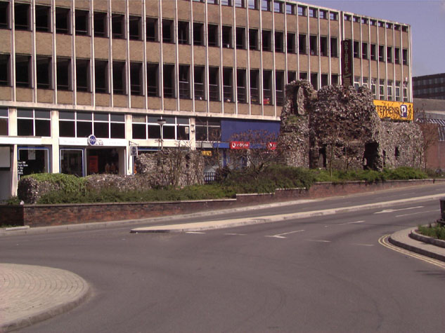
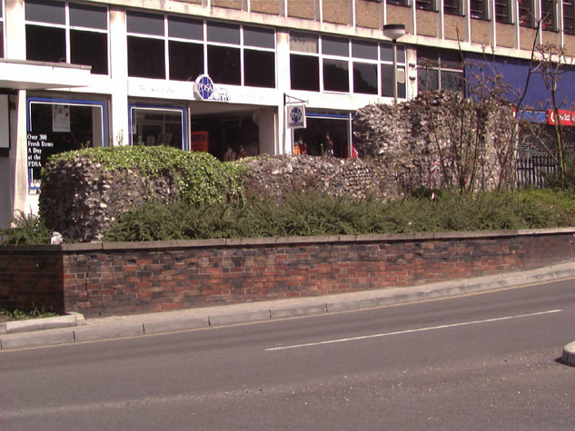
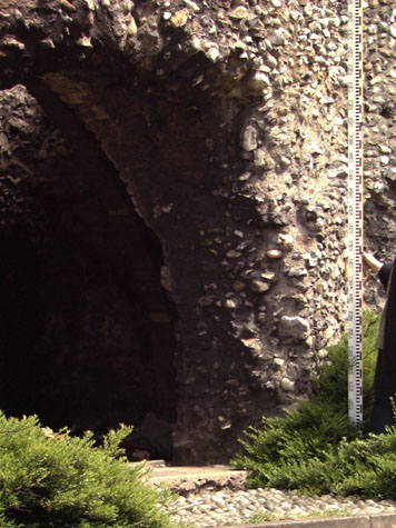
Conservation PlanThe present setting:The tower is close to one of the main entrance roads into the city. It is hard pressed by a busy dual carriageway on the west side on the line of the ditch and this road was cut down as it approaches the roundabout to the north at the junction of Queen's Road, St Stephen's and Chapel Field Road. This means that the tower and wall now stand above modern retaining walls in brick with concrete copings. [21 & 22] The area in front of the tower and walls is densely planted with shrubs and small trees that obscure much of the wall, particularly the lower section to the north. On the inner side of the tower is a wide pavement with mixed surfaces between the tower and a 1960s or 1970s block with shops below and multi-storey concrete car park above. The building does not provide an appropriate back drop to the tower. Heavy pedestrian traffic along the path does actually prevent the sort of vandalism seen in other areas. For instance the arches of the wall north of St Stephen's are used as toilets and are used as a dump for beer cans and other rubbish. Telephone boxes, a parking area for mopeds and bikes and the general poor state of the landscaping around the tower make the area look tired and neglected. The tower is regularly filled with evidence of occupation by people sleeping rough. There are often blankets, boxes and food cans and empty bottles in the tower. Generally the use of cobbles to mark the line of the wall in other areas is not that successful because the bands set in the ground are too narrow to give a real impression of the actual scale of the wall. Here however, the tower is visually isolated and a broad band of flints or cobbles the real width of the wall set in to the ground to the north and to the south running on towards Surrey Street would reinstate the line of the wall and would suggest that the tower was part of a much larger and very significant structure. Landscape report by Christine Boswell:This prominent section of City wall is planted on the south side with small trees and ground cover shrubs which are now 900-1200mm in height and starting to obscure the wall. The western end is completely covered in ivy and the tower is becoming an empty space for rubbish to blow into. On the north side of the wall the area is broken down into three main spaces: a paved area to the north of the tower where scooters and mopeds are parked, to the north of the linked railings section of deep Cotoneaster ground cover with an indent for a seat (dilapidated timber and a cobbled section adjacent to the steps to the underpass. The eastern end is planted with trees with a spreading canopy which are rubbing against the wall and causing damage. The trees are also suckering and they should be removed. The wall is uplit from the south side and the medieval ground level is lost. Recommendations:
Potential medium or long-term improvements recommended for the surroundings:This is an important part of the medieval wall and is in a prominent and well used area of the city. Redevelopment of the bus station site and potential work on upgrading the shopping street of St Stephen's could provide an opportunity for an extensive and more adventurous restoration of the tower and its setting. There is nowhere around the walls where there are prominent information boards or any form of easily accessible displays about the 13th-century defences. If the tower was restored it would be a very appropriate site for a small display. If the door on to the pavement, now closed by a fixed grill, was reopened and the break in the outer side was closed in and the loop re-instated, the tower could be made secure. [23] There is power in the tower and robust display panels could be lit. The door into the tower would have to be shut and locked at night and re-opened in the morning but otherwise would not have to be manned. Some form of grill or possibly a free-standing glass roof immediately above the vault could be considered as a way of stopping youths climbing into the tower or climbing out from the tower on to the top of the vault. Besides giving basic information about the tower and the wall here, a primary function of the display would be to direct people to walk on to other sections to explore other parts of the medieval wall. Archaeological impact assessment:Archaeological investigation of sections of the wall to the south of the tower should be considered as part of the development of the bus station site between the tower and the site of the next gate at Brazen Doors at Surrey Street to the south. Any construction work around the present entrance into the bus station from Queen's Road could cut across the site of the lost intermediate tower. Any trench across the line of the wall must be monitored to record evidence of the profile of the bank, record sections of wall uncovered, record the form and depth of any footings to the wall and the profile of the inner edge of the ditch. The level and surface of the lane inside the wall should also be recorded if and where it is revealed. Conservation Report Summary with Recommendations for ActionImmediate attention
Requires regular monitoring
Long term conservation
Improvements to the settingPriority
Long term
BIBLIOGRAPHY:Blomefield, Francis, An Essay Towards the Topographical History of the DOCUMENTARY REFERENCES:N.R.O. MF/RO 29/3 f. 177 (Liber Albus) HISTORIC ILLUSTRATIONS:Plunkett, George Rambles in Old Norwich , 1990 photographs on page 24 |