City walls survey
26 St Stephen's Tower and Wall
|
|
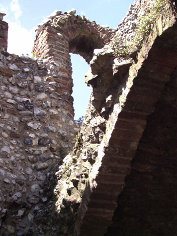
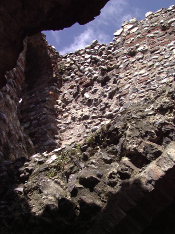
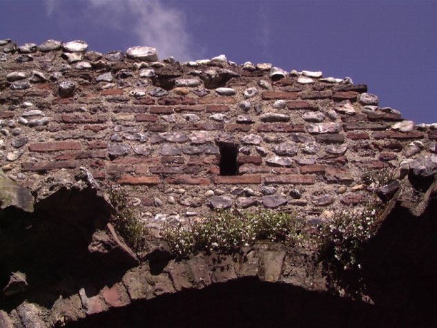
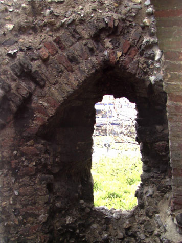
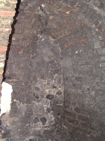
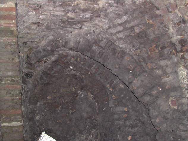
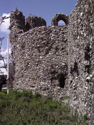
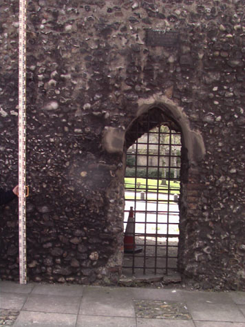
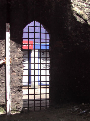
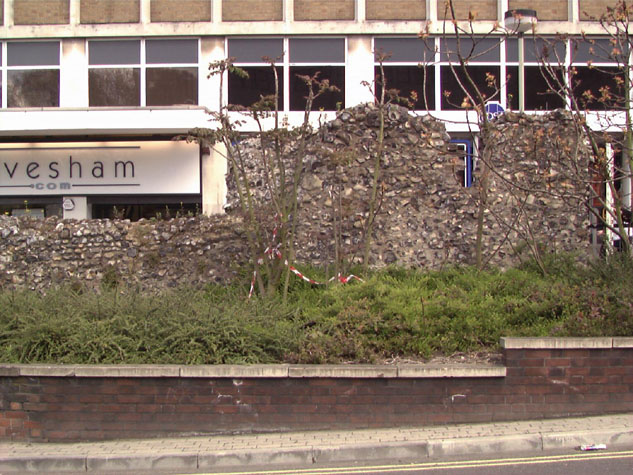
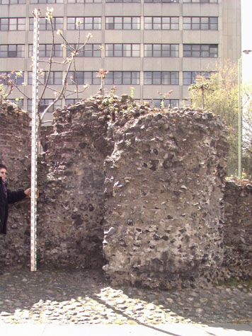
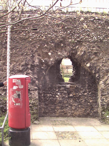
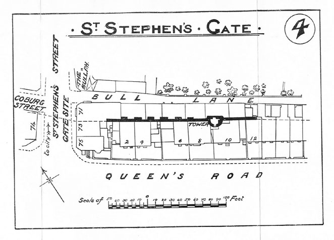
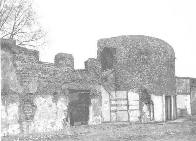
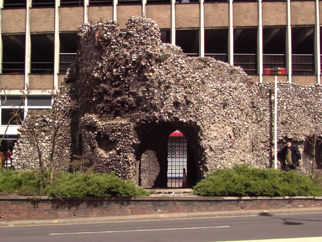
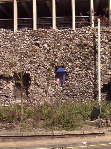
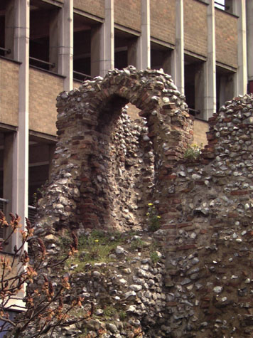
Historical Background ReportGeneral description of the historic fabricBetween St Stephen's Gate and Brazen Doors was a distance of about 220 metres. [26-01 Map] The wall was on almost level ground and ran in a straight line with the outer face towards the ditch facing almost south west. The only standing section is about 22 metres on from St Stephens and here the tower and the wall together survive for a distance of only 38 metres. The tower is 6.7 metres across and the outer wall projects into the ditch by 2.7 metres. [26-02 Plan] This is approximately the same size as other surviving towers though the outer curve of the tower is sharper or more pronounced than that of the three towers to the north of St Stephen's Gate suggesting possibly a later or at least a different building date. The surviving wall of the tower is just over 6 metres high from the modern ground level. The upper wall survives to the top of the loops but there is sufficient evidence to suggest that here at this tower there was an upper chamber and not just a platform at the level of the wall walk. The floor of the chamber was several steps up from the level of the wall walk. The lower chamber was vaulted with the vault supported on a single brick arch parallel with the flat back wall of the tower and just inset from it. [2] A similar arch survived until the early 20th century on the tower south of St Benedict's Gate. [now lost, see report 18] The arch is a curious form of vaulting and allows for the possibility that the lower chamber was actually open on the inner side with the arch supporting the inner wall of the upper chamber. There is, however, no evidence for a secondary phase in the construction of the vault though much of it is broken away by collapse and decay. [3] There no evidence for an internal staircase breaking through the vault so the upper chamber could only be reached from the wall walk. Nor is there evidence in the surviving walls of the upper chamber for an internal stone or brick staircase up to the top level. As the upper parts of the wall have gone it is now no longer possible to see if the tower was simply roofed or if there was a roof gutter with a walkway behind a high parapet or even if there was a platform at the roof level. Any walk at roof level could have been reached by way of a ladder and hatch from the upper chamber. The straight inner wall of the first-floor chamber is extensively patched with brick but there is no evidence to suggest that there was ever a fireplace in the upper chamber.[26-11 Tow Eas Sec] [4] The lower chamber had three loops. [5, 6, 7, & 8] Loops on each side hard into the outer angle between the wall and the outer curve of the tower provided sight lines and the possibility for covering fire down the outer face of the wall to the north and to the south. [26-08 Tow Nor Sec & 26-10 Tow Wes Sec] The third loop, now broken away with the insertion of an 18th or 19th-century doorway, looked straight out. [26-03 Ext Elev] At the chamber level a loop on the angle provided sight lines and covering fire that was directed towards the bridge and fore works of St Stephen's Gate. On the inner wall of the tower there is a narrow, central arched opening with a much-damaged brick surround. [9 & 10] Areas of the head are rendered to look like stone. The door is presumably medieval...several of the other surviving towers have entrance doorways in this position. The doorway is now closed by a fixed grill and the tower can only be entered from the road side through the wide break in the outer wall. To the north of this opening on to the pavement is a square headed doorway that was inserted presumably in the 18th or 19th century but is now blocked. [26-04 Int Elev] Disturbed brick and flint work in the south-east corner and damage to the vault above this corner looks as if a hearth and a chimney were constructed in this area for domestic use in the post-medieval period. [26-09 Tow Sou Sec] There are now the bases of three arches of the internal arcade north of the tower and one almost-complete arch south of the tower. [11, 12 & 13] A map of the tower published by Collins in his report of 1910 shows 6 arches surviving north of the tower at that stage. [14] Although the line of the wall is straight there is a change of alignment at the tower. Could this indicate not only different phases of building work but also possibly that the arches between the tower and St Stephens could be secondary? To the south of the tower the wall stands almost to its full height with clear evidence for the line of the wall walk. [26-07 Sou Elev] [15] The wall is almost 4 metres high and about 7 metres long with one almost-complete arch for the wall walk and the broken-away north jamb of a second arch. The ground level here is close to the medieval level of the bank on which the wall stood. It is clear along this section of the wall, particularly near the bus station, that the ground on the inner side of the inner lane drops down and in some sections there is a retaining wall. Perhaps the line of Queen's Road and the clear area of grass on the west side of the road give a misleading impression of the topography. It looks as if the land here was perhaps more irregular and uneven in the 13th century but there was a slope down towards the city. The bank and the wall appear to have been raised up above this running straight across almost like a dike. It is still not clear if the ditch here was dry or held water. Collins in his report in 1910 makes two interesting comments. The first is interesting because it reflects the perpetual problem councils have of balancing any wish to conserve with a practical view of what is financially judicious. Collins recommended that cottages against the tower should be pulled down. They were in any case in a poor condition and only used for storage but he does acknowledge that they did bring in an income to the corporation of about �18 a year in rent. The second observation is archaeological. He notes that part of the city wall had been uncovered under the main back wall of number 54 Queen's Road where it was to be seen in the cellar of the house. [Collins 1910 page 68] This was probably the eighth house in from Brazen Doors so almost certainly not the site of the lost tower so, if the observation is correct, why were the footings of the walls so deep here when they were generally so shallow elsewhere? In the area south east of the bus station, on the boundary of the Co-operative dairy site, Robert Smith was asked to investigate several brick-lined and vaulted remains that were thought to be part of the walls. He concluded that these were almost certainly cellars of lost buildings particularly as the arches were at right angles to the walls. (information from a discussion with Robert Smith in 1999) It is possible Collins saw part of these remains or possibly the wall here bridged across a natural hollow and was therefore, in effect, deeper at this part. Documentary evidence:There appear to be no surviving medieval documents that refer specifically to the surviving tower. In 1375 (8th Richard II) 'there was paid erecting the wall near the Iron Gate, �19. 3s. 4d. This was a large sum and shews that a considerable portion of the wall was then erected.' [Fitch, page 9] The Agistment for the Walls in 1451 and 1481 records that St. Stephen's ward were responsible for repairs to this section of wall, [Liber Albus, f. 177; Hudson & Tingey, vol. II, pages 313-15] Blomefield notes that in 1549 several breaches were made in the walls along this stretch by the soldiers fighting in Kett's rebellion. [Blomefield, page 248] Map evidence:Although post medieval documents seem to be clear about there being two towers between St Stephen's Gate and Brazen Doors the evidence from historic maps is less certain. Cunningham's map of 1558 shows just one tower between the gates as does Cleer's map in 1696, Hoyle's map in 1728 and Corbridge's map of 1747. Even King's map of 1766, generally more reliable, also shows a single tower. Unfortunately, the map by Kirkpatrick of about 1714, which is generally most accurate in recording historic feature, is damaged in this area. However, the surviving tower south of St Stephen's is shown in the correct position, about a third of the way along the wall, implying that a second tower may have been shown in the damaged area of the map. Hochstetter's map of 1789 marks neither tower. However, it does show that by that stage the ditch had been filled in and there were buildings against the outer face of much of the wall and two long narrow buildings against the inner side of the wall, squeezed into the narrow lane inside the wall. The land now occupied by the bus station was then a large open garden or orchard. Millard and Manning's map of 1830 shows the same area of open garden and this is the only map to show both towers clearly and they are almost evenly placed along the wall. The second or southern tower, the tower closest to Brazen Doors, is drawn as being semicircular and open to the inner side. Not only the towers but also all the wall was standing though there were irregular and tightly packed buildings shown against the wall on both sides for almost the whole length. By the 1880s many of these houses had been rebuilt. The north part of the wall is shown on the first edition Ordnance Survey map published in 1884. [sheet LXIII.15.7] The wall survived from the edge of the pavement at St Stephen's to just south of the tower, corresponding with the surviving wall apart from the north part closest to St Stephen's which was demolished in the 1960s with the rebuilding of St Stephen's. The lane inside the walls was called Bull Lane in the 1880s and there were buildings against the wall all the way along including across the back of the surviving tower. On the line of the ditch there were houses backing directly on to the wall and with small front gardens on to Queen's Road. The section south of the tower as far as Brazen Doors was shown on the Ordnance Survey map published in 1885. [sheet LXIII.15.8] By then, the second tower and all of the wall appears to have gone. All the 18th and early 19th-century buildings had been demolished and had been replaced by a long terraced row of houses with bay windows and small gardens to the front, to Queen's Road. Yards and back kitchen ranges ran across the line of the wall and all the houses had back gates on to Bull Lane. The report on the walls by A Collins that was published in 1910 includes a map of the north surviving section of the wall and the surviving tower. At least 6 arches of the arcade supporting the wall walk on the inner side of the wall are shown on the section north of the tower. A substantial amount of the wall has been lost since and only the lower parts of three arches survive. Collins implies that at that time the surviving tower was inaccessible with buildings enclosing it on all sides. He says that 'the back wall of a house in Bull Lane shuts of the tower from the city side, and a modern doorway in the wall at the rear of No. 8, Queen's Road has been blocked up.' [Collins, 1910, page 32] Historic views and historic photographs:George Plunkett in Rambles in Old Norwich, published two important photographs of the tower. The earliest, taken in 1934 shows the tower from the north taken from Bull Close Lane. [16] This shows the rear, inner wall of the tower with areas of plaster and undergrowth with houses standing in front of the tower and to both sides. The skyline of the tower is a smooth line without crenellations but stands complete to a height about 1 metre above the arch of the north doorway onto the wall walk. A photograph of the exterior of the tower from the north west in 1962 indicates that the houses on Queen's Road had just been demolished. [17] The full drum of the tower stands to a level skyline. There appear to be no open or at least visible loops at either level. There was a square headed doorway at the centre of the outer side and around it areas of internal plaster from the demolished houses. This area has subsequently suffered considerable damage. The skyline is irregular and a large area of flint work has been broken away or has collapsed to form a wide irregular opening at the centre of the outer curve. [18] More significantly, a large section of the wall north of the tower survived intact to its full height and appears to include at least part of the battlements. There is one large square-headed doorway cut through the wall about 4 metres north of the tower. This whole section has gone since 1962. When and why was it demolished? Archaeological reports:There are no archaeological reports for any work in this section of the walls CONDITION SURVEYList of known repairs:No records have been uncovered at this stage but there must have been extensive works carried out on the tower after the houses were demolished about 1962 and when the area around the St Stephens roundabout was landscaped. Summary of present condition:Generally, the flint work of the tower and the flanking walls is sound with few areas showing evidence of flints breaking away. However, the surviving parts are extremely vulnerable because so much of the facing flint has broken away exposing the core. The surface is uneven and generally this has exposed soft mortar with irregularly spaced and irregularly shaped flints so water is not thrown off. The wall top is very irregular on both the surviving section of arches at the north end and around the top of the wall. There is a thin arch of flint over the brickwork of the arch of the doorway on the north side that lead from the first floor chamber to the wall walk. [26-06 Nor Elev] If more of this breaks away the brick arch is very vulnerable to water penetration. [19 & 20] Both the loops on the north side have broken tops and again this exposes the flint core to water and to pollution from the heavy traffic that passes this section. Principal conservation problems:1. Shedding flints on the face and top of the wallThis is the most serious problem. Large areas of core work are exposed on the outer curved wall of the tower and on the outer wall face of the main wall to the south. The wall top of the tower is very irregular and the lower section of wall with the bases of three arches to the north is nearly all exposed core. The doorway broken through on the outer side is irregular flint work and is susceptible to both rain penetration and to vandalism. Areas of loose or friable mortar should be raked back and large areas should be re-pointed with a soft lime mortar. However, in the medium to long term serious consideration must be given to re-facing areas and in part rebuilding the skyline to a smoother profile. That is not a SPAB approach and would have to be undertaken with great sensitivity but the extent of the damage the tower and wall sustained in 1962 suggests that the decline and breakup of the surviving wall will inevitably accelerate and features now there will be lost. 2. Deterioration of the vaultGenerally the vault though exposed is surviving well. The tower was inspected in dry weather but it should be inspected after heavy rain to ensure that water is not held on the top of the vault. Although the vault is broken through, the internal faces are relatively protected from the worst of the weather and the break lines through the vault are steep and should shed water. There is no evidence for water sitting on the floor of the tower Intrusion of woody stemmed plantsAs elsewhere this should be monitored annually. 4. Deterioration of the brickworkThe brick work of the arched doorway and the loops on the upper level of the tower are exposed and susceptible to damage and wear. Mortar over the brick work should be inspected and where necessary a capping of mortar should be built up. Brick work in the low arches to the north are vulnerable to weather penetration and could be dislodged by people climbing on the walls. Loose bricks should be re-set and re-pointed. The bricks appear to be remarkably resilient to frost and water penetration. |