City walls survey
28 Queen's Road
|
|
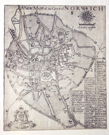
IntroductionBetween Brazen Doors and the gateway at Ber Street was the second longest single section of the defences...some 560 metres with five intermediate towers. [1] The towers were regularly spaced and, although all the towers were demolished in the 19th century, their positions can be determined with some accuracy from historic maps. Kirkpatrick's map of about 1700 [Norwich Castle Museum 1894.76.1682:F] indicates that the first, the third and the forth tower south of Brazen Doors were circular in plan and the second and fifth tower were rectangular. Although none of the towers survive, two small sections of wall remain behind the long terrace of houses at the south end of Queen's Road. In 1910 these two fragments were at either end of a continuous section of wall some 15 or 16 metres long. A flint boundary wall west of Ber Street, in part incorporated within a 19th-century brick outbuilding, is on the line of the wall and may also contain medieval fabric. In 1958 an inspector from the Ministry of Works reported that there were traces of an internal arch in a piece of wall behind the Pheasant and Cock Public House. Without archaeological investigation it is not possible to say which sections of the Queen's Road wall had arches on the inner side. The Queen's Road section of the wall ran from north west to south east forming the south-west limit of the city. The wall and outer ditch were relatively straight but with their line curving inwards at the south end. Queen's Road, on the line of the medieval lane outside the ditch, and Ber Street, one of the main medieval routes out of the city, converge at a sharp angle of approximately 23 degrees. The Queen's Road ditch curved round to cross the line of the road at a right angle. Just beyond the bridge, the bridge before the gate, the ditch and wall turned sharply to resume their course along Bracondale. This marked change in the alignment of the ditch was to simplify the construction of the arch or arches of the bridge. The modern road actually rises by about 6 metres between the site of Brazen Doors and Ber Street. Natural drainage was possibly down the slope to the east, to the river, but the ditch presumably drained to the south although it is now impossible to reconstruct the profile of the ditch and its incline. |