City walls survey
28 Queen's Road
|
|
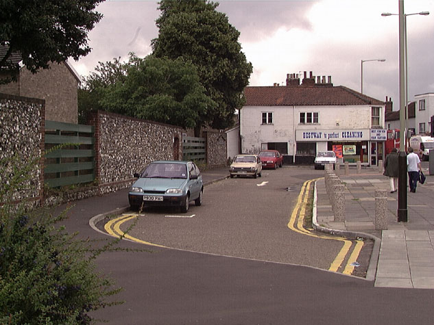
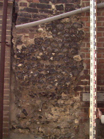
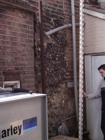
Documentary EvidenceThe 14th-century Customs' Book omits Brazen Doors and simply records that there were 307 battlements between St Stephen's Gate and the gateway at Ber Street. In the middle of the 15th century, the Broad Tower between Brazen Doors and Ber Street was leased to a tenant. 'A certain broad Tower in the Walls of the City, opposite St Katherine's Church for 10 years at 2s. per ann.' [Lib. Comp. Thes. Civ quoted in Fitch page 5] This must have been the second tower shown clearly on Kirkpatrick's map to have been not only rectangular but much wider than many of the other towers. On the 30th May 1660, 'The said Broad Tower was ordered to be leased out to Mr Will Tooke, Alderman Robt Howard, Jeosaphat Davy, and other Inhabitants of All Saints' parish, for 21 years at 2s per ann.' [Fitch page 6] What was the tower used for and why were so many tenants involved in the lease? In 1727 an order was issued for the wall between Brazen Doors and Ber Street to be rebuilt.[SMR NF20] It is not clear why the rebuilding was necessary or how extensive that rebuilding was but the document does specify that the newly rebuilt parts were to be 3 feet thick, 15 feet high and with foundations a 'full' 2 feet deep and 4 feet thick. The work was to be finished in three months and was to be paid for at a rate of 3 shillings per yard. [Fitch page 7] The time proposed for the work would imply that, in fact, much of the wall was rebuilt. This work was undertaken the year after the gateway at Brazen Doors was rebuilt. The Norfolk Annals for January 18, 1807 referring to Ber Street, mention 'A length of about 40 yards of the city wall' falling 'with a tremendous crash'. Following this, the Grand Jury 'made a presentment, in which attention was called to the dangerous state of the wall.' [Annals, volume 1, page 54] An entry in Blyth's directory of 1842 mentions this same collapse, noting that 'On January 18th, 1807, a great part of the wall near this gate [Ber Street] fell with a tremendous crash, killing four cows which were in an out-house, but fortunately no person sustained any injury. The ground has since been cleared and built upon.' [Blyth, page 4] It is not clear exactly where the section of wall was, but the Queen's Road section nearest to the Ber Street Gates seems likely as the wall beyond Ber Street to the east survives and in any case the houses there were larger and unlikely to have had cow byres. Map evidenceBoth Cunningham's view of 1558 and Cleer's map of 1696 show just four towers between Brazen Doors and Ber Street Gate. King's map of 1766 shows just one tower in this section, the last tower before Ber Street. Both inside and outside the wall was open land with few buildings. Hochstetter's map of 1789 indicates the towers but suggests that by that date the ditch had been filled in for the map appears to show a broad lane outside the wall for much of the length. Some buildings are shown against the wall at the south end. By 1830, the date of the map by Millard and Manning, there was still little building near the wall on the inner side except at the south end around the church of St John. The large triangular area inside the wall, known as St Catherine's Close, was still open land. However, there appear to be houses against the outside of the wall, over the site of the ditch, all the way from Upper Surry Street (sic) to Finkel Street. Note Surry Street is now called All Saints Green and the name Surrey Street is given to the road running at an angle from All Saints Green to St Catherine Plain. The wall had been breached and a section demolished at the end of Finkel Street to form an open square called 'Catherines' Plain and there were houses built on both sides of the wall between Finkel Street and Ber Street. The map suggests that the wall and towers between Surry Street and Catherines Plain were still standing and there was a section of wall surviving south of St John's church, running up to Ber Street. [28-01 Map] By 1885, the date of the first edition of the Ordnance Survey map, most of the wall and all the towers between Surry Street and Catherines Plain had gone. There were a series of widely-spaced houses in pairs or short terraces built over the line of the ditch and fronting onto Queen's Road. A post-war administrative map of the city marking 'The Chief Buildings of Historic and Architectural Interest before 1850' marks a section of wall surviving just north of St Catherine Plain. This would appear to be about 25 metres long and was immediately behind two houses in the long terrace then facing onto Queen's Road...behind the 7th and 8th houses in the terrace from the south end. There is no date on the map but it pre dates the construction of the dual carriageway along Chapel Field Road and Queen's Road so must have been compiled before 1970. There is now no trace of this section of the wall above ground. One of the houses in the long terrace south of Finkel Street is dated 1864. Initially the medieval wall behind these houses survived with the north or gable wall of the back kitchen blocks built up to and over the wall. The wall is shown on a survey map published in the 1910 report. [2]However, the wall was slowly but systematically removed as the yards of the houses were extended and now only two short sections survive, one in the rear wall of the laundry at the west end of the terrace and one stub of wall behind number 222 Queen's Road. General descriptionSouth of the junction at All Saint's Green, Queen's Road is now a busy dual carriageway. This is constructed over the line of the outer ditch. The site of the wall is covered by either narrow car parks running parallel to the road or by sections of broad grass verge. [3] At the south end of the section, before Ber Street, the road narrows and on both sides there are rows of small terraced houses dating from the early and mid 19th century. The houses on the north side of the road are built over the line of the ditch and small fragments of the wall survive in the narrow yards behind these houses. 216 Queen's RoadA stub of the wall survives in the rear wall of number 216 Queen's Road. [28-02 216 Det] The building, at the west end of the terrace, dates from about 1860 and is now a laundry. The surviving section of the city wall is in the rear or north wall and can be seen from the back yard of the property buried in the north-east corner of the rear range. [4 & 5] The wall is 3.8 metres high and just over a metre wide. [6 & 7]Inside the building it can be seen in the back corner of the rear workshop on the ground floor where it is plastered and painted. On the first floor it rises above the floor for just 1.2 metres and is at present buried within a cupboard across the gable end that also forms a heat and dust vent for the laundry equipment below. The wall at this level is rough exposed (i.e. unplastered) flints but painted dark green. The survey of the wall showed that it is 1.5 metres thick. 222 Queen's RoadA second section of wall survives buried within the end or north gable of the two storey kitchen and bathroom block of number 222 Queen's Road and is again visible from the rear yard. It survives up to the top of the ground floor. When this building was refurbished in 1999, part of the top of the wall was said to have been removed. In 1910 these section were at either end of a continuous run of wall shown on the plan published in the report by A Collins. 1a BracondaleAt the west end of Queen's Road, close to the site of Ber Street Gate, a third section of flint wall survives on the line of the medieval defences. [28-03 Plan] This now forms the back wall of a 19th-century outbuilding, possibly a carriage shed, behind 244 Queen's Road and now part of that property although curiously it has the separate address of 1a Bracondale. In 1910, in the map published with the survey of the city walls, the buildings are shown much as now though there appears to be a small lean to or addition to the front of 1a forming a much smaller yard with a gateway right on the corner. The brick carriage house is just over 9 metres long and 4.5 metres wide. There are two rooms on the ground floor. The larger room to the west is now glazed across the front towards the yard but evidence of chamfers and stops on the beam across the front indicates that it was originally open with one wide and one narrow bay. This is the arrangement shown on the plan of 1910. The smaller east room contains a modern staircase up to the single first-floor room that is open to the roof. The roof, with three trusses in softwood fixed with square headed bolts, is of a shallow pitch, and is covered with pantiles. All the window and door fittings are modern. On the north or city side of the roof there are prominent brick kneelers and copings. The north wall is a mixture of flint and brick and has been much rebuilt. On the city side the wall steps in at the top of the ground floor and is protected by a double line of pantiles. [28-05 Int Elev] This thicker section stops short of the curved east gable though the reason for this is unclear. In the lower part there are several areas of rebuilding, particularly at the west end where there are the stubs of brick walls cut back. Several areas of facing have broken away revealing the loose mortar of the core. The wall continues beyond the west gable of the block and runs into the brick-built boundary wall of the gardens of the 20th-century flats on the west side of Ber Street. Just before the start of this boundary wall, there is a line of brick headers strengthening the wall near the top. Presumably this is part of the 19th-century work. The upper part of the wall is very badly built with much more patching in brick. This is either the south gable of the range built along Ber Street and abutting the wall and shown on the map of 1873 or it is part of the rebuilding of the outbuilding when it was heightened. On the inside, on the ground floor the wall has been refaced in brick with some flints. [28-04 Ext Elev] This facing appears to support the joists of the first floor. On the first floor the wall was battened out and plastered. This has been stripped away and has revealed that this part of the wall is heavily patched and poorly built with areas of large irregularly set bricks and some large reused stones. Two vertical lines of brick 2 metres and 4 metres from the west end show where cross walls of this building were bonded in to the flint work but have been removed subsequently. The surviving flint wall appears to be on the line of the back wall of the Ber Street Gate, on the inner or city side of the defences. This could only be verified by archaeological investigation. The wall has been much rebuilt and is now in a poor state of repair. In part this is probably because when buildings constructed against the wall were demolished, any facing flints were pulled away. The wall is now only 700 to 800 mm thick and presumably the north wall of the tower, which was four storeys high, would have been at least 1.5 metres thick. Bull Close Road tower is only 7.4 metres high and there the outer walls are 1.55 metres thick. Although no certain medieval fabric survives above ground, the site is very important and so no excavations should be undertaken either in the yard, within the outbuilding or on the city side of the outbuilding without archaeological supervision. Present state: archaeology. conservation and potential excavationsIn 1962 14th-century bricks were removed from this section of the wall [SMR NF261 TG230079]. A cable trench along Bull Lane/Queen's Road in 1997 revealed no archaeological finds, but it is noted in the file that the most sensitive part of the trench was not observed. [SMR NF264]Current work in progress (in 1999) behind Queen's Road near the wall behind the terraces has not revealed evidence of another tower, and shows that the base of the wall does not go very deep, and does not survive below the modern gravel surface. Some modern brick capping was removed from one side of the stub of wall that is still standing here. There was no indication of works associated with Ber St. Gate where access was available. The rubble core was shown to be flint-faced Jayne Bown [NAU, Pers. Comm, November 1999]. Generally, the 20th-century roads and hard landscaping have obliterated any evidence for the wall between All Saints Green and Finkel Street. Some consideration should be given to marking the site of the walls with cobbles as elsewhere but here marking the full width. This would be justified as a reasonable way not only of emphasising the importance of the site of the wall but it would also form a physical link between the important surviving sections of the wall at St Stephens and at Ber Street. Any excavations for services or building work along the line of the wall should be aware of the importance of establishing the precise position, overall size and the plan of the intermediate towers. BIBLIOGRAPHY:Blyth, G.K., The Norwich Guide and Directory (London: R. Hastings; DOCUMENTARY REFERENCES:ARCHAEOLOGICAL REPORTS:SMR NF20 |