City walls survey
32 Carrow Hill and Black Tower
|
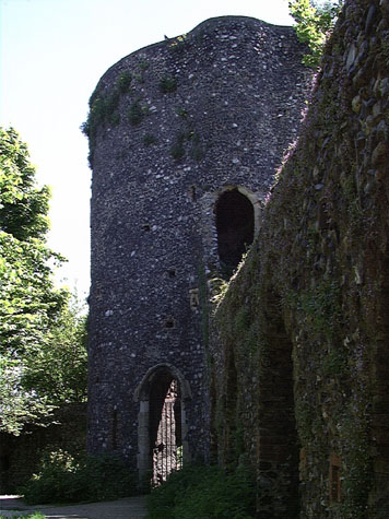
Conservation PlanThe present setting:The wall and tower are set along a high ridge above the river valley. On the outer side is a steep bank dropping down to the road now called Carrow Hill. At the foot of the bank is a high brick retaining wall that is slightly battered and has a concrete capping. The bank itself is densely covered with young trees that were presumably planted to consolidate the bank. Not only do these hide the wall, but ongoing maintenance clearing undergrowth must be difficult and the branches of the trees closest to the wall now overhang the wall and as they grow stronger and thicker may damage the wall top. Historic photographs of the wall and bank without trees looks stark and bleak so some compromise should be sought. The trees should be thinned out and low ground cover planted. If the bank continues to slide then more recent techniques now used to consolidate motorway embankments might be considered. The advice of a specialist engineer should be sought. On the inner side of the wall, the first section is within the gardens of the hostel in Carrow House and is not accessible to the public. The footpath starts on the outer side of the wall at the west end and then at the breach moves through to follow the inner side of the wall to reach the Black Tower. East of Carrow House, the steep slope down to King Street is densely overgrown and there are no clear lines of view down to the river. The trees and undergrowth are well back from the wall but the area should not be allowed to get any more overgrown. Rubbish and weeds particularly nettles between the path and the wall should, ideally be cleared regularly. Close to the hostel, the arches provide sheltered spots for quiet drinking but cans, bottles and carrier bags are either left abandoned in the arches or are stuffed through the loops to collect on the outside of the wall. Landscape report by Christine Boswell:The western end of the wall borders a breedon gravel footpath on the south side and a residential garden on the northern side. There is weed growth on both faces, more on the north side especially moss. On the south side of the wall there is a grass margin approx 600mm wide, mirrored on the other side of the path. This was overgrown at the time of the visit and is a finish which requires regular strimming. Recommendations:
Second section to the Black Tower:The south side facing the road (Carrow Hill) is masked from the road by a line of trees, shrubs and nettles which grow on the steep bank down to the road. The north side of the wall is arched with a 1 metre wide margin at the base of the wall, at present covered with nettles. This margin is mirrored on the other side of the path. At the Black Tower a public bench has been positioned for a view over the River Valley. The bench is already damaged by graffiti. A path and steps approach the tower from Carrow Hill and follows the wall through a wooded area. Although this area masks the wall from the road, it provides a leafy haven and stabilizes the steep embankment. The undergrowth is mostly nettles and brambles. Recommendations:
Potential medium or long-term improvements recommended for the surroundings:The surviving wall and the Black Tower at Carrow Hill are major and little-known monuments. The remains of the city defences here are impressive works of medieval engineering, they are remarkably complete, the towers and walls are strong images of a major aspect of life in medieval Norwich and they are a testament to the civic pride of the citizens. The present pathways and steps provide a pleasant if steep area to walk but are under utilised. The section at Carrow Hill should be seen in conjunction with any long term plans for the wall below the Black Tower, the lower tower, the wall running down to King Street and the wall and the Boom Towers below King Street. The report completed in 1970 suggested linking these areas and at that stage the path up from King Street behind the wall was created and advertising boards on King Street were removed. The longer-term proposal then was to create a narrow band of grass and trees on the outer side of the wall from the west Boom Tower on the river bank to the lower tower. This has never been implemented. The factory site below King Street is still derelict and although the area of land outside the wall above King Street was cleared of cottages, the present hostel for the deaf was built on the site. This area of the defences is so important that it merits being the focus point for a much wider and much more adventurous scheme. With the development of the east bank of the river down to Carrow Bridge, with the major redevelopment of King Street and with proposed redevelopment of the Coleman's site south of the wall there is a distinct shift of interest to this area. European Interreg III funding for walled towns is looking specifically at how to redirect tourists out from historic centres to encourage them to spend longer in the towns they visit and to explore further and in the process spend more locally. Increased tourism alone is not the answer for the future use of the towers and walls here but some funding may be sought on the back of that scheme to enhance the setting. There may also be an opportunity here for sponsorship. Obviously costs and income generation are crucial and a separate feasibility study could be commissioned. Some city events like bonfires in November or periods when the wooded slope was illuminated on summer evenings could attract sponsorship and would echo the way the area was used in the 18th century. In the 18th century the Wilderness was apparently a popular attraction as a leisure gardens. A wider scheme to develop a semi wild park or possibly a nature reserve running down from the hill to include the area of park around the ruin of St Peter's Church might attract more visitors. Pathways and steps could be cleared with open view lines created where appropriate by cutting back trees. The Black Tower should be made the focus for any visits. It would be possible to build a free-standing timber gallery within the tower at the first-floor level simply for the views and an entrance charge with limited opening times might provide the income to merit a display here on the walls and defences. Any display should contain basic facts about the construction of the defences, information about medieval siege warfare, information about the mechanics of building these structures in flint and brick and information about aspects of archery, the city guards or watch and controlling trade in the city. Displays and information should be on simple robust weather-proof panels and the information should be aimed primarily at children and school parties. Archaeological impact assessment:It is unlikely that any archaeological work will be undertaken in this area in the near future as Carrow Hill is not under threat of development and trenches for services and so on are unlikely. If any work is undertaken then, as with many sections, the footings of the wall, the form and extent of an earlier bank, if there was one, and the precise relationship of the wall and tower and the sequence in which they were built should be the focus of any investigation. Conservation Report Summary with Recommendations for ActionImmediate attention
Requires regular monitoring
Long term conservation
Improvements to the settingPriority
Long term
BIBLIOGRAPHY:Blomefield, Francis, An Essay Towards the Topographical History of the See also: DOCUMENTARY REFERENCES:N.R.O. MF/RO 29/3 f. 177 (Liber Albus) ARCHAEOLOGICAL REPORTS:NAU Report 161, 'The Black Tower, Norwich: A Survey' (Robert Smith, HISTORIC ILLUSTRATIONS:Norwich Castle Museum and Art Gallery:Artist Unknown, watercolour, 'Waterfront King Street - Site of Carrow Bridge - the Snuff Tower with the remains of the Windmill on Top', NCM no number Gurney, L, Bracondale Tower, Norwich. NWHCM 1922.135.FAW 52:F Kirkpatrick, John, c. 1720, 'Great Tower upon Butter Hills', NCM 1894.76.1695 Stimpson, Percy E., 'The Black or Governor's Tower Carrow', NCM 1969.557.13:INT |