City walls survey
32 Carrow Hill and Black Tower
|
|
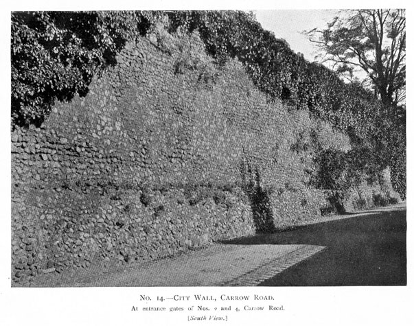
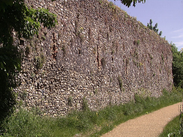
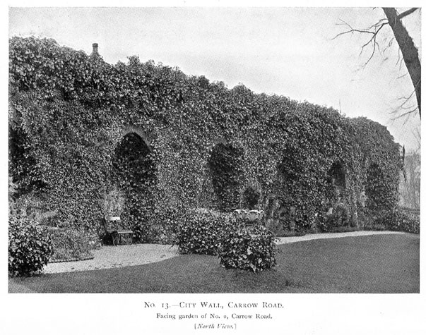
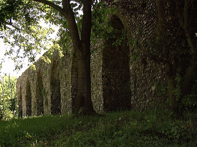
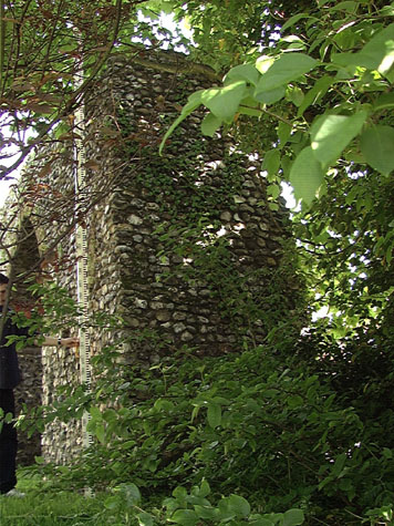
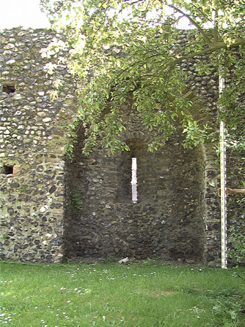
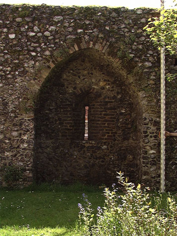
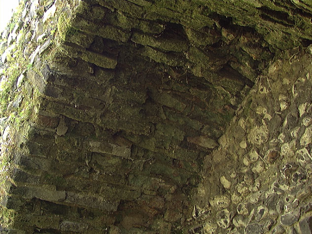
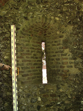
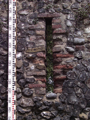
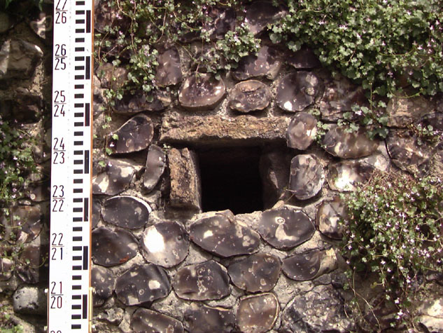
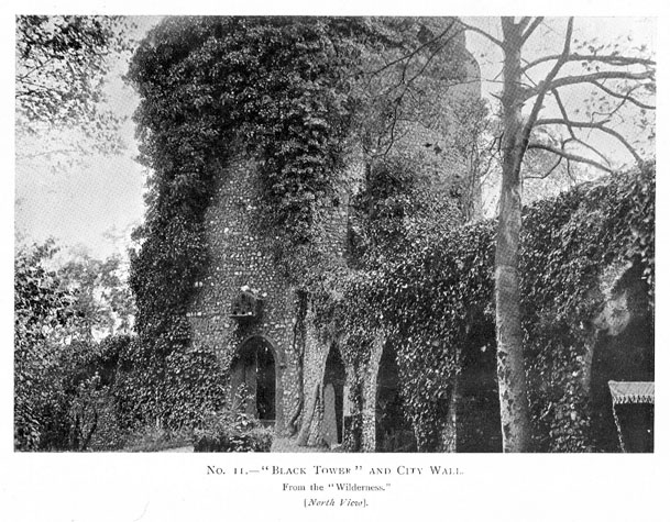
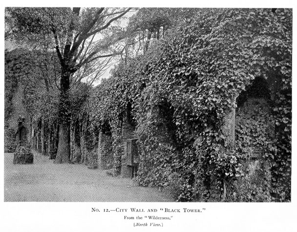
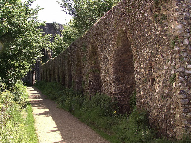
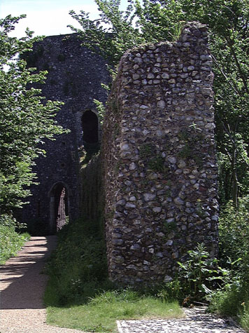
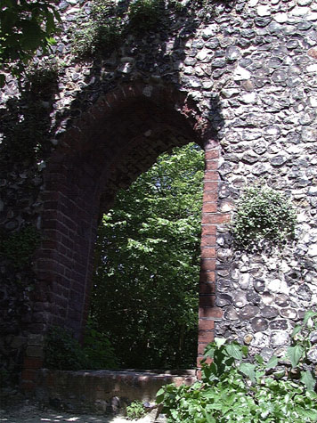
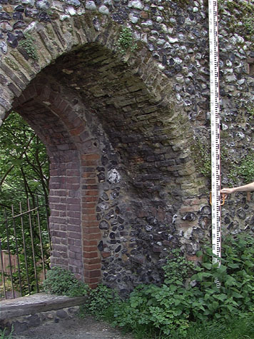
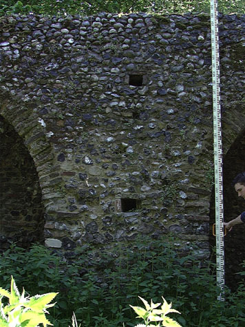
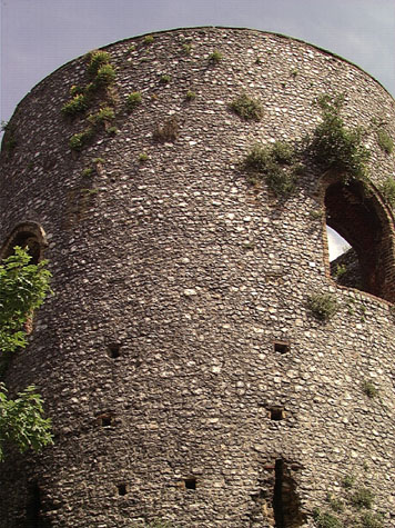
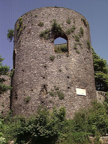
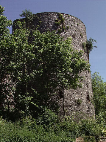
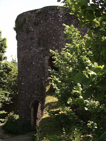
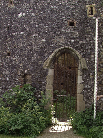
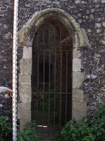
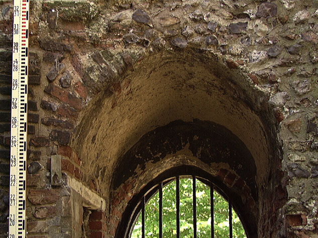
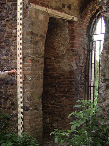
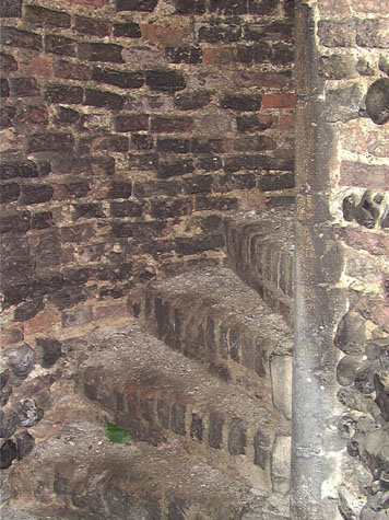
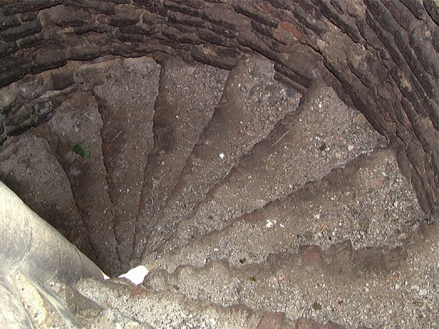
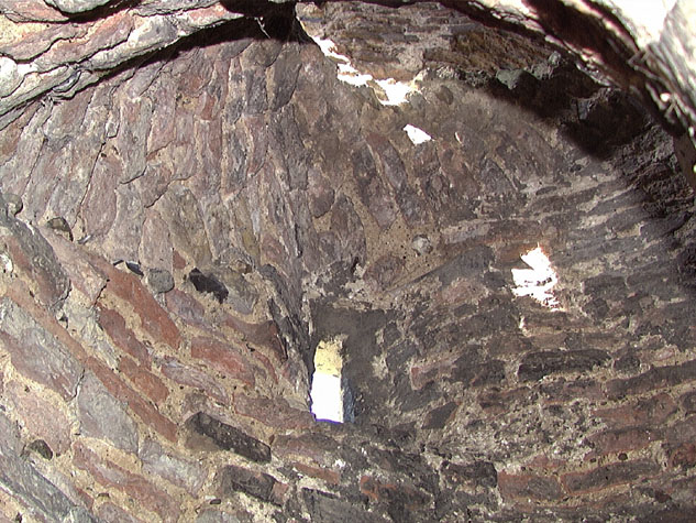
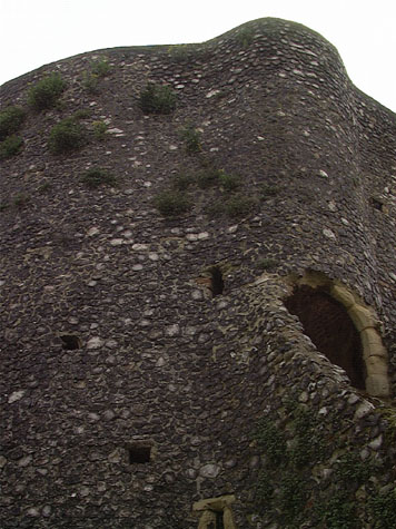
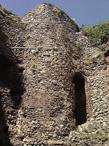
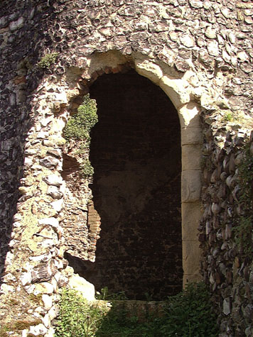
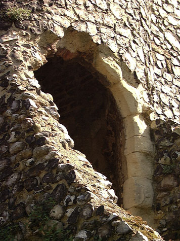
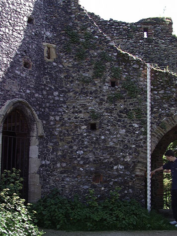
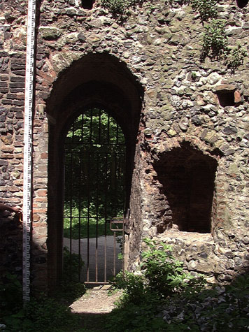
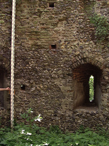
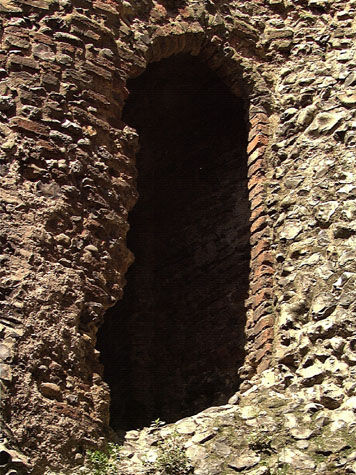
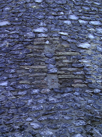
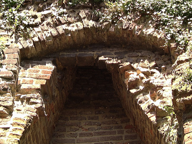
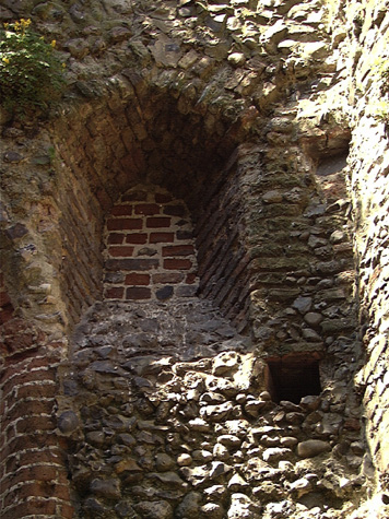
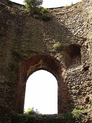
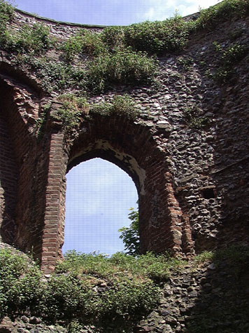
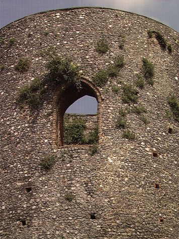
Historical Background ReportGeneral description of the historic fabricThe standing defences at Carrow Hill can be divided into three sections that are obviously closely linked. The first part is the wall and arches in front of the gardens of Carrow House. The second part is the wall beyond the breach, running up to the tower and the third part of defences here is the Black Tower itself. The first part of the standing wall runs west to east from close to the junction of Bracondale and Carrow Hill and is on the north side of Carrow Hill which is a 19th-century road that follows the line of the outer ditch. The wall is 27.4 metres long and stands to almost its full height with the wall walk clearly surviving with the lower courses of a parapet on the outer side. [2 & 3] The medieval ground level survives inside the wall where there are six complete arches of the arcade that supported the wall walk. [4, 5 & 6] These arches are pointed and formed with bricks set with alternating stretchers and paired headers. [7 & 8] Each arch has a spalyed embrasure centrally placed to the arch within the outer face and again constructed in brick. [9 & 10] At the west end there is a straight joint and the first bricks of the springing of a seventh arch that was truncated and partly filled in when the west end was consolidated sometime after the wall was breached here. [32-04 Up Int Elev] It is clear that the arches continued on to the intermediate tower at the junction of Bracondale and Carrow Hill that has been lost. In fact, evidence indicates that there was a continuous arcade from the angle of the wall at Ber Street just east of Ber Street Gate, right through to the Black Tower broken only by the lost intermediate tower...possibly 43 arches in total. The ground level on the outer face of the wall is lower and the bottom metre of the wall is battered out. [32-03 Up Ext Elev] This is not under building but part of the medieval construction. On the outer side the six loops are formed in brick set irregularly. [11 & 12] There are two levels of putlog holes lined in brick [13] indicating that the main part of the wall was built in three ' lifts' and the parapet would have been raised as a fourth stage of building and would have been just under 2 metres high with embrasures and merlons forming battlements. These too would have been formed in brick but with the main part of the parapet in flint. At the east end of the wall, immediately before a breach of 20.5 metres, there is part of an eighth arch but completely filled in with flint work. In the breach, cut through in the 19th century when this part of the wall was demolished, there were a further 6 arches now lost but marked out in cobbles in the grass. The wall running up to the Black Tower is just over 47 metres long and has part of an arch immediately after the breach and 11 complete arches. [14, 15, 16 & 17] The arches and loops here follow the same form as those in the west section. [32-06 Mid Int Elev] The loop in the first arch is now blocked and in the last arch, against the tower, a gateway was cut through the position of the loop to create a route along a pathway below the tower. [18 & 19] The arches are 1.8 metres wide and the piers between the arches are 2.2 metres wide with putlogs placed centrally to the pier and equally spaced vertically dividing the height into three almost equal sections or lifts. [20] The arches are a metre deep in a wall that is 1.8 metre thick overall. The springing of the arches are approximately 1.5 metres above the present ground level and the arches are about 2.8 metres high to the apex in a wall that is just under 4 metres high to the wall walk. [32-05 Mid Ext Elev] Robert Smith has described briefly all the arches and loops listing where brick work has been replaced or repaired. He has also suggested that changes along the length imply that the main part of the wall was built not only in three stages in terms of lifts but may have been divided along the length with three arches constructed at a time. The Black Tower has an external diameter of 10 metres and an internal diameter of 6.5 metres. It stands now 11.2 metres high on the inner side but where the ground drops away on the side towards the ditch is 13.5 metres high. [21, 22, 23 & 24] It would originally have been higher with a crennelated parapet that survived until the 18th century. The tower is faced in knapped and squared flint and loops and windows are generally formed in brick. [32-11 Tow Nor Elev] [32-12 Tow Sou Elev] [32-13 Tow Eas Elev] [32-14 Tow Wes Elev] The tower had two main chambers. It was entered at ground floor level by a narrow but curiously tall door way with an arched head formed in stone in the internal angle between the tower and the wall to the west. [25 & 26] The entrance cut through the wall to form a brick vaulted lobby within the thickness of the wall. Immediately inside the entrance on the south side is a doorway onto a tight spiral staircase leading up to the first-floor chamber. [27, 28, 29, 30 & 31] This staircase turns clockwise with brick steps and a stone newel. It respects the present ground level of the tower. It rises partly within the thickness of the tower wall but also bows outwards and is at the point of the tower where the wall to the west abuts. [32 & 33] There is a doorway from the wall walk into the stair turret just below the level of the chamber floor. That doorway too has a stone surround with a hood moulding though much damaged. [34 & 35] There were eight steps at the end of the wall walk up to the door that were protected by thin parapets on either side. [36] The staircase continued up beyond the chamber to the level of the tower roof and the stair turret stood up above the main parapet as depicted by Kirkpatrick in the early 18th century. [37] The lower chamber had eight sharply angled embrasures with narrow loops, three looking inwards towards the city and five looking outwards over the ditch or along the outer faces of the flanking walls. [38 & 39] The lower storey is tall with what is now an angled offset about 4.7 metres above the floor. Here the wall steps in, the wall of the upper part of the tower being thinner. This offset could have supported a timber floor structure but scars in the face of the wall indicate the webs of a vault with very sharp arches springing from a point 2.7 metres above the floor. [32-15 Tow Nor Sec] [32-16 Tow Sou Sec] [32-17 Tow Eas Sec] [32-18 Tow Wes Sec] Not only does the vaulting appear to be slightly irregular in its bays but the narrowness of the arches of the vaults suggests that there may have been a central pier providing support. The entrance and the projection of the staircase on the west side break the regularity of the vaulting. The vaulting does not respect the position of putlog holes which indicates that the drum of the tower was constructed first and then the form work inserted for the construction of the vaulting. Much of the upper chamber was altered in the 18th century but the two main medieval features survive with a narrow arched and chamfered doorway in brick on the west side leading to the staircase [40] and immediately to its north a substantial brick fireplace. This has herringbone brick work across the back but has lost its hearth and the lintel or arch of the opening and much of inner face of the flu has collapsed. [41 & 42] In the 18th century the chamber was extensively altered by the insertion of four large round-headed windows. [43, 44, 45 & 46] These have surrounds formed in brick headers and photographs and drawings show that the windows had heavy wood frames with a mullion and Y-shaped tracery. These have all gone though the rebate for the frames survive. The windows seem to have had semicircular sills forming a walk-in area within the splay. It is not known if these openings directly replaced loops or replaced larger but secondary medieval openings. The early 18th-century drawing of the tower by Kirkpatrick does show an arch-headed window on the north side which could be medieval. It should be noted that the Cow Tower, built on a similar scale, appears to have had simply loops to light the large upper chamber. There are original loops surviving on the Black Tower but blocked on the outer side. The sills of these loops are some 1.6 metres above the offset and too high now to be used. That suggests that the offset may have been contrived or lowered when the vault was demolished and the floor constructed some 500mm below its medieval level. That would certainly fit better with the back crease of the hearth and the threshold of the doorway onto the staircase. The upper part of the tower has been lost so it is not clear how the roof was constructed. The fact that the stair continued to the parapet level indicates that there was at least a parapet level walk. The surviving part of the upper wall sets back on the inside just a metre below the skyline and this ledge would almost-certainly have provided the support for the roof or platform structure. A newspaper report of a fire on the roof in 1833 caused by lightning indicates that the roof covering then was thatch. This may have been a cheap replacement for lead or tiles but medieval documents record also that several of the gates were thatched in the 14th century. The report also implies that there were rooms on three levels in the tower at that stage (see below). A small blocked opening with an arched head in brick just below the skyline on the east side of the tower indicates that there was some sort of feature here at parapet level though its function is unclear. Was a wider opening required to look down from this level towards the river? Documentary evidence:In the early 13th century, the land inside the wall was held by a priest called Nicholas de Berstrete. About 1216 he granted the land to one Sibrand Prat for 30 shillings. This included part of the land
This was a very large piece of land covering all the steep hillside from Ber Street Gate to King Street and everything south of that. The document shows clearly that the city certainly extended as far south as Conisford Gate by the early 13th century and there was already a ditch marking the city limit which presumably followed the present course of the wall down Carrow Hill. It is also interesting that although Boteler owned the property in the 12th century his name survived for Carrow Hill was referred to as Butlers Hill until at least the late 19th century and the Black Tower was variously referred to as Botelier's Tower or Butler's Tower. Ann, the daughter of Sibrand granted this property, to the Church of St Mary along with all her tenements in the city and a mill 'before the Gates of Berstret.' The Black Tower was also known as the Governor's Tower, apparently because it housed a military commander during a siege. [Blyth, page 5] In 1451 and 1481 the Agistment for the Walls records that North Conesford Ward were responsible for repairs to the tower. [Liber Albus, f. 177; Hudson & Tingey, vol. II, pages 313-15] 'On the top of Butterhills stands a fair large and lofty round tower, all faced with black flint, having a decayed watch tower or turret on the top of the staircase, which is on the N. W. side of the tower. At the Assembly on St. Matthews day, 33 Eliz. 1591, Mr. Thos. Pecke, Alderman, promised to give �4 towards the covering of this tower, which is called Black Tower.' [Fitch, page 3] In 1625 the tower was made into a prison for 'unruly, infected persons.' In 1621 two pest houses were re-erected on the site. In 1630 six houses were erected near to it, as pest houses and in 1636 the Black Tower was again 'made up' owing to plague. [Blomefield, pages 376, 377 and 379] In 1748 Samuel Bruister acquired the land inside the walls on a hundred year lease and appears to have opened a pleasure garden here. [Trevor Fawcett, article on Norwich Pleasure Gardens in Norfolk Archaeology] In 1768 public breakfasts were held in the gardens and in the evenings the walls were illuminated and there were illuminated walks. By 1771 the walls and the gardens were privately owned and the Black Tower was called Mackarel's Tower. Some time before 1789 the tower was converted into a snuff mill ... Hochstetter's map of Norwich of 1789 identifies it as such. [NAU Report 161, page 2] A tablet dated 1817 attached to the Black Tower records the conversion of part of its surroundings to public gardens. [SMR NF26487] In July 1833,
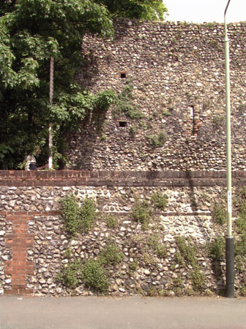
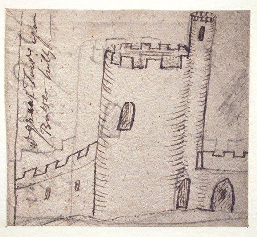
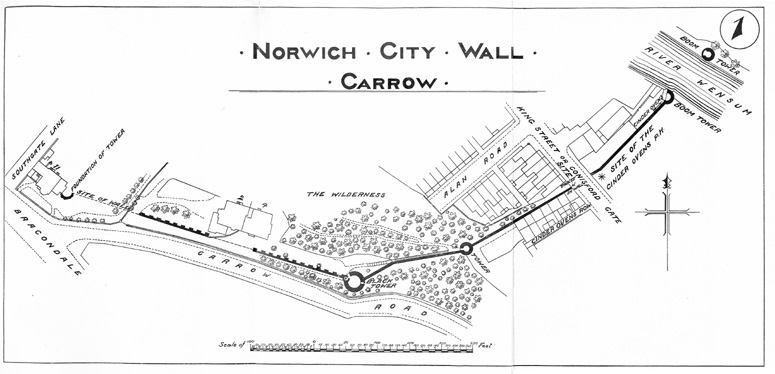
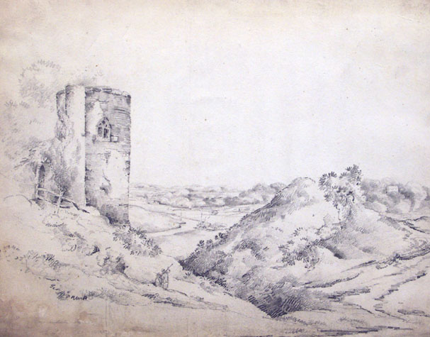
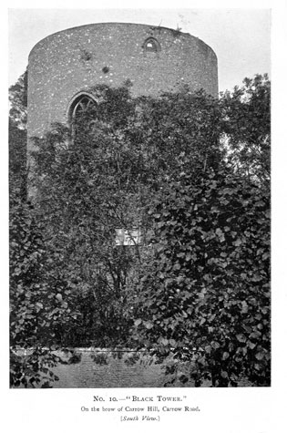
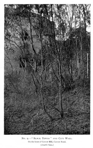
Map evidence:Early maps show that the wall and all the intermediate towers between Ber Street and King Street survived until the late 18th century. There were no buildings on the line of the ditch and no buildings inside the walls. On King's map of 1766, the Black Tower is identified as the Earl of Buckinghamshire's Tower. Carrow Hill House, or at least the first house on the site, was built between 1766 and 1789 for it is shown as a long narrow block immediately behind the wall on Hochstetter's map of 1789. On that map the Black Tower is identified as a Snuff Mill. The outer ditch running down Carrow Hill was dry and was open land with a pathway winding down from Bracondale to King Street at a point just outside the gate. There were gardens laid out against the wall on the lowest section of the wall below the lower tower. Millard and Manning's map of 1830 shows a road running down Carrow Hill, down the line of the ditch. This is said to have been constructed in 1817 and continued across the line of King Street to a new bridge south of the Boom Towers. By 1873, the year Morant's map was published, the road down Carrow Hill was called Butlers Hill. Both the large house south of Southgate Lane and Carrow Hill House in its present form had been built for they are shown on that map. The wide breach in the wall immediately in front of Carrow Hill House had been created by demolishing a section of the wall. The house was built close to the wall because the plot is tightly confined by the steep drop immediately beyond the house. In fact the house is partly terraced out over the slope at the back. By 1885, the year of the first edition of the Ordnance Survey map, the wall and tower on Bracondale north of the surviving section had also gone and the wall and the landscape were much as now. The hillside below Carrow Hill House, running down to St Peter's Church and King Street, was then called the Wilderness. The steep slope was laid out with terraced paths and narrow flights of steps. By 1910, when a map of this section was published in the report on the walls by A Collins, Butlers Hill was called Carrow Road. [1910 report map 1 opposite page 12] Its name was changed to Carrow Hill later in the 20th century. By 1910 there were steps set out inside the wall running down the hill beyond the Black Tower. [47] Historic views and historic photographs:John Kirkpatrick's drawing of the 'Great Tower upon Butter Hills', [Norwich Castle Museum 1894.76.1695] although otherwise unnamed is of the Black Tower, rather than of the lower tower. It shows the tower, with the taller stair turret adjoining to the right and with parts of the wall visible to left and right. The first arch in the wall to the west of the tower is included and the line of the wall walk is shown clearly with the crenellations of the outer parapet. The wall down to the lower tower has battlements but no indication of a wall walk. The drawing dates from the first quarter of the 18th century and shows one large arched window to the chamber on this inner side. The sketch by L Gurney [NWHCM 1922.135.FAW 52:F] entitled Bracondale Tower presumably dates from the 19th century and is a much more romanticised view with the tower framing the view from the west down a heavily wooded valley to the river beyond. [48] The arch through the wall and steps down to the ditch are shown to the left of the tower and the upper window on this side is shown with Y-shaped tracery presumably in wood set within the brick arched opening. The drawing indicates that part of the battlement on the top of the tower survived. The same wooden window frame and tracery is shown in the window on the south-east side in the photograph published in the 1910 report. [Collins, 1910, plate 10] The photographs of the wall to the west of the tower [plates 11-14] show those sections much as now though heavily covered with ivy. [49 & 50] Archaeological reports:In 1971 some sherds of seventeenth-century pottery were dug up from just under the surface inside the city wall near the tower. [SMR NF51] CONDITION SURVEYList of known repairs:The report on the walls in 1970 states that there were serious cracks at the base of the Black Tower and recommended remedial work. Extensive repairs to the tower were undertaken in the early 1990s. When the tower was scaffolded, the structure was examined by the Norfolk Archaeological Unit and analytical reports were produced by Robert Smith. These reports include detailed assessments of the flint work and surviving brick work. They were written over several years and are reproduced in the appendix:
Summary of present condition:The walls and tower are in a very good state of repair and in the medium term should need little work apart from regular maintenance to avoid major problems Principal conservation problems:However, there are several problems that should be tackled now before they develop and require more major work.
|