City walls survey
33 The Wilderness Wall and Tower
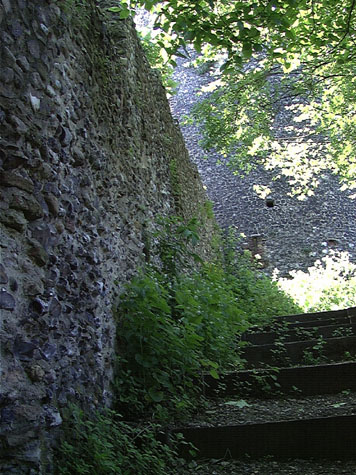 [24] View on the inside of the wall looking up towards the Black Tower 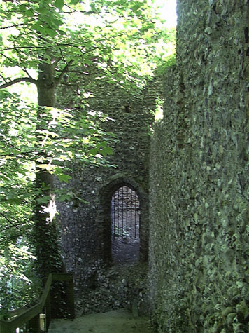 [25] The doorway into the lower tower. |
Conservation PlanThe wall and lower tower and the setting here is of considerable value. Any scheme to enhance the setting or any proposal to draw more visitors to the monument must be co-ordinated with any plans for the Black Tower above and proposals for the King Street Walls and the Boom Towers below. Any scheme should try, in the medium to long term, to pull together this south section of the defences which from the east Boom Tower to Ber Street runs for almost 500 metres. The present setting:The wall and tower are set on a ridge running down from the top of Carrow Hill towards the site of Conisford Gate on King Street. On the city side of the wall is a steep wooded slope with a relatively dense planting of young spindly trees. The pathway down from the Black Tower to the lower tower is hard against the wall for most of the way with steep steps with rough timber risers and gravel treads and an outer wooden rail. All this is in good condition as are most of the people who attempt to climb up it. [24 & 25] On the outer side of the defences a steep slope runs down to Carrow Hill. This was, in effect the outer ditch of the wall, and was man made in part by quarrying. The slopes are now wooded but with steep steps and pathways providing a route from the outer side of the Black Tower skirting close to the wall initially but then cutting out to Carrow Hill. From there a steep run of steps zig zags back into the trees, down to the outer side of the lower tower and from there cuts through the line of the wall to run down to King Street against the inner side of the wall. Landscape report by Christine Boswell:From the Black Tower to the lower tower the Breedon gravel path continues. To the north occasional glimpses of views across the valley can be seen between the tree canopy of the growth on the lower slopes. The path is stepped and very steep. A small section of steps adjacent to the lower tower are all timber and when wet, very slippery. The whole walk is very dark from the overhanging trees. There are terraced houses at the bottom of the walk to the north which are shielded by the tree growth. Their privacy should remain. The last section of the walk approaching King Street narrows before it widens to the pavement. Again it is very dark and unwelcoming. There are not any signs or information boards indicating where the path leads to. Recommendations:
Potential medium or long-term improvements recommended for the surroundings:See the report on the Black Tower Archaeological impact assessment:Archaeological excavations on this section are not a priority and the wall and tower are not under threat. However, any work on consolidating or underpinning the wall, if that should be necessary, could provide information about the footings of the wall and details about the form of the base of the tower on the outer side. Elsewhere, the towers appear to have stepped outwards at the base on the ditch side, well below the internal ground level, with a chamfer at about soil level on the slope of the ditch. The substructure of the lower tower must have been quite an engineering achievement. As there is no indication that the massive balk of the tower has moved down the slope, it is possible that a solid platform was cut into the hillside. Archaeological excavations might also determine how much of the ridge and the ditch are part of the natural topography of the hillside. There were extensive medieval quarries to the south and along the side of the river valley to the north so much of the ridge and ditch may actually not be natural. As elsewhere, the gate is mentioned in documents considerably before the accepted date for the construction of the flint wall and towers ... the earliest known reference to Conisford Gate is in 1175. Again, this suggests the possibility that an earlier bank and ditch preceded the surviving wall on the same line and it also means that the towers may pre date the wall if only by a few years. Archaeological digs across the line of the wall below the tower and examination of the footings if the wall above the tower has to be underbuilt on the inner side could provide vital evidence to tighten up the interpretation of this section of the wall. Conservation Report Summary with Recommendations for Action1. Immediate attention
2. Requires regular monitoring
3. Long term conservation
Improvements to the settingPriority
Long term
BIBLIOGRAPHY:Blyth, G.K., The Norwich Guide and Directory (London: R. Hastings; DOCUMENTARY REFERENCES: HISTORIC ILLUSTRATIONS:Norwich Castle Museum and Art Gallery: |