City walls survey
33 The Wilderness Wall and Tower
|
|
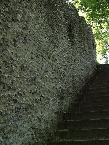
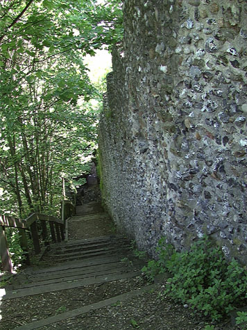
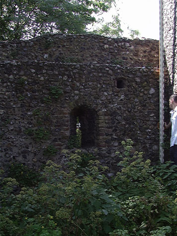
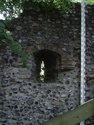
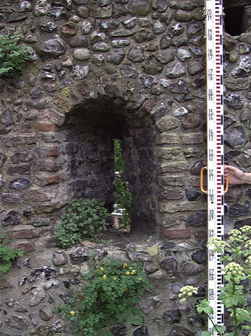
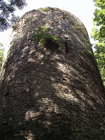
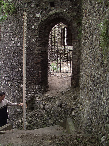
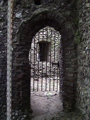
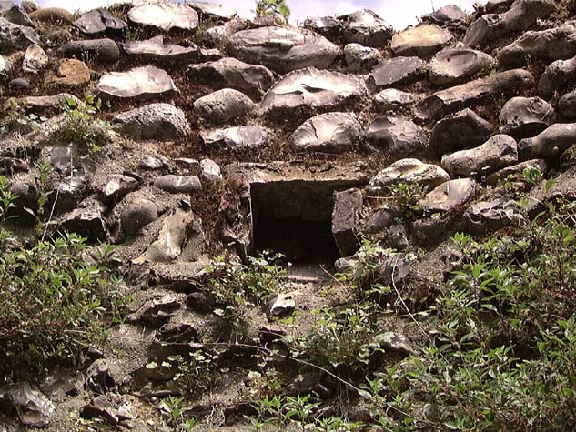
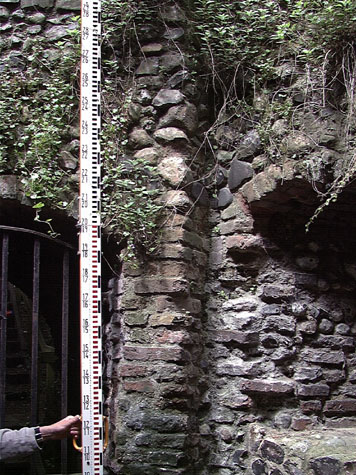
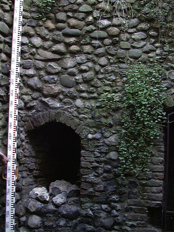
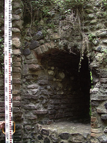
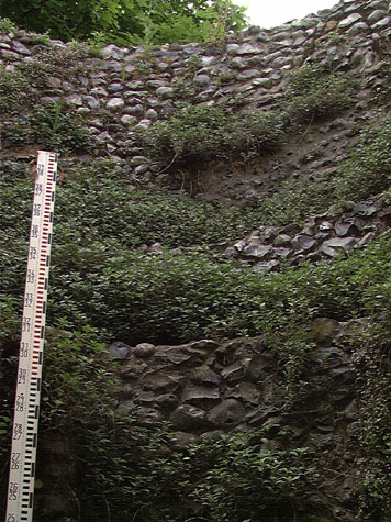
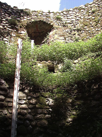
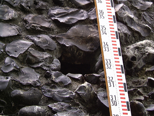
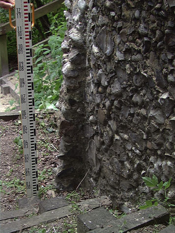
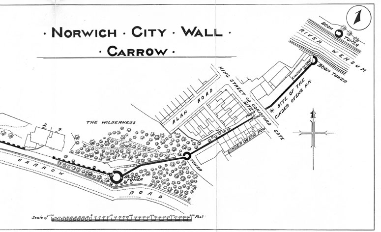
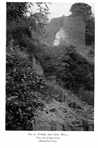
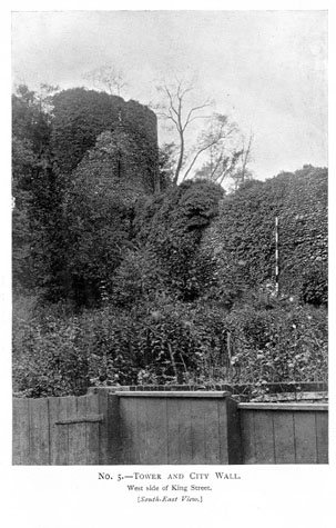
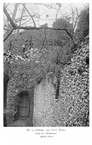
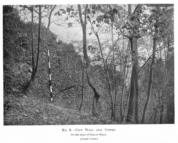
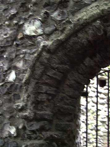
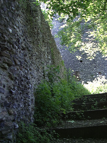
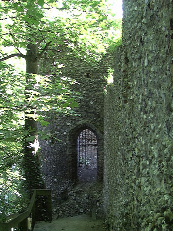
Historical Background ReportGeneral description of the historic fabricThe Black Tower and the lower tower are 48 metres apart and in that distance the ground level drops by 16 metres. [2 & 3] In fact the slope is so steep that the ground drops a further 6.7 metres from one side of the lower tower to the other. The wall descending this steep slope between the towers is angled inwards on plan and is at most 1.5 metres thick. [33-01 Plan] The steep gradient of the slope of the ridge meant that the wall was constructed without arches on the inner side to support the wall walk. The only section of the wall where there are arches that step down with the gradient of a slope are at Barn Road [report 16] and there, in comparison, the slope is very gradual. There are, nevertheless, loops in the wall here though widely spaced with two on the upper part and four after the change of alignment. These have flattened arched brick heads to the inner side of the wall and the jambs of the embrasures and the outer edges of the loops are in brick. [4, 5 & 6] The report on the wall, produced by Robert Smith in 1992, sets out which of the bricks are original and which have been replaced. The loops are spaced regularly along the wall about 8 metres apart except for a marginally longer space between the second and third loop at the angle of the wall. [33-03 Wall Ext Elev] [33-04 Wall Int Elev] These loops are now set too high in the wall but the ground level inside the wall is lower than when the wall was built with as much as 1.5 metres of the footings exposed in the centre of the wall. It is also possible that earth was built up in front of each loop to form a simple level platform. The wall walk on this section was narrow but there is clear evidence for an outer parapet. There is no evidence in the towers for doorways leading out from the towers onto this wall walk so access must have been by ladders propped against the inner side. There are brick-lined putlog holes along the whole length of the wall. At the east end, close to the lower tower, these form a rational pattern with a series of stepped platforms but at the west end, closer to the Black Tower, the arrangement is less rational and it is difficult to see how the scaffold platforms were set up. In the upper part of the wall there is one inserted gateway that is now blocked. The shallow arch of the opening has a double line of headers and the sides of the opening were crudely formed with some bricks. This gateway is presumably one of the entrances to the pleasure gardens and probably dates from the late 18th or early 19th century. The tower has an outer diameter of 6.3 metres and, with thick outer walls, the internal diameter is just 3.3 metres. [33-05 Plan] Because of the steep slope of the site, the tower is just over 6 metres high on the up-hill side, where there is a doorway into the tower, but over 12.5 metres high on the lower side towards King Street. [7] [33-07 Tow Sou Elev] [33-08 Tow Nor Elev] The doorway is arched with chamfered brick jambs and the remains of a hood moulding in moulded or rubbed brick. [8 & 9] The ground plan of the tower is asymmetrical with a flattened inner side around the area of the entrance door on the west side. [10] The door is hard into the internal angle between the tower and the wall running west up to the Black Tower. [11] This flattening or bowing out of the wall line stops with a sharp return back immediately north of the doorway and south of the doorway includes the first loop that looked back along the outer face of the wall, up towards the Black Tower. [33-10 Tow Wes Elev] The reason for the thickening out of the wall on the west side is unclear. On the ground level there are four loops including the loop above looking back up to the Black Tower. [12] There is a comparable loop on the east side looking down the outer face of the wall running down to King Street. A third loop looks straight out to the south and a fourth loop looks north into the city. [13] It has been suggested that the inward-looking loop indicated that the tower pre dated the wall and had been free standing so that it had to be defended to all sides. It seems more likely that the inner loop allowed a watch to be kept on the river below and the far bank of the river. It is even possible that there was an established procedure for signalling from one tower to another or points within the city that had to be watched for warning beacons. Internally, the space within the tower is now 5.6 metres high although the top of the parapet has been lost and the interior is partly filled with debris which may bring the floor up by as much as 400mm above its medieval level. At the upper level the outer wall has two off sets ... one at chamber floor level and a narrower inset 700mm higher, just below the sill of the loops at the upper level approximately 3.25 metres above the present floor. [14 & 15] Because of the topography, with the land dropping sharply away on all sides and with trees growing hard against the tower it is difficult to look at the external flint work to see if the offsets, which otherwise have no rational explanation, reflect a heightening of the tower. It is probably significant that the lower off set on the inside is at the same level as the wall walk on the wall uphill towards the Black Tower. [33-11 Tow Nor Sec] [33-12 Tow Sou Sec] [33-13 Tow Eas Sec] [33-14 Tow Wes Sec] Topographical drawings of other towers, though no standing evidence, indicate that some of the intermediate towers were the same height as the flanking wall and, particularly where they were semicircular and open on the inner side they can be seen at a basic level as a bowing out of the wall and its walk. That is not to suggest that this tower was open on the inner side but that it simply stopped at the same height as the wall uphill. There could have been a simple timber platform coming off the lower offset and the walls above the offset were thinner as they would have been part of the parapet. If this surmise is correct then the heightening, if that is what it is, would have been a relatively early alteration. The upper part has brick-lined putlogs and four brick-lined loops though here the loops are all on the outer side. There is no evidence to indicate how the two-storey tower was roofed. On either side of the uphill wall there are substantial chunks of flint at plinth level acting as bolsters giving the base of the tower considerable strength. It has to be assumed that the lowest stage of the tower is solid and that the footings of this were cut into the slope. There is no evidence to suggest that the tower is unstable or has ever slipped or shifted down the slope. In fact several reports have suggested that the wall above the tower is slipping and is only prevented from moving down the slope by the tower. The outer face of the tower has a regular pattern of putlog holes indicating that there were 7 stages to the scaffolding on the down hill side. On the south side, the lower putlogs, below the ground-floor floor level are not lined with brick. [16] On the east side of the tower [33-09 Tow Eas Elev] is the scar of the wall that continued down towards King Street. [17] This wall was 1.3 metres wide and there is an obvious outline of the thin outer parapet and the internal wall walk surviving. As the wall walk is some 8.5 metres below the top of the tower ... that is well over 2 metres below the floor level inside the tower ... there can have been no access to the wall walk from within the tower. There is no sign of a blocked doorway. The way the flints of the demolished wall have been plucked out suggest that the wall was not butted up to the tower but the two were an integral construction. Documentary evidence:There are remarkably few historic documents for this section of the defences. In part this is because this area of the city was sparsely built up and elsewhere most medieval documents that survive are related to the purchase or sale of property close to the wall. In the early 13th century, the land inside the wall was held by a priest called Nicholas de Berstrete. About 1216 he granted the land to Sibrand Prat for 30 shillings. This included part of the land
This was a very large area covering all the steep hillside from Ber Street Gate to King Street and everything south of that. The document shows clearly that the city extended as far south as Conisford Gate by the early 13th century and there was already a ditch marking the city limit which presumably followed the present course of the wall down Carrow Hill. It is also interesting that although Boteler owned the property in the 12th century his name survived for Carrow Hill is referred to as Butlers Hill until at least the late 19th century and the Black Tower was variously referred to as Botelier's Tower or Butler's Tower. Ann, the daughter of Sibrand granted this property, to the Church of St Mary along with all her tenements in the city and a mill ' before the Gates of Berstret.' The wide deep ditch down Carrow Hill does not appear to be a natural feature. The ridge on which the Black Tower and the lower tower stand appears to continue on the south side of the road though the implication of this ditch being man made would involve the removal of huge amounts of material. In part the dilemma is resolved by historic documents. There was a lime kiln in the ditch outside the walls in the 14th century. About 1322 (15th Edward II)
Presumably it was the workings of this quarry and kilns that excavated the deep broad profile of the ditch or valley running down from the ridge to the river outside the wall. In 1748 Samuel Bruister acquired the land inside the walls on a hundred year lease and appears to have opened a pleasure garden here. [Trevor Fawcett, article on Norwich Pleasure Gardens in Norfolk Archaeology] In 1768 public breakfasts were held in the gardens and in the evenings the walls were illuminated and there were illuminated walks. By 1771 the walls and the gardens were privately owned and the Black Tower was called Mackarel's Tower. Blyth's directory of 1842 describes this stretch of wall and tower as `a good specimen of the ancient manner of fortification. On the walls ascending the hill is a tower.' [Blyth, page 5] It is obvious that this is the tower referred to, as he mentions that the next tower along is the Black Tower. Map evidence:Early maps show that the wall and all the intermediate towers between Ber Street and King Street survived until the late 18th century. There were no buildings on the line of the ditch and no buildings inside the walls. However, the maps do provide some interesting evidence about changes to the landscape around the walls and towers. On King's map of 1766, the Black Tower is identified as the Earl of Buckinghamshire's Tower and on Hochstetter's map of 1789 it is identified as a Snuff Mill. The outer ditch running down Carrow Hill was dry and was open land with a pathway winding down from Bracondale to King Street at a point just outside the gate. There were no buildings along Bracondale apart from those immediately outside Ber Street Gate. There were also buildings on either side of Conisford Gate at King's Street and gardens laid out against the outer side of the wall on the lowest section below the lower tower. In the late 18th century and in the first quarter of the 19th century there was extensive new building work south of the city beyond the walls and gates. Houses were built along Bracondale. Houses, factories and wharves were built between Conisford Gate and Carrow Abbey and about 1817 a new road was constructed running down Carrow Hill, cutting across King Street and leading to a new Bridge over the river south of the Boom Towers. All these changes are shown on Millard and Manning's map of 1830. The ridge on which the wall and towers stand is too steep for any of these changes to have really impinged. By 1873, the year Morant's map was published, the road down Carrow Hill was called Butlers Hill. By 1885, the year that the first edition of the Ordnance Survey map was published, the hillside below Carrow Hill House, running down to St Peter's Church and King Street, was called the Wilderness. By 1910, when a map of this section was published in the report on the walls by A Collins, [18] Butlers Hill was called Carrow Road. [map 1 opposite page 12] Its name was changed to Carrow Hill later in the 20th century. By 1910 there were steps set out inside the wall running down the hill beyond the Black Tower. Historic views and historic photographs:A pencil and water colour drawing by Harcourt Bosworth in Norwich Castle Museum shows the lower tower to the left, with trees and shrubs to the front and right hand side of the tower. Some ruin of the wall is visible. The top of the tower is without battlements. [NCM 1922.135. BH 92:INT] The gate is not visible. The date is uncertain in the catalogue (1805 or 1905) but given the lack of gate and the dilapidated state of the tower and wall the date must be 1905. Photographs of the tower and the wall up to the Black Tower [19, 20, 21 & 22] were published in the report of 1910. [Collins, 1910, plates 5-8] The report states that at that stage the south side of the tower was covered in thick ivy and the outer face of the wall and tower were crumbling badly particularly along the top. [Collins, 1910, page 19] The map published in that report [Map 1] shows the wall from King Street running up to the east side of the tower without a break. Archaeological reports:A report on the lower tower written by Robert Smith was produced by the Norfolk Archaeological Unit in March 1992. This is reproduced in full in the appendix. CONDITION SURVEYList of known repairs:In 1910 Collins reported that on the wall between the towers, 'the outer face of the wall towards Carrow Road, is in a very bad state of repair over its whole surface, and the top is crumbling away into very irregular heights and outline.' [Collins, 1910, 62-63] It is not clear if any repairs were undertaken at that stage. Collins suggested that the wall was unstable and moving down the slope. It had certainly broken away from the east side of the Black Tower where there was a gap that he recommended should be repaired. A large area of facing flint on the south east side of the lower tower had collapsed and repairs appear to have been completed about 1992. Summary of present condition:The wall and the tower are in good condition apart from a major concern about the exposed footings on the inner side of the wall with loose gravel and soft mortar with few large flints. These footings are vulnerable both to rain water running down the face of the wall and to surface water running down the steps. The modern wooden steps down the inner side of the wall make any repair difficult and under building of the wall is not desirable and nor may it be necessary. The problem may not be serious if water does drain away quickly and the slope is steep. The situation should be monitored to ensure that the weight of the wall and water penetration do not cause the wall to move or lean over to the north. The top of the wall is very irregular and again is vulnerable to water penetration. Here, with a footpath immediately below the wall, falling flints are a serious danger. The wall walk appears to slope outwards to shed water quickly away to the north side and water penetration does not appear to be a serious problem at this time. The wall top must be monitored annually and this could be done in the Spring when self seeded bushes and trees could also be cleared away. Principal conservation problems:
|