City walls survey
34 Wall West of King Street
|
|
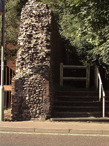
IntroductionThe wall west of King Street drops steeply down from the lower tower on Carrow Hill to the site of Conisford Gate on Kings Street itself. [1] The tower was 57 metres from the gate and over 7.5 metres above it. Much of the wall survives having lost just the upper part abutting up to the tower and a few metres at the east end when the gate was demolished. Over 45 metres of the wall survives standing to the level of the wall walk at a height of about 4.3 metres on the north or inner side towards the city. On the south or outer side of the wall the land dropped steeply down into the wide ditch that ran down Carrow Hill. [34-01 Map] The wall has lost its outer parapet but retains brick lined loops and brick lined putlog holes from the scaffolding set up as the wall was constructed. As the wall drops down the hill so steeply, it was impossible to build an inner arcade. The present wall is only 1.6 metres thick so the original wall walk must have been both narrow and dangerously steep to traverse. There is a scar on the east side of the lower tower where the wall abutted that shows the profile of the wall. There is no evidence for a doorway here at the level of the wall walk and in any case, the steep slope of the hill means that the wall met the tower well below the level of the ground-floor chamber entered from the opposite side. Presumably the wall walk was reached by a doorway out from the upper chamber of the gate or if necessary by ladder further from the gate. The view of the inner side of the gateway drawn by John Ninham about 1790 shows a sloping roof or pentice on the west side of the gate protecting the steps down onto this wall walk. There is no evidence surviving to indicate how either the battlements or the wall walk was stepped down. Cottages were built against the outer side of the wall in the 19th century. Blockings and features in brick remain on the outer face of the wall after these were demolished sometime after 1970. [34-03 Ext Elev] The ground level on the outer side has been lowered and a scar in the flint work shows where the lower part of the wall was battered out. In some parts, the wall has been underbuilt but is generally medieval work implying that the wall had extensive footings and after it was constructed, the ground was banked steeply against the outer side to sharpen the profile of the ditch and make any attack more difficult. The steep slope of the hillside here means that the ditch here would have been dry. With the loss of the gate at King Street and the upper part of the wall parapet and with dense undergrowth around the wall it is now difficult to appreciate just how impressive and imposing the defences of the city must have appeared to those approaching Norwich from the south. From the Boom Tower on the river bank, to the gate and then on up to the Black Tower is a distance of only 160 metres and yet the gate was 8 metres above the level of the river and the base of the Black Tower another 30 metres higher up the hill. |