City walls survey
38 Cow Tower
|
|
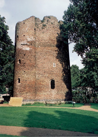
IntroductionCow Tower was not measured or recorded in detail for this survey but a brief report is included here to pull together the main references and provide comparative material. The tall round brick tower [1] is on the west bank of the Wensum, at the sharp bend where the river, after flowing eastwards through the city, turns to the south. [37-01 Map] It is set in a small park, formerly a water meadow to the north of the Great Hospital, and was not part of the original defensive walls and towers although its position could be seen as crucial in defensive terms. The last tower of the north part of the wall was at River Lane up stream and the only defences south of Cow Tower, between here and the Boom Towers at Carrow, was the Gate at Bishop's Bridge. This part of the city was overlooked by much higher ground on the east bank of the river which is here relatively narrow. Cow Tower was also known as the Dungeon. Collins, in his report of 1910, suggests that the tower was 'formerly used as a toll-house by the Prior and Church, then as a prison for the jurisdiction of the Cathedral, and was later assigned to the Great Hospital. By 1378 it had lapsed into ruinous condition, and in that year was conveyed to the City forever, who completed its rebuilding in 1390.' [Collins 1910 page 59 quoting Blomefield, Part II page 402] |