City walls survey
10 St Martin at Oak Wall Lane
IntroductionReport
Conservation Plan
Photographs
|
|
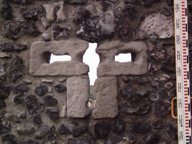
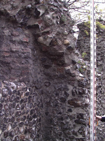
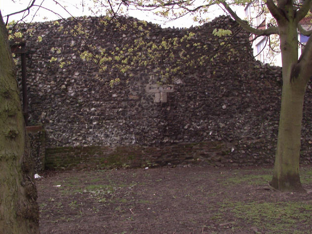
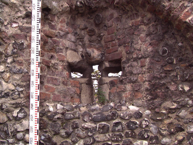
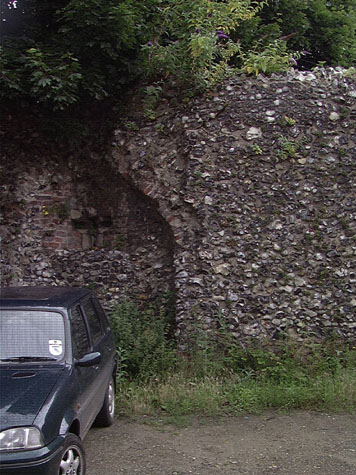
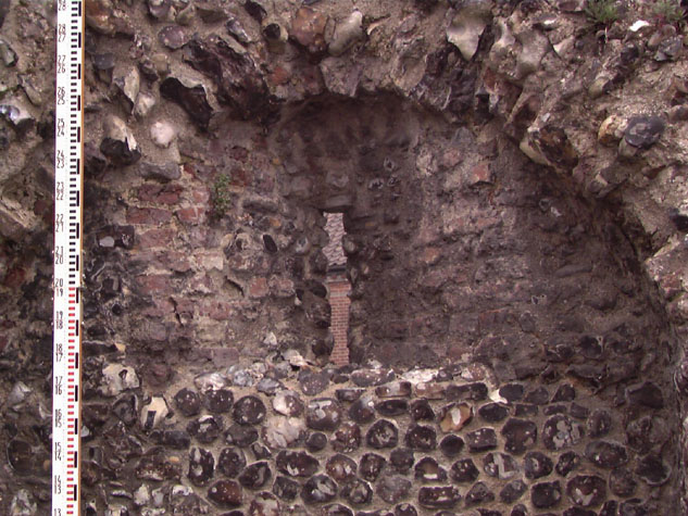
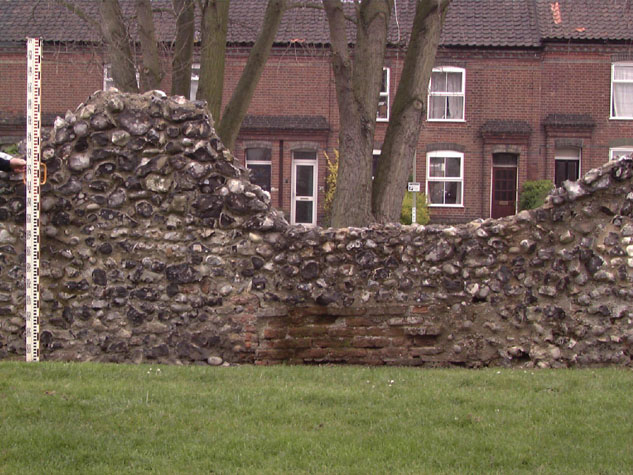
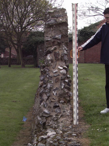
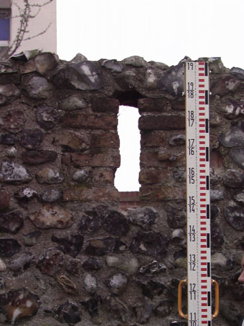
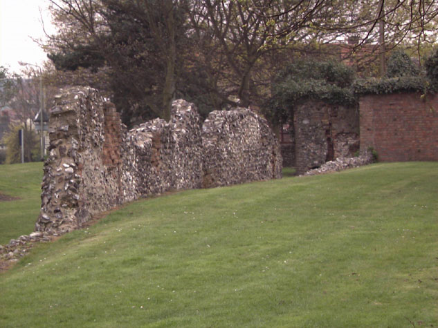
Historical Background ReportGeneral description of the historic fabricThe main part of the surviving wall has a very irregular wall top but the large area of flint above the surviving arches implies that it survives roughly to the level of the wall walk. On the inner south side little of the brickwork of the arches survives and much of the flint work is exposed core where the facing flints have been lost. [5] On the north side of the wall the face of the wall appears to survive in remarkably good condition. It would appear that there have never been buildings here to damage the wall face. [6] Horizontal lines across the mortar mark the different stages or lifts of the construction. These lines are about a metre apart and mark a single horizontal section of construction that was completed before the scaffold was moved up and the next level laid down. It has been suggested by Brian Morton that flint walls of this thickness with a lift of just a metre may not have needed shuttering. Face flint work on the inner and outer side with roughly knapped and coursed flints would have been set down carefully and then a looser core of flints and mortar built up. After the lowest stage was complete, scaffold timbers were laid across the wall top projecting on either side to carry planks or hurdles and the ends propped by poles. Generally, around the city walls bricks were laid on either side of the timber and across the top which kept the weight of the next stage of the wall off the pole. When the second stage had been laid, the timbers could be taken out and reused on the next level. At St Martin's Lane, curiously, there is no evidence for brick lined putlog holes for the scaffold. This may mean a different date for the wall or, more improbably, different masons. Certainly the stone loop in the eastern arch is a later feature but this could simply be an alteration or addition to the wall or may even, less probably, be a feature [1 & 7] that was reset from elsewhere, when the gate or one of the towers was demolished. [Survey drawing 10-05 Stone Loop] The loop in the second arch is a much more common form with a simple long rectangular opening though even here the details are unlike elsewhere on the walls. Here the external slit of the loop is simply formed in flint without brickwork though the internal splays of the embrasure are formed in brick. [8 & 9] Elsewhere the loops are formed with exposed brickwork. There is yet another anachronism. Here the surviving arches 2.2 metres wide have almost exactly the same dimension as arches elsewhere and yet are much more widely spaced. Elsewhere the pier between the arches is less than 2 metres here the space between the two arches is 4.7 metres and to the east of the first surviving arch there is at least 4.3 metres of blank wall. [Survey drawing 10-02 Plan] It is these major differences that make archaeological invest investigation in this area a priority. On the north side, the main section of the wall has been under built in brick indicating at least one major phase of repair. [Survey drawing 10-03 Ext Elev] If the wall here followed the form revealed in the excavations at Barn Road, then the flint wall was constructed on shallow footings on the front edge of an existing bank whose slope continued down into the ditch. The wall did not have a vertical outer face running down into a moat though in some parts where the ditch was deep or where towers projected into the ditch deeper footings were built. Here at St Martin's Lane there must have been a slope of soil against the base of the wall that in itself would have made it difficult to set up ladders to scale the wall. When the ditch was filled and the ground outside the wall was levelled this would have exposed the footings and it is logical to assume that it was at that stage that the wall was under built. The lower part of the wall to the west has been much refaced and little of the flint walling looks like medieval work. [10] The standing wall is narrow but the outer or north face of this wall is in line with the outer face of the main section to the east so if there was an arcade here then evidence may be found in any excavations on the south side of this wall. [11] The ground level on the side of the ditch is lower than on the south side of the wall and the profile of the ground south of the wall suggests that this is approximately at the medieval level. Again excavations might uncover any surviving levels from the lane inside the wall. At Barn Road this appears to have been loosely cobbled. On the inner or south face of the wall are large areas of brick blocking that are features surviving from buildings constructed against the wall. There is a blocked window and two vertical piers of brick work where walls running out from the flint wall have been stitched in. At the west end is a small loop that may, from its position and form, be essentially medieval but this could only be confirmed if the bay system of any arcade could be established through any excavation on the site. [12] The standing section of wall is set back about 14 metres from the south kerb of Bakers Road. How accurately does this reflect the width of the ditch? [13] The road is almost certainly wider than the medieval lane outside the ditch and as the line of the north side of the road was determined by well-established plot boundaries with individual owners the road may have encroached over the outer edge of the ditch. 16th-century documents suggest that water in the ditch from Oak Street eastwards drained not towards the river below Oak Street but east to the river at Pockthorpe. If the ditch here followed the form uncovered elsewhere, it was probably about 18 metres wide and as much as 6 or 7 metres deep. Documentary evidence:No medieval documents have been discovered in these searches that relate specifically to this section of the wall. The Customs book of the mid 14th century and the Roll of 1386 names the wardens who were responsible for this section of the defences. The Agistamentum of 1451 states that Colegate Ward was responsible for maintaining the defences from the tower at Oak Street described as 'the toure by the water' to 'Seynt Awstyn Gates'. Documents surviving from the 16th and 17th centuries suggest that not only was the ditch at Baker's Road filled with water but that it drained eastwards towards Pockthorpe Gate rather than the much shorter distance west to the river by Oak Lane. At an Assembly in 1553 (6th Edward VI)
In November 1622 it was ordered that
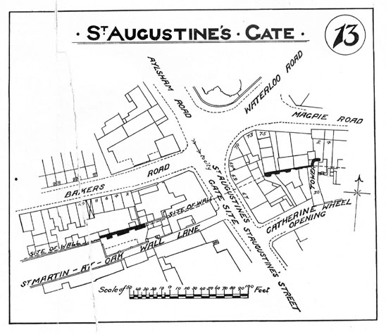
In 1861, Robert Fitch, in his introduction to the publication of the views of the gates, states that although there was then nothing remaining of St Augustine's Gate, a large portion of the ditch between this gate and St Martin's is clearly seen, very few buildings having been erected upon its site.' [Fitch xxxv] Map evidence:Kirkpatrick's map [Norwich Castle Museum 1894.76.1682: F] shows this section of the wall with a substantial rectangular block west of St Augustine's Gate and projecting out into the ditch. This is on the line of the brick and flint wall that is now immediately north of the electricity sub station. The map by Cleer of 1696 shows the walls partly in view and this 'tower' is shown as a substantial two-storey building. Hochstetter's map of 1789 shows the ditch with a fence on the outer side with what appear to be gardens within the ditch. There were no houses against the outer face of the wall apart from at each end where there were buildings against the outer sides of the gates. However, there do appear to be buildings against the inner or south side of the wall all along the inner lane between St Augustine's Gate and St Martin's Gate. [14] Houses were built along the line of the ditch in the mid and late 19th century facing on to Bakers Road. The map published with the report by A Collins of 1910 includes all the houses along the south side of Bakers Road, on the site of the outer ditch, that were demolished in the 1970s. [15] Historic views and historic photographs:There appear to be no historic views of this section of the wall. This is one section of the wall that was not photographed for the 1910 survey. Collins states that at that time parts of the wall were visible in the yards of the houses at numbers 2-10 Bakers Road but were hidden by building debris. Archaeological reports:No formal excavations have been undertaken in this area. CONDITION SURVEYList of known repairs:Not available at this stage. Presumably some work was undertaken when the houses on the Bakers Road side were demolished. Summary of present condition:The wall is generally in a good condition and no urgent repairs are required. Principal conservation problems:The general problems are shedding or loose flints, the intrusion of damaging self-seeded woody stemmed plants such as buddleia and the general problem of making the loose exposed core of the top and face as weather proof as possible.
|