City walls survey
13 Oak Street Tower
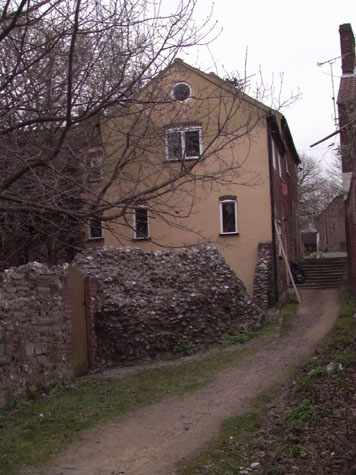
|
Conservation PlanThe present setting:The surviving base of the tower is on the west side of Oak Street and is reached by a narrow alley or lane with steep steps that drops down from the street between two houses. [survey drawing 13-04 Int Elev] The alley leads down to open ground and the river bank and runs directly across the south side of the tower. The alley broadens out beyond the end of the former Dun Cow and the site is actually very pleasant with old brick boundary walls, overhanging trees and well made and well tended steps with a timber and gravel construction. The tower can be seen easily from the lane and it is possible to climb into the tower from there. The north side of the tower is in the private garden of the house and there is no public access. It is difficult to see what could be done to improve the setting. With the lane on one side and the private garden on the other, the site is tightly constricted. Potential medium or long-term improvements recommended for the surroundings:Sign posts and information panels here would be inappropriate and might actually attract vandalism. The tower could be featured on any published guide to the walls and those particularly interested in the walls could find it...otherwise, increased visitor numbers are both unlikely and undesirable. Archaeological impact assessment:Archaeological investigation here is not a priority. Presumably the ditch on the north side was broad with few features though if any service trenches were dug in the garden of the house it would be interesting to establish any natural levels. On the north side of the tower and wall it would be important to establish if, as at River Lane, the foundations of the tower and wall continue down some way into the ditch. If the wall here followed the form of the wall at River Lane and at the Boom Towers running up to King Street, then there would have been no arcade for the wall walk on the city side. An excavation running north south on the west side of the tower might establish if the wall continued beyond the tower.CONSERVATION REPORT SUMMARY WITH RECOMMENDATIONS FOR ACTION
BIBLIOGRAPHY:Blyth, G.K., The Norwich Guide and Directory (London: R. Hastings; DOCUMENTARY REFERENCES:No specific references for this section. ARCHAEOLOGICAL REPORT:Department of National Heritage HSD9/2/1005 part 10 in Gressen Hall File 384 HISTORIC ILLUSTRATIONS:Ninham, Henry, NCM 1929.89.39:INT, 'Interior of one of the Towers on the |