City walls survey
13 Oak Street Tower
|
|
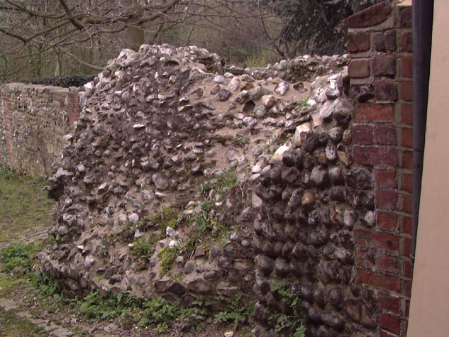
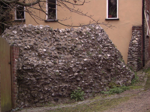
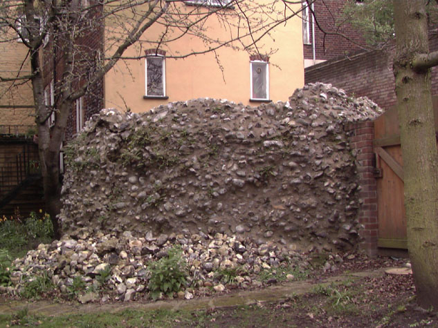
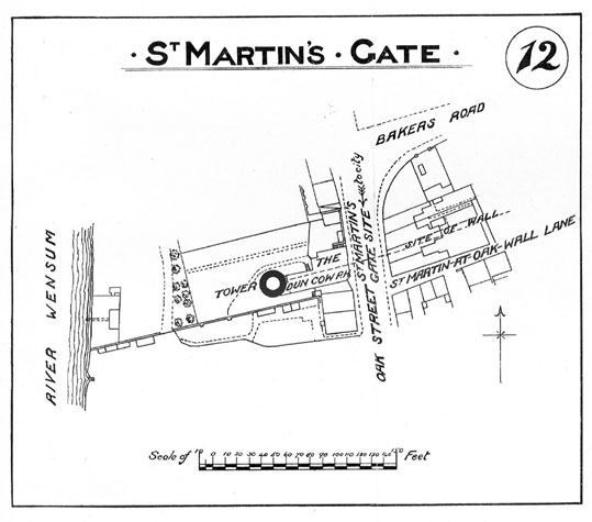
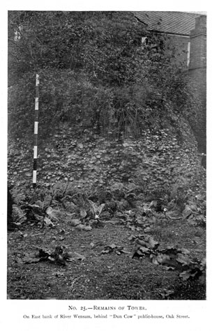
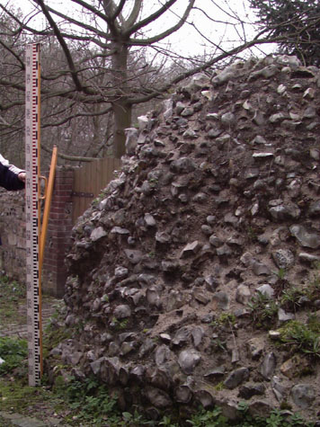
Historical Background ReportSummaryThe tower is of considerable historic interest. With the lost tower on the river bank east of Heigham Gate it closed the northern defences of the city and is comparable in form and in function to the riverside tower near Pockthorpe Gate and the two Boom Towers on the south side of the city. From the present mound of flint work here now it is difficult to imagine the substantial tower that stood on this site. [Photographs 3 & 4 and survey drawing 13-03 Ext Elev] It had the same diameter as the east Boom Tower and may have been almost as tall ... possibly 8 metres high. The tower would have been relatively tall in order to have as level a top to the wall between the gate and the river as possible. General description of the historic fabricThe surviving flint forms a circular mound with the top of the wall being rounded. No face flints survive on the south or inner side and the north side towards the garden looks much rebuilt. [5] There is no indication of a plinth or thickening of the wall at the ground. The centre of the tower is hollow and has an internal ledge just above the ground though this is much damaged and irregular. [survey drawing 13-05 East Sec] It may represent the level of the floor of the lower chamber. A set back on the north-east side may represent the splayed jambs of a loop that would have looked back along the outer face of the wall towards St Martin's Gate on Oak Street. There is no evidence for a doorway into the lower chamber from outside on the inner or south side. This is difficult to reconcile with the descriptions of the tower in the 19th century as having vaulting. If it was the lower chamber that was vaulted how was it entered or has the base been so extensively rebuilt that the evidence for a doorway has been lost? If the tower had an upper chamber and that was vaulted, a lower chamber could have been entered by way of a ladder dropped down from above through a hatch in the floor. The wall in the basement of the former Dun Cow is 3.2 metres long and forms an internal wall of the cellar. It is on the line of the defensive wall though it is not proven to be medieval. The flint is painted and there are no features within the wall. Documentary evidence:The Oak Street Tower is mentioned by Blyth in 1842 as being on the west side of the St. Martin's Gate site, on the end of a small wall, 'the remains of a tower, which is going fast to ruin.' He notes that as 'The rivulet [is] at some distance west from the tower, it has been conjectured that this channel is altered, as this wall was undoubtedly designed to meet the stream.' Considering the wall from this place back to St. Augustine's Gate, Blyth comments that there 'are several towers, now converted into habitations, and the wall is chiefly built upon.'[Blyth, pages 4 and 5] This is the tower that Fitch mentions as surviving next to the river in 1858. [Fitch, page 24] There is a letter from the Department of National Heritage (HSD9/2/1005pt10) contained in Gressen Hall file 384, concerning proposed works at the Dun Cow, House on the Wall, at 167 Oak Street. It refers to the construction of a new extension to the existing building along the road frontage. Map evidence:Cunningham's map of 1558 shows not only the tower west of St Martin's Gate but also a length of wall beyond the tower running down to the river bank. There is no surviving evidence to suggest that this wall existed and it is still probable that the tower was actually on the river bank. That is the arrangement drawn by Cleer on his map published in 1696. Neither Hoyle in 1728 nor Blomefield in 1746 show the tower though both show the way the river split here with a narrower stream to the west and a bleaching ground on the island between the stream and the main channel. The maps suggest that drainage in this area had been altered. The assumption must be that in the 13th century this ground was very wet and marshy providing a form of natural defence. Water and wet land probably came right up to the tower. If the river was channelled at all it was further down stream, closer to the site of the mill and where the defensive wall resumed close to the east side of Heigham gate where there was another circular tower. The Oak Street tower is shown on the Hogenberg and Braun's version of King's map in the 1760s though there it is set back from the river bank. Hochstetter's map of 1789 is important as it depicts not only the surviving wall and tower but also the gate at St Martins shortly before it was demolished. This shows the relationship of the wall and gate. Unlike many of the gates, St Martin's Gate was set back with the outer face of the gate flush with the outer face of the wall. The map is too late to show the arrangement of the fore works of the gate and the ditch here which by that date had been filled in with gardens on the site east of the gate. There were houses outside the gate along the top of the bank on the west side of the road. The lane inside the walls to the south of the tower is shown but at that stage it ran down to a narrow stream with the main channel of the river further to the west. The map published with the report of 1910 shows the wall and tower much as it is now. The house east of the tower, facing onto Oak Street is labelled as the Dun Cow Public House. [6 & 7] Historic views and historic photographs:On his pencil drawing of the tower dated 1850 Henry Ninham wrote that,
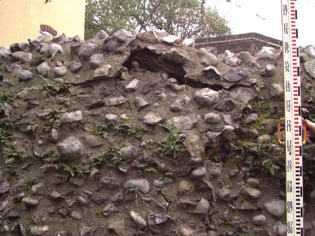
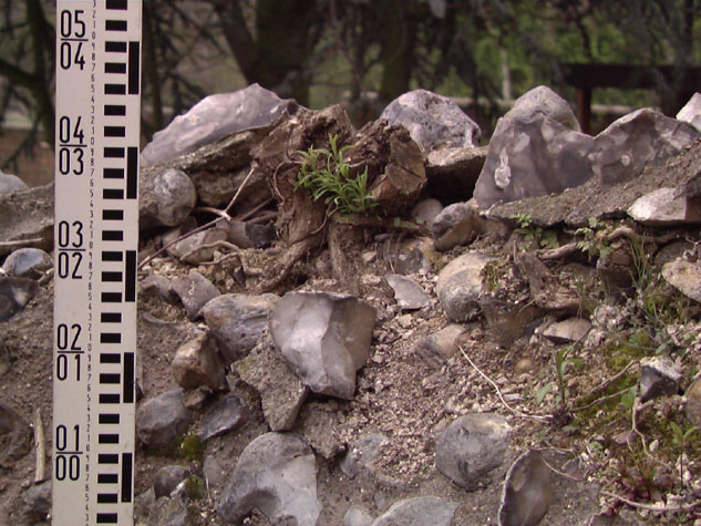
The drawing itself shows vaulting and three arches, all in brick. The ceiling is ruined just above the vaulting. By then, the tower was in an advanced state of decay with daylight coming in and grass growing around the top. [NCM 1929.89.39:INT, 'Interior of one of the Towers on the City Walls, St. Martin's at Oak Gates, 1850'] Archaeological reports:There are no reports on file for any archaeological investigations of the tower or the wall here. CONDITION SURVEYList of known repairs:Not available at this stage. Summary of present condition:Generally the base of the tower is in a poor state of repair and susceptible to further damage. A large area of fallen flints has accumulated against the base on the garden side and several root stocks of self seeded buddleia on the top of the wall have caused deep fissures to open through the flint work. [8 & 9] Once water enters these cracks there will be more damage and more loss of flints. Consolidation of the remaining part is needed urgently. Principal conservation problems:The main problem is damage from water entering the exposed core ... there is virtually no face flint surviving. There is presumably also some damage from vandalism as children climb or play on the wall.
|