City walls survey
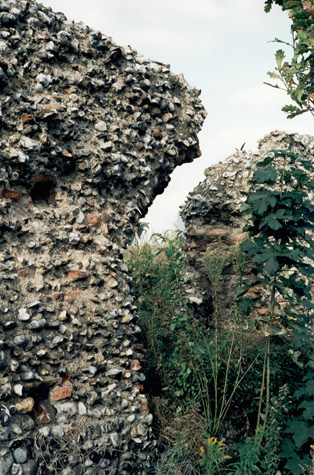
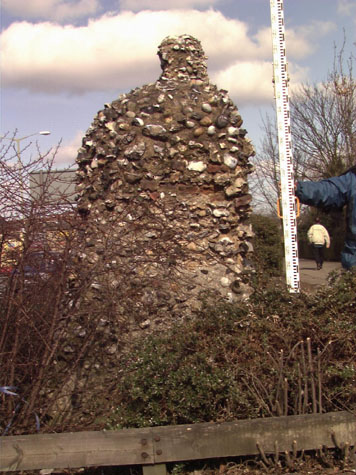
16 Barn Wall Road
|
|
IntroductionThis section of the surviving wall is at the north-west side of the city, south of the site of Heigham Gate and immediately north of the site of St Benedict's Gate. The standing section is 57 metres long with the remains of six arches of the wall-walk arcade and, after a breach where three arches have been lost, there is a seventh arch standing in isolation at the north end. The surviving section was 19 metres north of the gate at St Benedict's and there would have been a further three arches between the gate and this part. The wall is in a very poor state with mostly core work exposed. [1] Several of the arches are cracked and broken and water penetration and frost damage are throwing out flints and any surviving bricks. The standing part is at most 3.4 metres high and at no point does the wall survive up to the level of the wall walk. [2] Two of the arches have been broken through at the top and the corbelled-out stubs of flint and brick are vulnerable to further collapse. In part, the present condition of the wall was caused by work undertaken in the 19th century when houses were built hard against the wall on both sides. It would appear that the arches were filled in with flint masonry and the outer part of the wall was removed which suggests that the outer part was crumbling and in poor repair but the inner arcade was relatively strong. The flint work was further damaged by the impact of bombing during the Blitz in 1942 and areas of flint were lost when the remaining parts of the houses were demolished. The devastation caused by the bombing can be seen in a photograph in the Norwich Studies Library taken from Duck Lane and looking across the site of St Benedict's Gate. On the west or outer side of the wall are the remains of an intermediate tower that stood 40 metres from the north side of St Benedict's Gate. Only footings of the tower survive and these have been altered. This tower was semicircular in plan but the outer face was squared off when the dual carriageway on the line of the outer ditch was constructed in the 1970s. The tower was 7 metres across at the widest part. Despite its poor state, this section of the wall is very important because it is the only part of the defences where extensive and systematic archaeological excavations were undertaken over a relatively large area. The site of the tower and wall were excavated in 1947 and further work in 1951 and 1953 was completed here and on the wall and ditch south of St Benedict's Gate. The general conclusion from those investigations was that the flint wall had been built on a shallow foundation trench cut on the top of an existing bank. The full width of the ditch was excavated across the line of what is now Barn Road and the inner side of the wall was excavated to reveal the level of the lane inside the wall that here was cobbled. The present ground level is about 800mm above the medieval level. |