City walls survey
16 Barn Road Wall
|
|
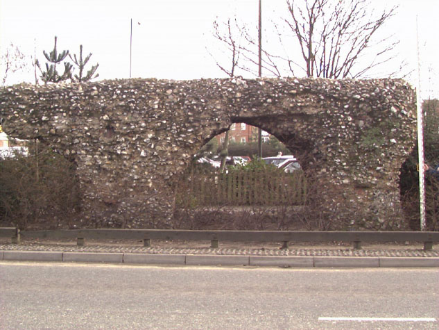
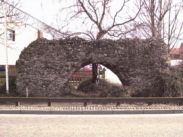
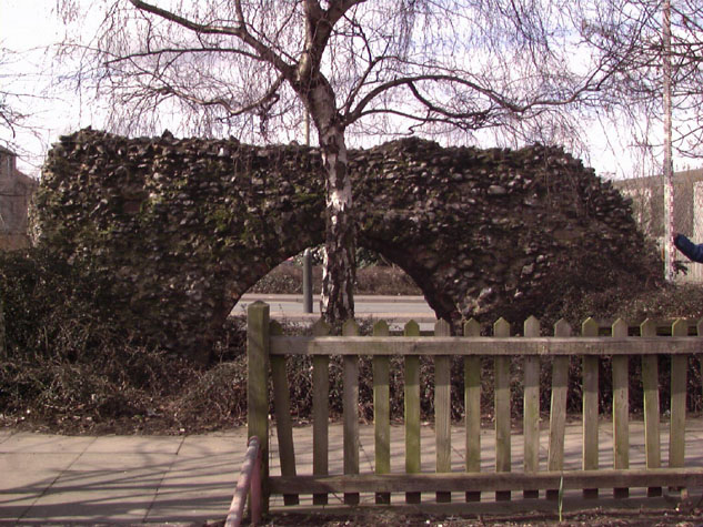
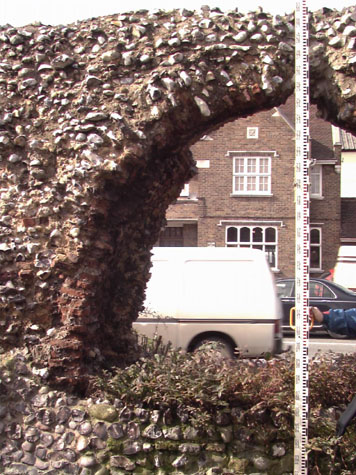
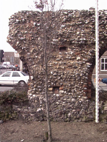
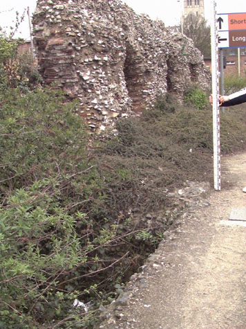
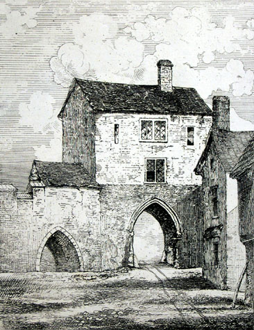
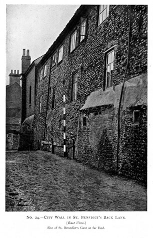
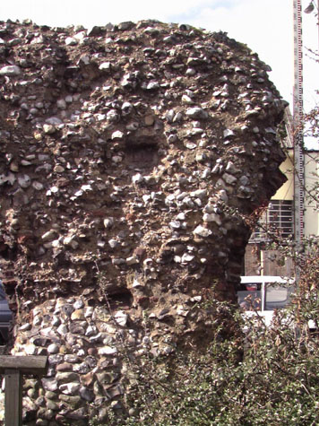
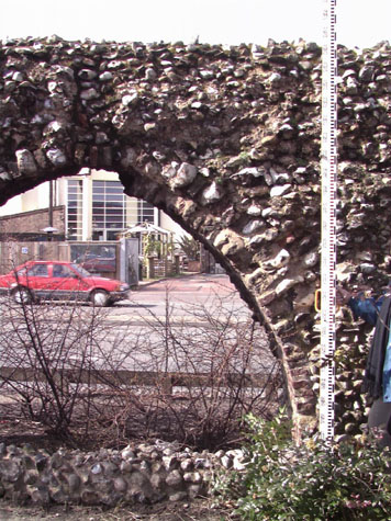
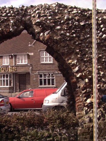
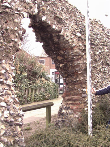
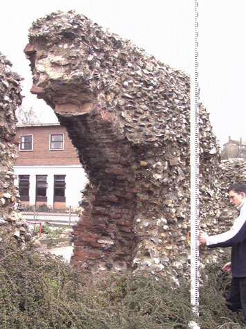
Historical Background ReportGeneral description of the historic fabricThis section of the surviving wall is at the north-west side of the city, south of the site of Heigham Gate and immediately north of the site of St Benedict's Gate. The standing section is 57 metres long with the remains of six arches of the wall-walk arcade and, after a breach where three arches have been lost, there is a seventh arch standing in isolation at the north end. The surviving section was 19 metres north of the gate at St Benedict's and there would have been a further three arches between the gate and this part. [3, 4 & 5] This section of the wall was constructed in the late 13th or early 14th century on the top of the bank of an earlier defence. The wall was built on the front edge of the bank and stands on shallow foundations of layers of flint and mortar in a shallow trench cut into the top of the bank. The wall appears to have had an inner arcade from the start, the arches supporting a wall walk with an outer crenellated parapet. Although the surviving arches are badly decayed sufficient remains to show that the wall was constructed in much the same way as the more substantial sections surviving at Carrow Hill. The decay of the flintwork is so great that it is difficult to take precise measurements but the arches appear to be about 2.6 metres wide, slightly wider than at Carrow Hill. They were regularly spaced about 2.1 metres apart, again slightly wider than at Carrow Hill. This may explain why there appear to be fewer battlements in this section, given the distance, than in other parts of the walls. The arches were about 1.8 metres high from the ground to the springing and 2.4 metres high overall to the apex. The arches were formed with two rows of headers. [6] In the centre of the piers are the remains of putlog holes lined with bricks at two heights implying that the main part of the wall was constructed in three stages or lifts. [7 & 8] The putlog holes run at the same level all along the main part of the surviving section. There is a slight change of level in the detached arch at the north end which probably reflects the fact the wall stepped down at several points as the wall dropped down the slope towards Heigham Gate and the river. On the outer side of the wall was a very broad and deep ditch whose dimensions must reflect the amount of water that drained down the ditch down Grapes Hill to the south. [16-01 Map] Excavations here by E M Jope in 1948 established that the ditch here was over 18 metres wide and about 5.2 metres deep with a flat bottom. The water table was 4.5 metres below the surface so the ditch must always have been filled with standing water however much or however little drained down the hill. More significant perhaps is that the level of the river is only about 4 metres below the present ground level. Archaeological finds suggested that the ditch had been kept relatively clear until 1500. It had then slowly silted up and systematic filling-in began about 1700. Archaeological excavations of the wall in 1951 and 1953 were published in 1957 by Hurst and Golson. The drawings of the site show that at that stage the bases of six complete arches were uncovered north of the tower and after a gap (where there had been two more arches) the north jamb of the ninth arch was excavated. South of the tower the dig uncovered the bases of six arches where there are now only four and the north side of the fifth. Jope also excavated the surviving base of a tower on the outer side of the wall. [16-02 Plan] This was semicircular to the ditch and was described as three-quarter circular inside. [9] Kirkpatrick in the 18th century seems to have adopted the term horse shoe-shaped for this form of tower. The tower was 7 metres across with external walls just under 2 metres thick. The internal wall was much thinner, only 540mm, and Jope considered this to be integral and original to the tower. The excavation plans show arches on either side of the tower and overlapping or cutting across the line of the outer wall of the tower. This is a very strange arrangement which would seem to weaken the tower and is certainly not found anywhere else on the defences in Norwich. Jope's plans must be correct as part of the south arch survives. The arrangement might imply that the tower was added but the irregular spacing of the arches here suggests that the tower was an integral part of the primary construction. The threshold of a doorway into the tower was uncovered with steps in red medieval bricks and part of a jamb in oolitic limestone. [Jope 1948, plates 111a and b] The front face of the tower had a chamfered off set and the footings continued down some 3 metres below the present ground level. This must reflect the fact that masons were building the flint walls out into an existing and water filled ditch. There were 3 putlog holes lined with bricks immediately above the chamfered offset. The tower had a medieval mortar floor 1.5 metres below existing ground level. On the inner side of the wall was a roadway - the lane inside the wall - that had a pebbly surface. [Jope, 1952 page 296] In 1953 when an inspector from the Ministry of Works wrote a report on the walls, there were still some face flints on the tower and the interior of the tower was lime washed. The surviving arches follow the descent of the slope down to the river although the modern road has levelled out the gradient. [16-03 Ext Elev, 16-04 Int Elev, 16-05 Reconstruc] Presumably the wall walk and the parapet also stepped down along the length of the wall between St Benedict's and Heigham Gate. Documentary evidence:According to Blomefield's transcription of the last leaf of the Book of Customs, from Heigham Gate to St. Benedict's Gate (incorporating both sections of Barn Road) there were 79 battlements along the walls. [Blomefield, page 98] As the distance between the gates was about 235 metres, and as elsewhere the merlons were about 2 metres wide, there would seem to be too few battlements. Either the assessment is wrong or part of the wall may not have had a crenellated parapet. Blyth notes that this stretch of wall 'from St. Benedict's to Heigham gate is built upon within and without.' [Blyth, page 4] [10] Map evidence:Of all the early maps, Kirkpatrick's map [Norwich Castle Museum 1894.76.1682: F] is the only one that depicts this section of the wall accurately, showing two towers between Heigham Gate and St Benedict's. However, the 18th-century maps by Hoyle, Blomefield and King do show that there were few buildings in this part of the city, presumably because it was low lying and damp. There were no buildings outside the walls between the gates and inside the walls there was a large area of open land between Nether Westwick and Upper Westwick, later called St Benedict's Street. Archaeological evidence suggests that the ditch along this section of the defences was filled in about 1750 and after that change and development was rapid. By 1789, when Hochstetter surveyed the city for his map, much of the land was still open but he shows houses encroaching on the ditch. Buildings in the centre between the gates, just north of this section, appear to straddle the wall and imply that by then at least part of the wall had been removed. In the 19th century large numbers of small, tightly-packed houses were built, in part associated with industrial development. Inside the walls, just south of Heigham Gate a Crape factory was built and there were gas works and iron works built outside the ditch to the north west. By 1885, the date of the first edition of the Ordnance Survey map, [sheet LXIII.11.17] there were houses built over the ditch, hard against this surviving section of wall, with gardens and frontages to Barn Road. The lane inside the wall, then called St Benedict's Lane, was free of encroachment, though beyond this section to the north the wall had been demolished and the lane was blocked with buildings. The same buildings are shown on a sketch map published with the report of 1910 and these presumably survived until 1942 when much of the area was damaged by extensive bombing. [10] Historic views and historic photographs:A view of Heigham Gate by James Reeves shows an arch to the south of the gate which, with the surviving arches in this section close to St Benedict's Gate, would suggest that the whole wall between the gates had an arcade on the inner side to support the wall walk. [Norwich Castle Museum 1894.76 FAW 306 :INT][11] A photograph of the houses built against the walls taken before 1910 was published in Collins Report. [Collins 1910 plate 24] [12] This is looking down the inner side of the wall from the north towards St Benedict's Gate. The remains of the gate can be seen clearly at the far end of the alley. The houses built on the outer side of the wall, over the site of the ditch, were of three storeys. The ground floor wall has shadows and patching indicating the position of arches. Above a rough irregular offset, in part rendered, the upper floors of the houses also appear to be built in flint. Was this material robbed out of the walls when the houses were built? A surveyors staff in the photograph shows that the medieval part of the wall was then about 9 feet high from the level of the lane. Archaeological reports:
CONDITION SURVEYList of known repairs:Not available at this stage. Summary of present condition:The general condition of the wall is poor mainly because so few face flint survive and the exposed core has such an irregular surface that water is held back and penetrates into the wall around the flints rather than running off. [13] The problems were clearly identified in a report by the Ministry of Works in 1953. That report is worth quoting in full here as the situation has not been remedied in the intervening 50 years. "Barn Road with Base of one TowerAs a result of enemy action and some subsequent archaeological excavation portions of the wall are now exposed on both sides, and quite a lot is known about their construction and date. The present surface of the ground at this point is much above the 14th Century level, and it is known that the wall face exists at a lower level, whereas the standing remains are mostly of corework. If this accumulation of earth were removed, it would be found that these remains are really higher and more impressive than they now seem to be, with good facework at the base. They would also be found to be linked together, whereas now they are in two parts. It is most desirable that this earth be removed and a scheme be prepared for a small open space enclosing the remains of the wall and the base of the tower, which has excellent masonry. With this done, as well as the City Wall on the other side of St Benedict's Gate adequately preserved, in the manner advocated in the foregoing section, there would be a second most impressive entry into the medieval city, complementary to that astride King Street. Before the removal of any earth from the base of the wall, the existing arches and other remains must be carefully consolidated and those arches which have fractured should have small reinforced concrete beams inserted in the corework above the arch stones, or the level where they have been. All concrete work must, of course, be covered by core or facework as the case may be. Again, the ends of each section must be left rough but sound. The very high quality facing flints in the base of the Tower are now falling away rapidly and already the deterioration since exposure has been considerable. All loose flints must be re-set in complete character with the undisturbed facing and the wall-tops waterproofed by the addition of a small amount of cement to the lime mortar. In the debris now in or just outside the tower should be found an original door jamb stone and step which was in situ at the time of excavation. If found, this should be re-set in its original position. After excavation of the earth, the newly exposed wall facing should be treated as necessary. Urgent: �120 Principal conservation problems:
|