City walls survey
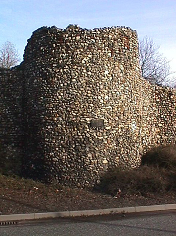
22 Chapelfield Park (Tower and Wall)
|
|
IntroductionAt Chapel Field the surviving section of wall stands on the west side of the Gardens and forms the boundary between the park and the dual carriageway of the inner ring road that is built over the line of the outer ditch. The ground here is relatively level and the standing wall runs from north west to south east with a slight outward curve. It was part of the defences between St Giles' Gate and St Stephens' Gate. From St Giles' to the site of the gateway at St Stephens is about 655 metres ... the single longest stretch of the wall on the circuit of the defences. There were 6 intermediate towers between the gates and the 14th-century Custom Roll indicates that there were 229 battlements on this section. The surviving section of the wall at Chapel Field is 137 metres long and at its north end incorporates a substantial part of the 3rd intermediate tower. The wall is 4.75 metres at the highest point but all of the parapet (probably about 2 metres high) and, in some sections, much of the upper part of the wall itself has been lost. The tower too has lost its crenellated parapet but still stands slightly higher than the wall at 5.6 metres. [1] A number of loops in brick and many of the brick-lined putlog holes from the original scaffolding survive. The wall has a number of arches or narrow gates through it but these all date from the 19th century when houses were built hard against the outer face of the wall, over the line of the ditch. These houses had private access to the park by way of these gateways cut through the wall. The demolition of these house in the 1970s damaged much of the outer face of the wall but there is evidence to suggest that the wall is approximately the same width as the medieval wall. Certainly, there is no evidence for there having been an internal arcade on this section to support a wider wall walk. Some of the construction details of the wall, for instance the way that the side bricks of the putlogs are laid flat rather than vertically, are different from other sections. Documentary evidence suggests that this could be one of the first sections of the flint wall to be built and it may date from about 1253. It is now known that parts of the Saxon and Norman settlement of Norwich had been protected by a ditch and bank and many of the principle streets were laid out then. However, although the site if not the structure of many of the gates may have dated from the 12th century, the city was not enclosed by a continuous defensive system. It was not until 1253 that the citizens of Norwich were granted a licence by Henry III to enclose the city and even then, it is generally believed that the flint-built wall was not begun until the raising of the first murage tax in 1294. [Fitch page v and page viii] However, a document refers specifically to a wall, rather than a ditch, in Chapel Field about 1256 (16th Edward I) which may suggest that by then a palisade on the bank may have been replaced with a flint wall. |