City walls survey
22 Chapelfield Park (Tower and Wall)
|
|
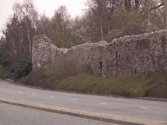
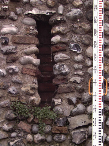
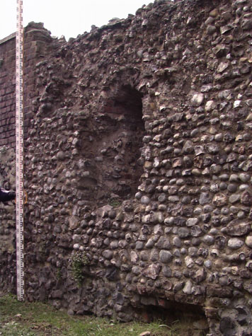
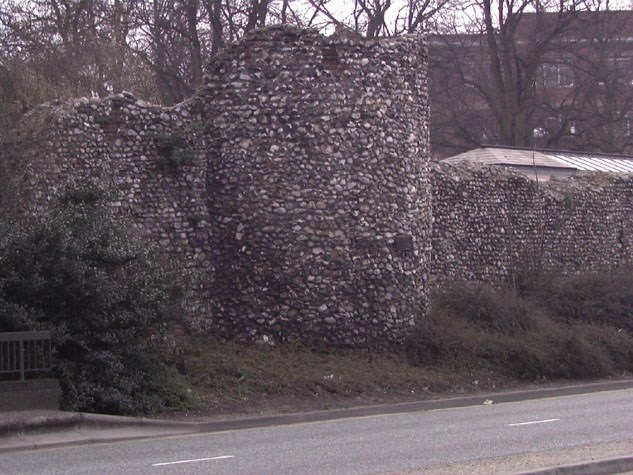
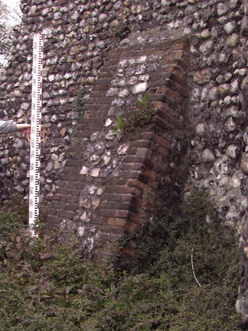
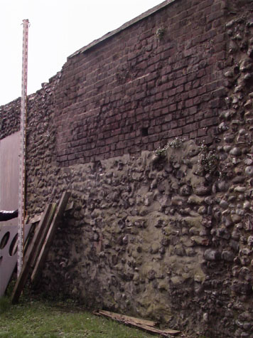
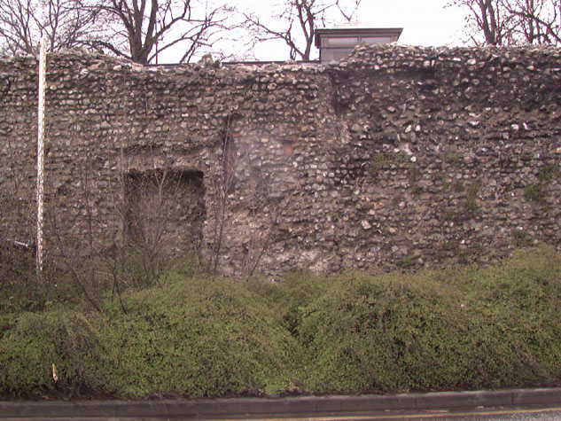
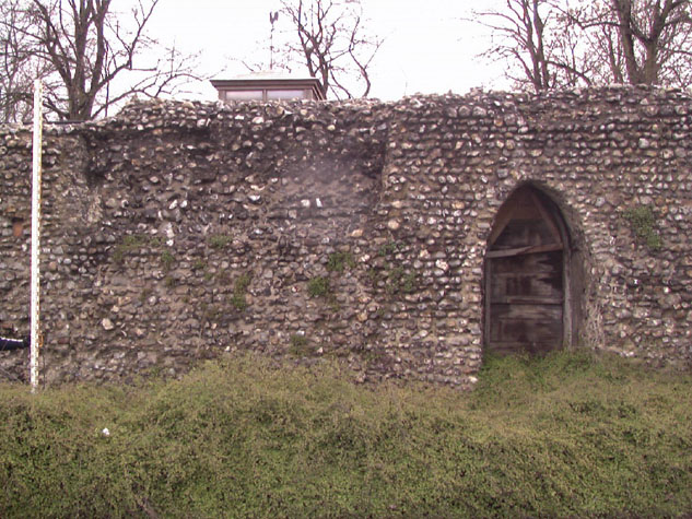
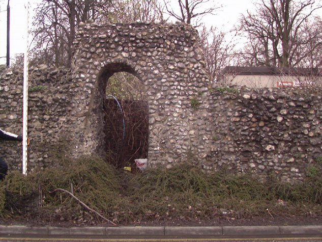
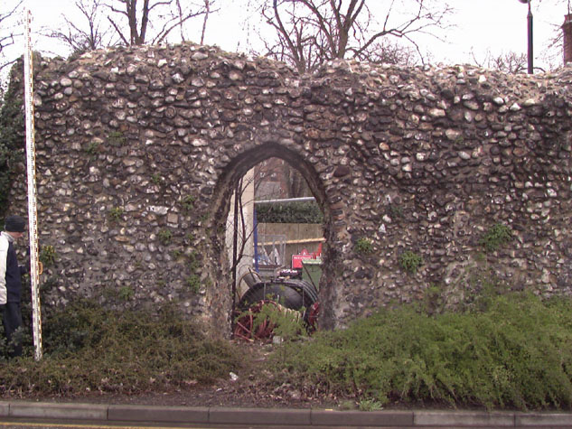
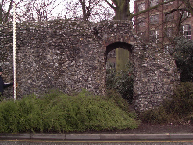
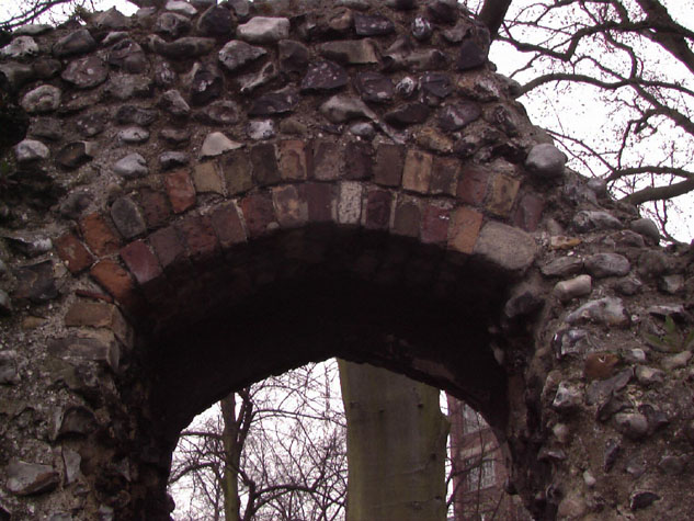
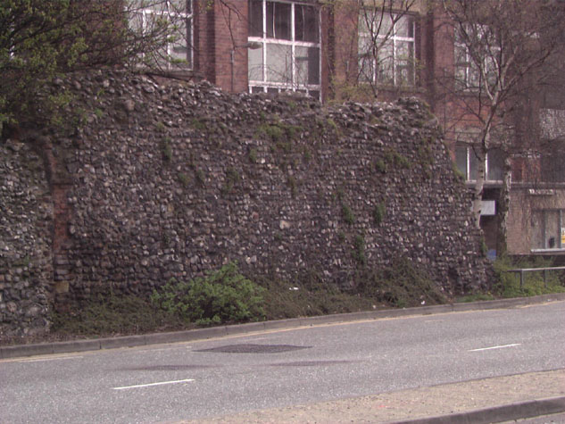
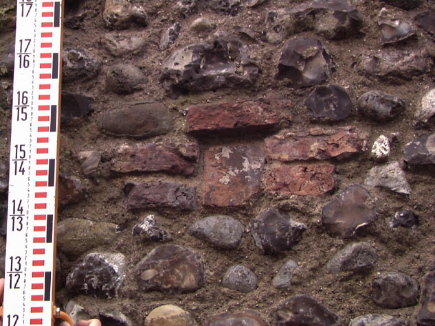
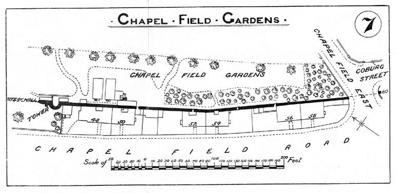
Historical Background ReportGeneral description of the historic fabricThe surviving wall is on the west boundary of Chapel Field Gardens and runs from the remains of a tower at the centre of the west side to the south-west corner of the park. [22-01 Map] The standing section is 137 metres long and is on relatively level ground on a line running from the north west to the south east. The wall bows outwards slightly towards the centre towards the line of the ditch that was on the south-west side of the wall. [22-02 Plan] The surviving part is approximately 4 metres high but it has lost all of its outer parapet that would have added almost 2 metres to the height and in many parts much of the upper part of the wall has also been lost. [2]The position of surviving loops suggests that the present level of the ground inside the wall is close to its medieval level. The wall is now on average 1.2 metres thick but at several points is as much as 1.8 metres thick. Map evidence suggests that there have never been substantial buildings against the inner side of the wall and in many places the inner face of the wall is essentially intact though repaired and re-pointed. [22-04 Int Elev]This is exceptionally important here ... elsewhere, on other sections of the wall, the inner wall face was badly damaged and much evidence lost when 18th and 19th-century buildings against the walls were demolished. At Chapel Field there are no actual remains of an internal arcade to support a wall walk and there is no evidence on the internal face of the wall, in the form of brick ends or the shadow of arches, to suggest that an arcade has been removed. The conclusion at this stage must be that there was not an arcade here but the explanation for this difference has to be conjectural. Either the wall was one of the first sections to be built, before the form of the arcade supporting a wall walk had evolved, or, less likely, the position of the wall meant that strategically the wall here did not merit an arcade and wider wall walk. On the outer side of the wall are the remains now of five brick lined loops [22-03 Ext Elev] but on the inner side, where the wall face is less disturbed, there are eight regularly spaced loops. A ninth loop can be inferred, from the regular spacing of the loops, to have been lost where a gateway was cut through in the 19th century. The apex of the arch of the loop embrasure is not level but slopes down slightly from the apex of the arch on the inner wall face to the top of the loop on the inner line of the embrasure. [3 & 4] These loops are just over 6 metres apart. This, in itself is also significant, for where the arcade was an integral part of the construction of the wall, the loops, central to each arch, are only about 4 metres apart. One specific problem for an interpretation of the evidence here, is the lack of evidence for the width and the form of the wall walk. If the wall was as much as 1.8 metres wide then it had much the same overall thickness as those sections that were built with an inner arcade. At the Black Tower the outer parapet is only about 450mm wide. There is also an inner parapet at the steps up to the tower but further along the wall the inner edge of the wall walk has broken away and evidence for the existence of an inner parapet has been lost. Would an inner parapet have been needed on the main sections of the wall? It depends in part on how the wall walk was meant to function. Was it an intermediate platform where fighting troops, specifically archers, could take up positions to defend the city or was it primarily a route between towers for guards patrolling? If the wall at Chapel Field had an inner and an outer parapet of about 500mm then the space left for the wall walk would have been about 800mm (or 2'6") wide providing little space to manoeuvre. The only section of wall where an inner lip of flint implies that there was an inner parapet is at Magdalen Street and much of that evidence is close to the site of the gate where any inner parapet may have been constructed to protect the steps up into the gate. The tower at the north end of this section was the third intermediate tower south of the gate at St Giles.[5] It is semicircular in plan, 5.3 metres across and projects into the ditch by about 2 metres. [22-05 North Sec] This is one of the smaller towers ... intermediate towers elsewhere are generally between 6 and 7 metres in diameter. The tower has lost much of its upper part but still stands to a height of 6 metres rising higher than the flanking walls. The outer face has one area of patching on the south side that might cover the position of a loop. On the upper level there is evidence for two loops on the outside where brick work survives on the south and south west sides and on the north side on the inner face there is a large area of blocking in brick which may indicate a third loop. On the inner side of the tower at the ground level all the medieval fabric and any evidence of the plan and form of the tower is covered by the modern toilet block set within the tower. If the tower was like other towers on the circuit then there would have been loops set to provide sight lines from inside the tower out along the outer faces of the flanking walls. What evidence there is at the upper level would suggest that the tower was open on the inner side. The survival in part of a rough inset in the wall of the tower just above the roof of the toilet is probably where the wall walk continued round into the tower. If, and less likely, the tower was closed on the inner side, then the off set could have supported the timbers of a roof or platform at that level. The wall continues for just over 4 metres north of the tower before now tapering out. There is a raking buttress in this section on the outer face of the wall with brick corners which is presumably part of a 19th-century repair. [6 & 7] The flanking walls of the tower do not simply butt up to each side. On both the north side and the south side the wall is angled outwards slightly a metre or so before the tower. It is difficult to see now if this is a significant medieval feature, that might suggest the tower pre dated or post dated the wall or it may simply reflect awkward repairs or re-facing. On the inner side of the wall, behind the nursery school, part of the bank against the wall survives. [8] To the south of the gateway at the boundary between the school and the depot, the bank has been in part removed and has exposed the looser flint and mortar walling of the footings. The wall to the south of the tower has 5 narrow gateways cut through it. [9, 10, 11, 12, 13 & 14] These date from the 19th century and were constructed to provide private access into the Gardens from the yards of the houses built against the outer face of the wall when the ditch was filled in. At the south end of the wall there are more extensive areas of repair and rebuilding with sections of brickwork. [15 & 16] There is one loop surviving on the inner face just over 4 metres from the south end. The evidence for the spacing of the loops here is less certain but again there is a general pattern of loops every 6 metres. One area of brick under building looks a little as if this covered a drain running out to the ditch. Along the outer face of the wall is a single level of putlogs suggesting that the wall here was raised in two lifts to the level of the wall walk. Elsewhere there are two levels of putlog holes implying three lifts. The putlog holes at Chapel Field are not logically spaced and do not relate specifically to the spacing of the loops although the putlogs are set at about the level of the top of the loops which meant that scaffolding timbers could have been set up through the loop. The bricks on the sides of the putlog holes are set flat and laid running out from the putlog with two courses and with single bricks laid across the top, laid parallel to the line of the wall. [17] Elsewhere the side bricks of the putlogs are generally laid with vertically set bricks. Documentary evidenceIn a Leet Roll from the 16th year of the reign of Edward I (1255/1256) the millers of the Prior of Buckenham had undermined the ditch between St Giles Gate and St Stephen's Gate and 'made a purpressure under the walls.' The Prior's mill was in 'Chapply Field' and purpressure generally refers to illegal enclosure or fencing in of land. [Fitch page 12] The document specifically refers to walls ... in other 13th century documents other sections of the defences are described as the ditch. Furthermore, in 1266 or 1267 John the Carpenter sold all 'his said messuage lying near the Gate of Needham', (St Stephen's Gate) to the Citizens and Commonality of Norwich, 'for their more convenient building of the wall of the city there.' [Dom.Civ. quoted by Fitch page 12] Blomefield cites the last leaf of the Book of Customs, which notes that along this stretch of wall between St. Giles and St. Stephen's gates were 229 battlements on the walls and towers.[Blomefield, page 98] Chapel Field takes its name from the chapel of St. Mary which used to stand in the grounds. Blomefield notes that in 1402 this chapel was a meeting place for assemblies. [Blomefield, page 119] In 1406 the citizens of Norwich 'claimed four acres and an half of ground which belonged to Chapel in the Field ... lying in Chapel-field Croft, within the city ditch, on which it abutted south ...' [Blomefield, page 124] In 1549, at the time of Kett's Rebellion, soldiers made several breaches in the walls, betweeen St Stephen's and St Giless Gates 'which were broken open at my Lord of Warwicks comyng.' [Comp. Camerar cited by Blomefield, page 248] In the 17th century Sir John Hobart of Blickling seems to have used Chapelfield House as a town residence. This was on a large plot of land now within the Nestle factory site. He took a 40 year lease on the open land later to become Chapel Field Gardens with...
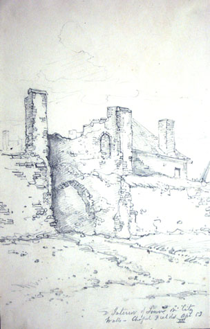
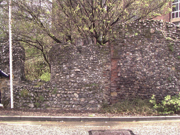
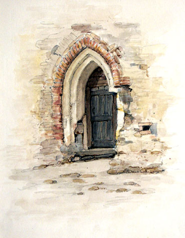
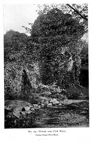
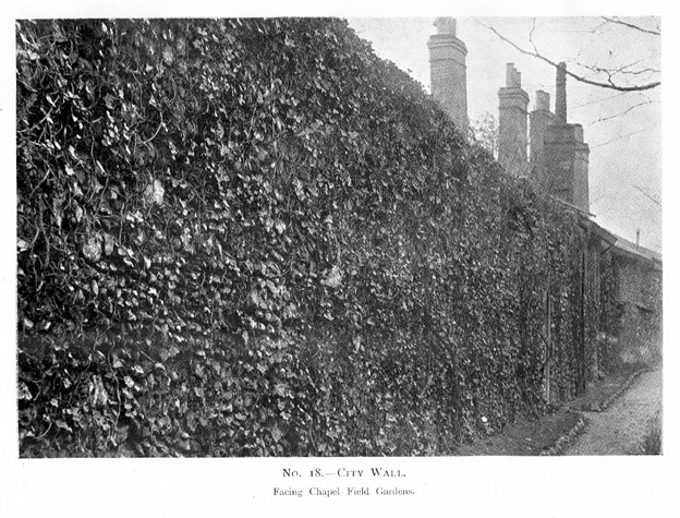
The Norfolk Annals for 1852, compiled from articles in the Norfolk Chronicle, reports, on the 17th of April, the opening of the pleasure gardens by the Corporation [Annals, vol. I, page 11], while an entry for 1867 explains that after being closed for some months, the gardens were re-opened, with 'several portions of the city wall ... removed, and railings erected, and efforts ... made to level the area.' [Annals, vol. II, page169] Map evidence:Cunningham's map of 1558 is actually a view of the city from the west. The Gate of St Giles is almost central to the view and Cunningham shows clearly the triangle of open ground that is now Chapel Field Gardens. The space has cattle grazing and human figures that appear to be archers practising. There are only five towers shown between the gates for Cunningham omits the sixth tower immediately before St Stephen's Gate. In the late 17th century and throughout the 18th century all the cartographers have problems deciding which of the six towers were still standing. Kirkpatrick, generally very accurate, shows only five towers about 1714 but appears to have omitted the tower at the south end of this section at the end of the street that is now called Chapel Field East. Cleer in 1696 shows four towers ... the now lost tower north of this section, the surviving tower in this section, the lost tower at the end of Chapel Field East at the end of this section and the polygonal tower on Coburg Street. He omits both the first tower after St Giles, the Drill Hall tower that actually stood until 1970, and the sixth tower by St Stephen's that is still standing. Hoyle in 1728 and Blomefield in 1746 missed out the same towers. Hogenberg and Braun in their version of King's map of 1766 show all six towers standing and all are shown in approximately the right position although the surviving tower in this section is shown slightly too far to the south, too close to the corner of the gardens. Perhaps the single most important thing shown by the maps is that this section of the wall has always been clear of buildings on the city side. Elsewhere in the city, damage and deterioration of the face of the flint work has been caused primarily by the demolition of houses that had been built against the walls in the 18th or 19th century. Here there is little reason to doubt that the wall face on the inner side is, ostensibly, the medieval wall face be it repaired and re-pointed. This is particularly important here. The lack of evidence for an arcade supporting a wider wall walk would imply that there has never been an arcade along this section despite evidence that the external appearance of the wall, with widely spaced loops paired with embrasures in the battlement, would have been the same as elsewhere. Hochstetter's map of 1789 shows the wall from St Giles Gate to St Stephen's standing without breaches though he does not indicate the fourth tower at the south-west corner of the park at the south end of this surviving section which implies that it had gone by then. By 1830, the date of the map by Millard and Manning, the wall at the end of Chapel Field East had been breached and the road continued through to join the road outside the ditch, by then called Chapel Field Road. There were also three pairs of houses widely spaced and built against the outside of the wall on this section. These are shown in more detail on the first edition of the Ordnance Survey map in 1884. [sheet LXIII.15.2] Four of these houses had gateways cut through the medieval wall to provide private access into Chapel Field Gardens. These gateways remain today as narrow breaks in the wall. A sketch plan of this section, published in the report of 1910, shows clearly the arrangement of the houses built against the outer face of the wall, over the line of the infilled ditch. [18] Historic views and historic photographs:Henry Ninham's undated 19th-century water colour, 'Part of the Wall by Chapel Field Gardens' (NCM 1054.76.94) shows a doorway in the wall, with a wooden door in situ, with brick edging to the top of the arch. The inner mouldings are of stone. The wall is visible to the right and left of the door, but not to the height of the battlements. What appears to be a putlog hole is visible to the right of the door. [19] The precise location of the doorway is unclear. The two photographs of the wall and the tower published in the report of 1910 [Collins' 1910 plates 18 and 19] are particularly unhelpful as the defences are completely obscured by ivy and other undergrowth. The view of the tower from the north west does show the raking buttress on the outer side which shows that it is not 20th-century work. [20 & 21] Archaeological reports:A number of small-scale archaeological excavations have been undertaken in this area. Generally most records are part of a watching brief or notes made as trenches were dug for services.
CONDITION SURVEYList of known repairs:Not available at this stage. Presumably work previously undertaken includes:
Principal conservation problems:The condition of this whole section is generally quite good and no urgent repairs or consolidation works are required. However there are a large number of small areas of lost flints or inappropriate cement based pointing that should be attended to. Perhaps one short concerted programme of work should be planned to resolve all these small problems in one go. 1. Fractures implying settlementDespite the proximity of the road and its heavy traffic on the outer side, there is little evidence for settlement or stress caused by vibration. However, this should be monitored and the situation reassessed yearly or perhaps biannually so remedial work can be put in hand before problems develop too far. Cracks on the outer face of the tower look like long-standing faults but again these should be reassessed annually. 2. Shedding flints on the face and top of the wall
3. Intrusion of woody stemmed plantsGeneral problem as elsewhere.
4. Deterioration of the brickworkNot generally a problem in this section. The brickwork of the loops behind the school building are generally in a good state of repair and are sheltered from the worst of the weather. |