City walls survey
23 Coburg Street North
|
|
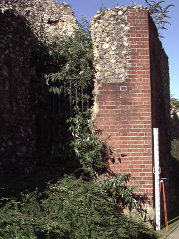
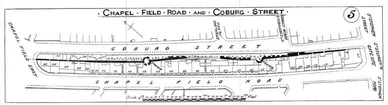
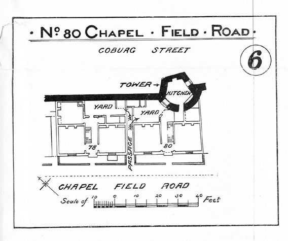
IntroductionThe longest single section of the city wall was between the Gate at St Giles and St Stephen's Gate. The wall, shown clearly on Cunningham's map of 1558, was some 675 metres long with 229 battlements and six intermediate towers. Although this is the highest part of the city, the ground is relatively level rising just 4 metres between the gates. A substantial section of the wall survives at Coburg Street and in many ways this is the most prominent and most seen section of the wall, at one of the main entrance points to the city and close to one of the main shopping streets. The surviving section of the wall at Coburg Street is just over 240 metres long and, though there are several wide breaks or breaches, it runs from the south-west corner of Chapelfield Park to St Stephens. The fourth tower of the original six between the gates was at the north end of the Coburg Street section, at the south corner of Chapelfield Park, at the end of the road now called Chapel Field East. It was probably demolished in the late 18th century. The two intermediate towers that survive form the main features of the external elevation of the Coburg Street section. The fifth tower is polygonal, standing to a height of 6.5 metres, [1]and the sixth or south tower with a horse-shoe shaped plan survives in a more derelict state towards the south end of this section. [see report 24] The wall between the surviving towers stands at over 5 metres high in some parts and the line of the internal walk along the top of the wall can be seen clearly in several places showing that in those parts just the narrow outer parapet has been lost. The parapet would have added almost 2 metres to the overall height of the wall. The crenellations of the parapet - the merlons, embrasures and intermediate loops - would have been formed in brick as on the surviving fragments at Ber Street and Carrow Hill. It is possible that the north part of the Coburg Street section, on either side of the polygonal tower, has never had an arcade on the inner side and would have linked through with the plain section of wall along the west side of Chapelfield Gardens. This and surviving documentary evidence implies that this section of the wall may be one of the earliest parts of the defences where a bank and palisade were first replaced by a more substantial wall in flint and mortar. Map evidence suggests that there were no buildings close to this section of the city walls until the 19th century, apart from a block of houses on the site of the present Co-op store which faced on to St Stephens and on to Back St Stephen's, now Coburg Street. Generally, around the medieval city there was a road or lane immediately against the city side of the wall which is marked on early maps as 'the way inside the wall'. All the obvious repairs and patches along the wall on both sides at Coburg Street appear to be the consequence of building houses, yards and outbuildings hard against both sides of the wall in the 19th century. All these houses are shown on a survey plan published in 1910. [2] The extent of alterations and encroachment into the fabric of the wall can be seen at the site of number 80 Chapel Field Road which had a narrow yard to the rear with the tower on the far side of the yard. A doorway was actually cut through the north-west side of the polygonal tower and the ground floor of the tower was converted into a kitchen and the upper chamber was used as a bedroom. [3] The last of these houses was demolished in the 1970s when a dual carriageway, part of the inner city ring road, was constructed on the west side of the wall and a narrow foot path was built on the east side bounded by mauve/grey brick walls. Small-scale archaeological excavations across the line of the wall and in an area behind the wall were undertaken in 1969, 1972, 1973, 1974 and 1975. The general conclusion in the reports was that the medieval wall here had been built with little or no foundations and was in some places built on a level of loose sand. There is also the suggestion in these reports that the wall was built on the line of an earlier bank which itself had an outer defensive ditch. The outer ditch, on the west side of the 13th-century wall, has been loosely filled with building debris. In the construction of a new wider road on the outer side of the wall in 1974/5, a regular and gradual slope was achieved by general levelling along the line of the wall. This exposed much of the lower levels of the wall particularly in the centre of this section. At the south end of the wall on the city side, the present pavement is as much as 800 mm below the medieval level. The shallow foundations of the original construction and this recent undermining have caused some sections of the wall to settle into the ditch and lean outwards. A major redevelopment of the factory site on the east side of the wall is at the planning stage and it has been proposed that the foot path on the inner side of the wall should be widened and the setting of the wall enhanced as part of that scheme. |