City walls survey
23 Coburg Street North
|
|
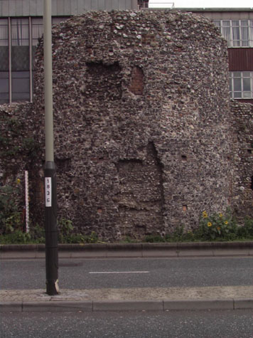
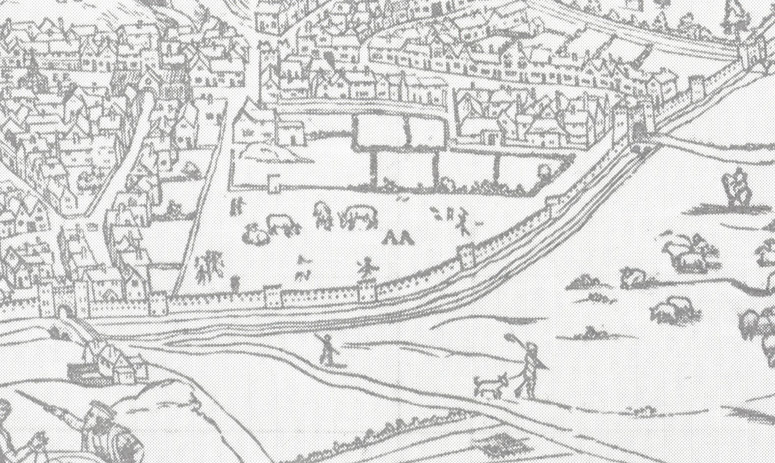
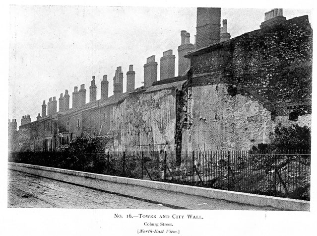
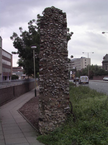
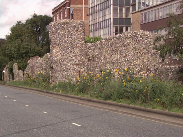
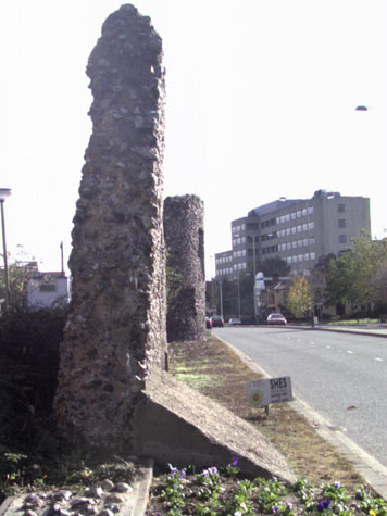
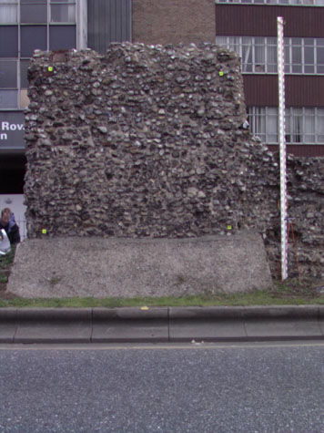
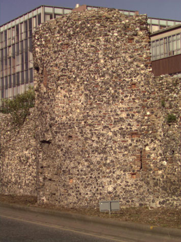
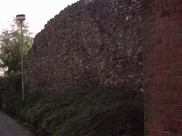
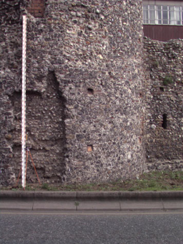
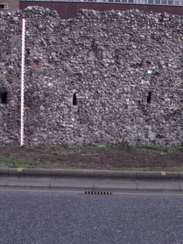
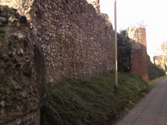
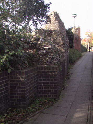
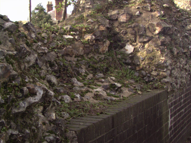
Historical Background ReportGeneral description of the historic fabric:To the south of Chapel Field East, following the line of what was Coburg Street, at present the western edge of the Nestle Factory site, there are five separate sections of wall between the south-west corner of the park and the site of the gate of St Stephen. [23-01 Map] There was an intermediate tower at the north end of this section but that was demolished in the 18th century when the wall was breached and a way through the wall created for the road now called Chapel Field East. [23-02 Plan] At the centre of the section are the remains of a substantial two-storey polygonal tower, rounded to the outer side and three-sided towards the city. [4] At the south end, south of the tower, the bases of a number of arches survive on the inner side of the wall.[5] These all supported a wider wall walk that appears to have continued for the full length of this south section as far as the gateway at St Stephens. The arches and wall walk may not be a primary feature of the 13th-century wall. Documentary evidence:Because no documents have been discovered to date precisely the construction of the flint wall and the towers in this section, it has been assumed that, as elsewhere in the city, they were begun in the late 13th century. However some references in early documents suggest that part of this wall could be one of the first sections of the flint wall to be built and may date from about 1253. Parts of the Saxon and Norman settlement of Norwich were protected by a ditch and bank and many of the principle streets were laid out then so the site if not the structure of many of the gates may have dated from the 12th century. Although the citizens of Norwich were granted a licence by Henry III to enclose the city in 1253, it is generally believed that the flint-built wall was not begun until the raising of the first murage tax in 1294.[Fitch page v and page viii] However, reference is made to a wall (not a bank or ditch) in Chapelfield about 1256 (16th Edward I). In a Leet Roll from the 16th year of the reign of Edward I (1255/1256) it was recorded that the millers of the Prior of Buckenham had undermined the ditch between St Giles Gate and St Stephen's Gate and 'made a purpressure under the walls.' Purpressure generally refers to illegal enclosure or fencing in of land. The Prior's mill was in 'Chapply Field.' [Fitch page 12] Furthermore, in 1266 or 1267 John the Carpenter sold all 'his said messuage lying near the Gate of Needham', (St Stephen's Gate) to the Citizens and Commonality of Norwich, 'for their more convenient building of the wall of the city there.' [Dom.Civ. quoted by Fitch page 12] Throughout the medieval period the land here inside the walls seems to have been open without buildings. Known as Chapel Field, it takes its name form the chapel of St. Mary which stood on the site. Blomefield notes that in 1402 this chapel was a meeting place for assemblies. [Blomefield, page 119] In 1406 the citizens of Norwich 'claimed four acres and an half of ground which belonged to Chapel in the Field ... lying in Chapel-field Croft, within the city ditch, on which it abutted south...' [Blomefield, page 124] This open area was much larger than the modern area of Chapelfield Gardens and extended south almost to St Stephen's. Blomefield cites the last leaf of the Book of Customs, which notes that along this stretch of wall between St. Stephen's and St. Giles gates were 229 battlements on the walls and towers. [Blomefield, page 98] The Norfolk Annals for 1852, compiled from articles in the Norfolk Chronicle, reports that on the 17th of April, pleasure gardens now called Chapelfield Park were opened by the Corporation. [Annals, volume I, page 11] An entry for 1867 explains that after being closed for some months, the gardens were re-opened, with 'several portions of the city wall ... removed, and railings erected, and efforts ... made to level the area'. [Annals, volume II, page169] It is likely that that was the stage when much of the wall between the Drill Hall [Report 21] and the surviving tower in Chapelfield Gardens was demolished. Map evidence:Cunningham's map of 1558 is ostensibly a view of the city from the west and shows clearly the wall between St Giles and St Stephen's. [6] Both gateways are depicted with bridges before them, both with two arches. The ditch in front of the wall is wide and appears to have a considerable amount of water in it. The view shows just five intermediate towers, all crenellated. It is impossible to make out any other details although the two towers at the St Giles end appear to be flat towards the outside ... that is of square or rectangular plan. All the sections of wall between the towers have distinct arrow slits. The area inside the wall is very open with cattle grazing. There are houses along the north side of St Stephens and although Back St Stephens (now Coburg Street) had been laid out, there were houses only on the south side and the north side was open to Chapelfields. By 1696, the date of Cleer's map, the open ground inside the walls had been bisected by a lane on the line of the modern Chapelfield East running directly up to the foot of an intermediate tower. There were no buildings along the lane on either side and no buildings against the wall itself either on the inner lane side or the outer ditch side. 'Chapply Field House' on the east side of the plot was obviously a substantial property and was set back from Chapel Field Lane, the extension of Horsemarket which is now called Theatre Street, with formal gardens laid out to its north. The map does not indicate a ditch on the outer side of the wall ... simply lanes hard against the wall on both sides. The map shows only four of the intermediate towers and certainly omits the southern horse-shoe shaped tower that survives. Kirkpatrick, on a map of about 1714 [Castle Museum and Art Gallery NWCHM 1894.76.1682:F] marks just 5 towers between the gates. He shows clearly both the polygonal tower and the horse-shoe shaped tower to the south but omits a tower at the end of Chapel Field East. He shows two towers on the west side of what is now the park and also the first tower on the site of the Drill Hall at the north-west corner of the park. There are still no buildings shown close to the wall on King's map of 1766 but one version of this map appears to show the tower at the south-west corner of the park still standing. Hochstetter's map of 1789 shows the park much as it is now and still no buildings against the wall itself. Sections of the wide ditch are clearly marked particularly at the south end and it appears that the water in the ditch was used for watering cattle before they were brought into the city. The wall at the north end is not shown with a breach through it but nor is the intermediate tower here shown. Morant's map of 1873 shows houses built against the wall on the outer side. The plans of these houses with their small yards and outbuildings are shown in detail on the 25' Ordnance Survey map of 1883. The plans of the houses against the wall are also reproduced in the survey of 1910 [Report by A Collins, map 5]. The south end of the wall was still standing so at least 15 metres of the wall has been lost since 1910. The 1910 plan also shows that the wall between the towers curved inwards. It is not clear if this feature of the construction was defensive, providing better sight lines between the towers, or topographical, avoiding a ditch or drain. Historic views and historic photographs:An undated nineteenth-century water colour by Henry Ninham, 'Part of the Wall by Chapelfield Gardens' [NCM 1054.76.94], shows a doorway in the wall, with wooden door in situ, with brick edging to the top of the arch. The inner mouldings are of stone. The wall is visible to the right and left of the door, but not to the height of the battlements. What appears to be a putlog hole is visible to the right of the door. There is some ambiguity about the identification of this drawing as another version in the Castle Museum is identified as being in Bracondale. There is a view of the polygonal tower from the south east in the Castle Museum. [NWHCM 1922. 135.FAW 93.F] that shows the doorway on the inner side still unblocked and presumably in use. It also shows a square super structure on top of the tower with a gabled roof with the ridge running north south. This appears to be secondary although there is a doorway in the south gable at the level of the wall walk. [7] Some of the surviving 14th-century documents for the repairs and upgrading of the wall by Richard Spynk indicate that some of the gates had thatched roofs. Is it possible that some of the intermediate towers retained rather more vernacular features than the crenellated battlements we might now imagine that they had originally? The Archaeological Society at Garsett house holds copies of several photographs of the Coburg Street wall with several showing major work in progress. One is dated March 1908 and shows the arches at the south end propped with timbers as the houses against the wall were demolished. These photographs show clearly just how much of the wall collapsed as the houses and buildings against it were removed. [8] The Society also holds photocopies of a proposed guide to the wall dated 1979. Archaeological reports:An excavation at 42 Chapelfield Road in 1972 by J Roberts for the Norwich Survey examined the nature of the city wall foundations. Trenches, dug at right angles to the city walls, revealed that the foundations were very shallow, and had been cut into natural sand. The fillings of the city ditch along this stretch of wall were found to be rubble that dated from the late 18th- to 19th-century. [SMR NF236] An excavation for a sewer by the City Engineers, for 44-58 Chapelfield Road immediately to the north of this section, prior to the construction of the ring-road in 1973, took place within the fill of the city ditch. The excavation revealed that the fill was mainly of foundations and modern demolition/backfilling. [SMR NF196] In 1974, sewerage trenching operations in front of 60-102 Chapelfield Road were carried out outside the city wall in advance of constructing the inner link dual carriage way. This work extended north-east to south-west along the outer side of the city walls and revealed 'Disturbance almost wholely of the 18th century - 20th century for houses backing onto the city wall with rubble from their demolition. [SMR NF196] In 1975 an underpass for the inner link road was dug from inside the city wall to the west pavement of Chapelfield Road. [SMR NF260] No trace was seen in this section of the defensive ditch. SMR NF372 gives a full account of the transition of the area, and a secondary file exists, but does not contain much information of use which is directly relevant to the walls or towers in this area. A Department of the Environment Report [HSD9/2/1005 part 6 contained in Gressen Hall file 384] mentions maintenance work to be carried out on the section of wall and towers from Chapelfield Road North to St. Stephen's Gate in 1988. CONDITION SURVEYList of known repairs:Not available at this stage. Photographs in the NNAS collection at Garsett House shows the tower with extensive scaffolding. Presumably this was taken when the surrounding houses were demolished. Certainly extensive work was required then to consolidate and stabilize the walls. Summary of present condition:The first two sections of wall at the north end are short and both are in a poor state of repair [23-04 Ext Elev]... both lean outwards markedly. [9 & 10] The first section is 3.2 metres long, just 3.6 metres high and only about 1 metre thick. After a gap of 4.5 metres, the second section is 6.6 metres long, 4 metres high and about the same thickness as the first section. [23-05] Both sections have been extensively cut back and damaged by the building and subsequent removal of houses hard against each side. [11 & 12] The map of this section of the wall published in 1910 shows the houses and their arrangement clearly. Numbers 60, 62 and 64 Chapel Field Road were on the west side and 73 Coburg Street was against the inner side of this section of the medieval wall. The level of soil on the inner side of the wall has been lowered by between 200 and 400 mm to allow for the narrow passageway of the footpath between the wall and the north gateway of the factory. [23-04 Int Elev] Bricks and rubble have been inserted below but archaeological excavations in this area have shown that the medieval wall had very shallow foundations and presumably there is little or nothing below these sections of wall to provide support. After a gap of just over 16 metres, now occupied by a bus stop with footpaths running down at angles from the main road to the inner footpath, is the main section of wall. This is just over 71 metres long and includes, approximately at the centre, the substantial remains of a polygonal tower.[13] The section north of the tower has evidence for a series of loops which are widely spaced with about 6 metres between each loop. This suggests that there were no arches on the inner side to support a wall walk. The wall has little facing flint work on the inner side and much of the core work is exposed. There are no areas of brick arch surviving and there is no disturbance or obvious rebuilding at the junction of the inner side of the wall and the north side of the tower that would indicate that an arcade has been demolished. A surviving loop in the north wall of the tower, that looks along the inner side of the wall would also suggest, from its position, that there was no arcade here. [14] On the outer side much of the flint work has been repaired. At the end of the 19th century there were houses all along the outside ... numbers 78 and 80 Chapel Field Road were built close to or hard against the wall with narrow yards to the rear and outbuildings built against or into the wall. This section is distinguished by an area of rebuilt wall with brick quoins and strings forming a panelled section 4.6 metres long and 4.2 metres high. [15] This form of repair and strengthening of the face is a technique used in vernacular domestic buildings and is found elsewhere in the city. Most of the facing flint on both sides at the top has been lost although the top of the wall is in a relatively good state of repair with few flints being shed. Presumably, this is the consequence of good repairs in the 1980s. The north end of the wall, however, is in a dangerous state. It is very thin where the facing flints have been lost and the wall here is less than 800 mm thick. More serious, where the pathway has been cut down on the inner side of the wall the base has been undermined. This is also the section of wall closest to the roadway itself and presumably the wall is effected badly by traffic vibration. It leans outwards and has been propped on the outside by a large wedge-shaped block of concrete. [16 & 17] It is not known if the wall here has been underpinned. This section is certainly in need of an engineers assessment with a report on its stability. It may need urgent repairs to prevent collapse. On this section and on the first two sections there are long horizontal cracks on the inner side at the original ground level and the weight of the upper part of the wall is hinging over this point. The polygonal tower is rounded in plan towards the outside and three-sided towards the inner side of the wall. [18 & 19] Its wall stands to 6.3 metres high on the outside and 4.3 metres towards the inner side. On the inner side of the tower the ground level has been lowered by 800 mm. A clear line for the earlier level can be seen across the lower part of the flint work. Above this line the angles of the tower are well built in brick. [23-07 Tow Nor Elev] [23-08 Tow Wes Elev] [23-09 Tow Sou Elev] [23-10 Tow Eas Elev] The tower was of two storeys with a lower and an upper chamber. [23-11 Tow Nor Sec] [23-12 Tow Wes Sec] [23-13 Tow Sou Sec] [23-14 Tow Eas Sec] The lower chamber was entered from the inner lane of the wall by a doorway through the central flat side of the polygon. The doorway had a shaped brick head and part of the brick hood moulding of the doorway survives. This doorway is now blocked and the tower is entered by a breach on the south side which is secured by a modern iron gate.[20 & 21] The upper chamber was presumably accessed from the wall walk. There is no evidence in the lower chamber for an internal staircase. Internally the tower is 4.1 metres across and almost the same dimension from the outer to the inner wall. In the lower chamber there were arrow slits or loops on both the north and south sides to look along the line of the outer wall. These were later made into windows but are now blocked. In the 19th century the tower was used as part of the accommodation of number 80 Chapel Field Road with a kitchen on the lower level, reached from the yard of the house by a doorway cut through the outer wall of the tower. The outline of this inserted doorway survives on the outside but it is now blocked. [22] Inside the tower, the present floor level is about 300 mm above the pathway and it is tiled. Presumably this floor survives from the period in the 19th and 20th centuries when the lower part of the tower was a kitchen for the house facing on to Chapel Field Road. It is unclear if the medieval floor level survives below this. The upper chamber of the tower was also incorporated into the house and a doorway, inserted at the upper level, can still be seen on the south-west side of the tower but it too was blocked when the house was demolished. There is no indication inside the tower of the structure of the medieval first floor. However, the upper part of the wall is narrower and steps in on the inside and in the 19th century this ledge would have supported a wooden floor. There is no evidence for vaulting in the tower for either chamber. The walling of the tower is generally in good condition. On the outer face the mortar of the flint work is galleted. [23, 24 & 25] South of the tower is a substantial section of wall some 25 metres long. This stands 4.5 metres high, almost its full original height, with clear evidence on the inner side for the level of the wall walk and the lower part of the outer parapet wall survives though the top has been much rebuilt and has lost all its crenellations. [26] On the outside of the section can be seen the remains of 5 loops or arrow slits. These are spaced irregularly and are much closer together than loops on other sections of the wall. [27 & 28] The loops here are between 2.4 and 2.8 metres apart. There is is now no obvious explanation for this odd spacing of the loops. Possibly it suggests a sequence of building where perhaps sections of the wall were constructed between standing features but such a sequence could only be reconstructed if there was an extensive archaeological investigation of the footings of the wall on both sides. On the inside, apart from at the low south end, there is no evidence for wall arches. [29] At the south end the wall drops in height. Here there are the remains of three arches. [30 & 31] In this section the wall is at most a metre high and in parts the facing flints of the face are only 300 mm high (above the medieval ground level). Much of the wall here is exposed core work. The facing flint on the inside is in a relatively good state of repair. There are a number of small blockings and patches with brick though it is not known what these indicate or what they respect. Several square blockings at an intermediate level look like beam slots and there appears to be the horizontal scar of weathering for a lean-to roof. However, map evidence indicates that in the 19th century there were no houses against the inner side of the wall anywhere along this section. The medieval ground level has been lowered by at least 800 mm on the inner side and the wall is now under built or in effect supported on a retaining wall built in mauve bricks. This is the part where the footpath is at its narrowest and on the factory side of the path there is a boundary wall in the same brick which forms a kind of gully here. Presumably the ground was levelled to produce an almost flat if very narrow public path way. Photographs of the inside of the wall on either side of the tower now in the collection at Garsett House show just how much of a bank was cut away when the footpath was created. These photographs are not dated but were probably taken in the 1960s. There is a wide gap of just over 25 metres in the line of the wall before the fourth section. Six complete arches in this section have been lost. [24-02 Plan] Principal conservation problems:1. SettlementAt the north end of this section of wall the first two short sections and the north end of the section with the polygonal tower all have serious problems with poor or no foundations and the removal of ground on the inner side. Documentary and archaeological evidence [see Barn Road report] suggests strongly that this section of wall was built on an earlier defensive bank. At Barn Road the new flint wall was set on a relatively shallow foundation trench filled with layers of flint and mortar. On the outside towards the ditch some stability was provided by taking the wall down into the ditch - at River Lane the outer side of the wall continues at least 2.4 metres below the current ground level. On the inner side it was presumably the bank, up to a metre high, that provided some support and some protection from weathering. Where this bank has been removed at Coburg Street the consequences are apparent. It is recommended strongly that a specialist engineer's report is commissioned to assess and monitor the settlement of the wall at the north end of this section. It is also recommended that the bank should be reinstated for the whole length of this section of wall. 2. Shedding flints on the face and top of the wallParticularly a problem on the two north sections and on the top of the wall to its south. The section with the polygonal tower is in a good condition and has been repaired recently. Few flints are loose. 3. Intrusion of woody stemmed plantsNot as much of a problem as on many sections of the wall. Small area of buddleia on the outer side immediately north of the polygonal tower should be cleared. Note: Since this report was drafted the trees have been removed but this recommendation has been left in as the self-seeded trees and bushes in the tower should be removed before they become established. There are a number of well-established self-seeded bushes within the polygonal tower and these should be removed. 4. Deterioration of the brickworkThis is a common problem throughout the circuit of the walls. Once the wall walk deteriorates and collapses or in part collapses, water gets into the core and the wall over the arches is particularly vulnerable. The brick is relatively soft and once water penetrates the brick work crumbles and breaks away. The arches at the south end of this section have collapsed and no facing bricks survive. The brick hood moulding on the blocked doorway on the east side of the polygonal tower is in a poor state and much of the profile has been lost. Bricks in the loops and putlogs, to some extent protected, are in good condition. |