City walls survey
23 Coburg Street North
|
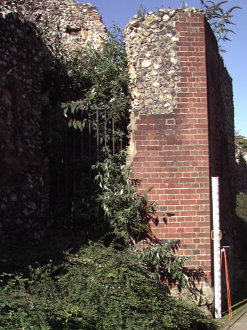
Conservation PlanFor the conservation plan, the surviving wall and the two towers between Chapelfield Gardens and St Stephens are considered together as any action here has to be part of a coherent scheme. The present setting:To the south of Chapel Field East, following the line of what was Coburg Street, at present the western edge of the Nestle Factory site, there are five separate sections of wall between the south-west corner of the park and the site of the gate of St Stephen. Along the west side of the wall, over the line of the outer ditch, is the busy dual carriageway of the inner ring road with a narrow verge between the wall and the road that is up to 6 metres wide but is generally much narrower. On the east or city side of the wall is the site of the Nestle factory, now empty and awaiting redevelopment. This factory is primarily a group of large buildings that date from the early and mid 20th century. Building of the first factory on the site, Caley's, was begun in 1921. The buildings are of various dates and styles including brick and glass and steel frame. At the north end, close to the wall, the factory rises through five storeys. The car park and forecourt of the factory has encroached across the original line of Coburg Street leaving just a narrow footpath that is hard against the inner side of the medieval wall and is defined by a mauve brick wall between the path and the factory. Generally, the landscape setting of the wall between Chapelfield Park and St Stephen's is very poor. The dual carriageway of the inner ring road is hard against the outer side of the wall. There is a grass verge between the road and the wall but in places this is very narrow ... as little as 2 metres ... and the outer face of the main polygonal tower, at the centre of this section, is set just 600 mm back from the high concrete kerb of the road. Potential medium or long-term improvements recommended for the surroundings:Although an attempt is made to maintain the outer grass verge, and there are some young trees planted along the outside, this section of the city wall is dominated by the road and its fast-moving traffic. Given the character of the road and its traffic, there is little that can be done to enhance the setting of the medieval wall. The grass should be regularly maintained, planting should be kept to a minimum and the verge should be regularly maintained. To be positive, perhaps the severe setting of the wall does give an impression of the austerity and impregnability of the medieval defences ... they were not supposed to look attractive and inviting in the 13th century and were certainly not constructed as an attractive landscape feature. Good lighting at night could produce a much more dramatic effect. This section of the city wall is extremely important being close to one of the main access roads in to the city. On the inner side of the wall, the boundary of the former Nestle factory, is much too close to the wall and the public path between the wall and the factory is little more than an alleyway. Many pedestrians using the pathway cut through the gaps in the wall and cut across the dual carriageway. The path has moderately heavy pedestrian use and it appears to be particularly awkward to negotiate the narrow sections with wheel chairs or push chairs. At its narrowest point the path is just 1.2 metres wide. The ground inside the wall has been taken down well below the medieval level to create a low almost-level gradient for the path. Where necessary, the medieval wall has been directly under-built in brick or where there is space, a low retaining wall about a metre high has been built in brick, just in front of the defensive wall to create raised beds. These are planted with evergreen shrubs. These retaining walls do, to some extent, protect the flint work by keeping people back from the wall but particularly in the arches at the south end, these bushes quickly collect rubbish. The archways, particularly at the south end, are used as toilets even during the day. If more space can be created in front of the archways, then the ground level should be returned to its medieval level. It is unlikely that grass can be made to grow within the arches, which face north east, but careful thought should be given to constructing a hard surface ... either gravelled or cobbled ... to, in effect, re-establish the medieval lane or way under the wall. The excavation at Barn Road established that the lane inside the wall there was cobbled. In addition to improving the setting of the wall, returning to the medieval level could provide some additional support to the wall and where appropriate, could be used to cover over any remedial engineering work to underpin and stabilise the wall. Trees and planting on the inner side should be kept to a minimum. If more space is provided against the inner side of the medieval wall then serious consideration must be given to constructing barriers across the large gaps between the standing sections of the wall. The present brick retaining wall is high enough to stop most people from climbing up and trying to cross the dual carriageway but this would no longer be a deterrent if the ground level was raised. The design of any barriers would have to be considered very carefully so as not to detract further from the medieval walls and towers and their setting. Is it possible that the line of the wall could actually be rebuilt in flint to a height of a metre or so? It might even be considered appropriate to rebuild the wall to its full height. Photographs and records will show clearly that this work is not medieval. A solid wall would provide some protection against sound and pollution from the carriageway. This is the only section of the city wall where a recommendation has been made to restore or rebuild the wall on the original line. Landscape report by Christine Boswell:These sections of City Wall are adjacent to the very busy Chapelfield Road with a south facing margin of between two and 10 metres. To the north side is a narrow planting strip and a footpath adjoining the Nestle site, soon to be developed. The medieval base of the wall is quite high and emphasised by the engineering brick wall which retains the City Wall down to the pavement. The existing planting on the north side is dense pendulous shrub cover: Cotoneaster and Symphoricarpus which achieves its objective in covering the retaining wall. The close proximity of the public footpath with the wall results in a deeply shaded, cold and damp footpath. The south facing side of the City Wall has been cleared of the dense shrub cover and over the past year has been imaginatively planted with a succession of lively and exciting planting schemes, from miniature spring bulbs to wild flowers and sunflowers. These schemes have been refreshing and have brought the area to life. At the time of this report (November) the annual planting had died down and the soil is bare except for three trees in the central section where the wall is missing. The road signage is large and obscures the walls. Adjacent to the existing bust stop there are two beds of winter pansies. The tower is overgrown with Buddleia seedlings. Recommendations:North side: The opportunity provided by the redevelopment of the Nestle site to alter this section should not be overlooked. The Historical Buildings Surveyor recommends that the missing section of wall is rebuilt along its original bowed line and that the medieval base is reinstated as the ground line. A banked area of 7 to 10 metres from the wall base to a new retaining wall at seat height (450mm above GL) could then be mass planted with woodland perennials providing attractive and varied leaf patterns, foliage colour and flowers throughout the year but at its peak in the spring. The footpath route could be well away from the shadow cast by the wall and the new planting would be an attractive outlook for the new development. South side: The wall should be spotlit in places, particularly the section nearest the roundabout as it is the entry point to the City itself. The towers and other features should also be lit, the lighting points at ground level flooding upwards. The signage, although necessary is unattractive. If any structures are planned to span the road then a proposal to suspend signage should be considered. The present planting policy for the south side should be continued but perhaps interspersed with some low perennial planting that tends towards the evergreen, eg. Geranium types that retain their foliage - Geranium phaeum variegatum and small Hebe types that form rounded shapes. Archaeological impact assessment:Generally in this report, archaeological investigation has only been recommended where there appears to be a direct threat to the buried parts of the wall. However, potential areas for research, to answer specific questions, have also been suggested in case the opportunity arises from building work or excavations for services to uncover certain areas. Here at Coburg Street the redevelopment of the Nestle Site presents such an opportunity for focused investigation particularly if the plan proposed for a new access road at the north end is allowed to proceed. This would cut down through the base of the wall, and, as well as cutting down through an earlier bank if there is one in this section, it could uncover the base of the lost tower fixing its position exactly. Map evidence suggests that the intermediate tower was at the end of Chapel Field East. The wall here has been breached since the late 18th century and although there is not, at present, vehicular access from the dual carriageway into Chapel Field East, there is an access road from the dual carriageway into the Nestle factory site. In the most recent application for new buildings on the factory site it is proposed that this should form the main access point for the new development. Any work at this entrance for the construction of the road or for the provision of services such as drainage will cut down through the archaeological levels. Archaeological excavations in this area close to the walls or across their line have suggested that the wall here was built on sandy soil and had little or no foundations. However, any excavation at the north end of the section, at the junction of Chapel Field East, could, potentially, reveal the lower part of the intermediate tower and will cut through the outer ditch. It would also disturb the line of the lane immediately inside the wall ... the so called 'way under the wall' ...and could expose any ditch or bank that preceded the present wall. It is crucial that any archaeological investigation of this part of the wall should try to determine if it was built in a single phase or if it was built in several phases between 1253 and 1340. It is not certain if the arcade at the south end was a primary feature or was added to an earlier wall. This might be determined by an excavation. The higher soil level on the inner side of the wall has been taken elsewhere to imply that the wall had a raised lane on the inner side that was on an earlier bank. Again this could be determined by evidence from any excavation. CONSERVATION REPORT WITH RECOMMENDATIONS FOR ACTION1. Immediate attention
2. Requires regular monitoring
3. Long term conservation
4. Improvements to the settingPriority
Long term
BIBLIOGRAPHY:Blomefield, Francis, An Essay Towards the Topographical History of the DOCUMENTARY REFERENCES:N.R.O. Book of Customs ARCHAEOLOGICAL REPORTS:Gressen Hall file 384 HISTORIC ILLUSTRATIONS:Norwich Castle Museum and Art Gallery: |