City walls survey
30 Richmond Hill Wall
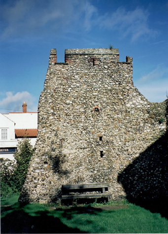 [1] The outer side of the wall from the south. |
IntroductionAlthough this is only a small fragment of the wall it gives by far the best impression of what the wall would have looked like from outside the city in the Middle Ages. [1] The wall here survives to its full height of over 6 metres with part of the crenellation with a brick embrasure and brick coping on the merlon. This section also has an intermediate loop in the centre of the merlon which may be an arrangement repeated elsewhere. Only one thing is missing. The wall is neither as impressive nor as menacing as it was in the 14th century when it would have risen up on the far side of a deep and wide outer ditch. The surviving wall is immediately east of the site of Ber Street Gate and forms a sharp angle about 10 metres from the gate with the wall turning south to run down Bracondale. Several historians have commented on this and suggested that this reflects a change in the area enclosed by the defences implying that at some stage the defensive wall or bank continued east and ran down the hill to King Street and the river. The reason for the change of alignment may actually be more practical. The gate at King Street was established at an early date, certainly there by the second half of the 12th century, so the full extent of the city to the south was established at an early stage. The wall along Queen's Road and down Bracondale follows a general line from north west to south east before turning down Carrow Hill. It is broken by the line of Ber Street which cuts across the line of the wall at a sharp angle. Generally, it is easier to build a bridge and the fore works of a gate at right angles to its ditch. In the centre of Cambridge the main street near Petty Curie turns first to the left and then within a few metres back to the right with no reason for this being obvious in the modern townscape. However this was where the medieval Kings Ditch, which is now in a culvert, cut across the line of the road at an angle and the bridge over the ditch respected the alignment of the ditch rather than the direction of the road. At Ber Street, as this was one of the major routes into the city leading directly to the Castle from the south, the bridge respected the line of the road. So that the bridge could still be built straight over the ditch, the line of the ditch was turned first to the east, just before the gate to the west, and then turned sharply, in the section that survives, to resume its course down Carrow Hill. The surviving wall is in two sections. The part near the gate has a narrow wall walk on the inner or north side but there is no evidence for an arcade here. The section after the turn to the south has part of an arch on the inner or east side. Presumably, the first section of the wall after the gate was too short for an arcade to be constructed. The gateway is thought to have been flanked by turrets and presumably access to the wall walk was from the upper chamber of the east turret. |