City walls survey
30 Richmond Hill Wall
|
|
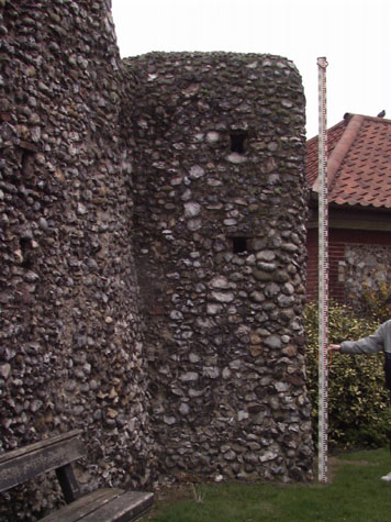
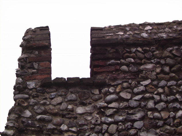
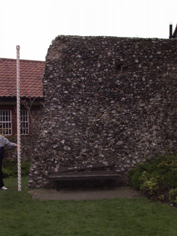
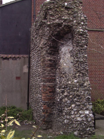
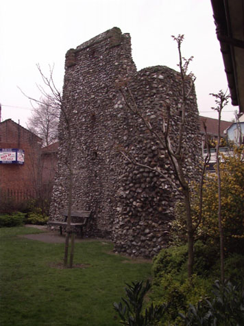
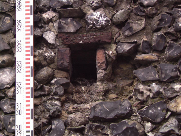
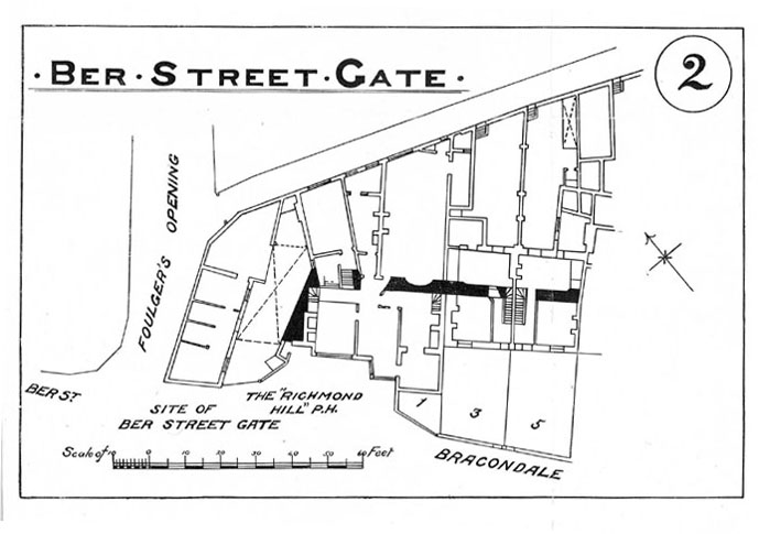
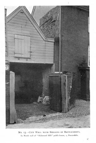
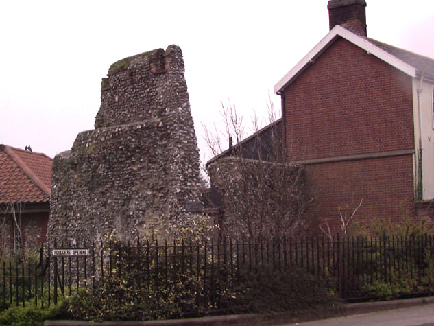
Historical Background ReportGeneral description of the historic fabricThe surviving wall is in two separate sections with a breach of just over 4 metres. [30-02 Plan] The section of wall immediately east of the site of Ber Street Gate runs primarily west to east and is 7.3 metres long and 6.3 metres high. At the east end the wall turns to the south with an internal angle of 105 degrees. [2] The stub of wall surviving beyond the angle is just 1.3 metres long on the side towards the ditch. On the first section to the north [30-04 Ext S Elev, 30-05 Ext W Elev & 30-06 Int N Elev] the wall walk and the outer parapet survive. [3] The wall walk is now just 400mm wide which suggests that at least part of the face of the wall on the inner or north side has been lost.[4] The parapet is 1.85 metres high though it appears to have lost the top courses of the brick copping. On this part of the parapet two embrasures survive formed in the flint work in brick. They are 400mm wide and were at least 620mm high and define a merlon 2.2 metres wide. [5] After a gap of 4.3 metres the wall resumes and this section running in to the gable end of the house in Bracondale is just under 5 metres long. [6] On the east or inner side is the inner most part of the south side of an arch that supported the wall walk. [7 & 8] The arch continued into the area now lost and the dimensions and its position imply that this was the first arch of the arcade that continued down Bracondale and joined with the series of arches surviving on Carrow Hill. The remaining part of the arch is 1.5 metres wide but when complete would have been about 2 metres wide overall if it followed the dimensions of arches surviving on other sections. Only 370mm of the depth of the jamb remains, and again based on the dimensions of surviving arches, over half of the depth of the arch has been lost on the outer face. No bricks survive from a loop in the outer wall within the arch though the flint work appears to respect the south side of a loop here.[30-07 Int E Elev] Abutting the north gable of the house is an area of brick which probably marks the north jamb of the next arch. Putlog holes lined with bricks survive on both sections at two heights. [9] Curiously the two levels of putlogs are unusually close together where on other sections the putlogs divide the height of the wall between the ground and the wall walk into three almost-equal heights. Documentary evidence:No medieval documents have been found in this search that refer specifically to this section of the wall. In 1748 the City granted a one hundred-year lease on part of Butter Hills to be made into a pleasure gardens. Views from the city wall towers were a feature of this. [SMR NF26487] The Norfolk Annals for January 18, 1807 referring to Ber Street, mention 'A length of about 40 yards of the city wall' falling 'with a tremendous crash'. Following this, the Grand Jury 'made a presentment, in which attention was called to the dangerous state of the wall.' [Annals, vol. I, page 54] It is unclear precisely which section of wall they refer to, but the Queen's Road section nearest to the Ber Street Gates seems likely, although it possibly refers to Richmond Hill wall. A similar entry in Blyth's directory of 1842 mentions this crash, noting that 'On January 18th, 1807, a great part of the wall near this gate (Ber Street) fell with a tremendous crash, killing four cows which were in an out-house, but fortunately no person sustained any injury. The ground has since been cleared and built upon.' [Blyth, page 4] Again no precise mention is made of which side of the gate this wall fell; it could be either Queen's Road or the Richmond Hill wall. In 1827 the Norfolk Annals records that on March 19th 'A large portion of the city wall at Richmond Hill Gardens, Norwich, fell into the Bracondale Rd, from the effects of a violent gale of the 17th.' [Annals, vol. I, page 266] Map evidence:There were medieval houses on both sides of Ber Street inside the walls right up to the gate and clustered tightly around the medieval church of St John de Sepulchre. However, all the 17th and 18th-century maps show the wall east and south of Ber Street Gate unencumbered by buildings. Richmond Hill or Botelers Hill is steep and appears to have been wooded. King's map of 1766 shows this area of woodland inside the walls and also shows clearly that the wall and it's crenellations and all the intermediate towers between Ber Street and King Street were standing. Hochstetter's map was published in 1789 and by then the ditch on the east side of Ber Street Gate had been filled in, at least in part, and there were garden laid out along the outer side of the wall. By 1830, the year of Millard and Manning's map, there were several buildings in front of the wall, including a building in the internal angle of the surviving wall, though the area inside the walls was still open being labelled as Richmond Gardens. There was already at least one break in the wall south of the surviving section though the tower at the corner of Carrow Hill was still standing, at least in part. The first edition of the Ordnance Survey map was published in 1885. All the houses along Bracondale had been built by then and the building in the return angle of the wall immediately east of Ber Street was identified as the Richmond Hill tavern. There was a building against the east or inner side of the surviving wall and a carriage arch marked against the north side of the section of wall closest to Ber Street. A more detailed map with the plan of these buildings [10] was published in 1910 in the report on the walls by A Collins. [Map 2 opposite page 12] This shows a fireplace built against the south side of the first section, a staircase built on the west side of the section running south from the corner and a large shallow niche cut into the east side of the second section. That plan also shows the wall continuing within the main cross wall of numbers 3 and 5 Bracondale. Historic views and historic photographs:The photograph of the wall published in the 1910 report [Collins, 1910, plate 15] shows the brick faced, three storey building in the re-entrant angle of the wall and an open carriage shed with timber boarded loft over that was built hard against the wall on the north side. The pub was demolished in 1931. [11 & 12] Archaeological reports:An excavation was undertaken by E M Jope in 1948 and the results were published in Norfolk Archaeology. Five trenches were dug, one running parallel to the north part of the wall on its north side but some 2 metres away from it and there was one trench running away from the wall towards Foulger's Opening. Three trenches were excavated on either side of the south section of the wall. The wall running down towards Bracondale was found to have been built on the crest of a bank of 'compacted loam about 1 ft thick.' 'By contrast,' the part of the wall closer to the gate, ' was shown to have foundations going down 5ft below the present surface and resting upon natural gravel.' For Jope 'This is very suggestive of part of an early stone gate structure (the gate is first recorded c. 1146) set in the line of an earthen bank, which the Barn Road excavation suggests was built, as is known, on the crest of this bank as late as the 1290s onwards.' CONDITION SURVEYList of known repairs:Not available at this stage. Presumably some restoration was undertaken in 1931 when the Richmond Hill public house encasing the wall was demolished. Summary of present condition:The wall is in very good condition. Generally the only areas for concern are the large areas of exposed core work on the north and east side, the crumbling inner edge of the surviving wall walk and the decayed state of brickwork in an arch on the east side. Principal conservation problems:There appear to be no serious problems with this section of wall 1. Shedding flints on the face and top of the wallThe common problem to all the sections of wall but here very important as this is the only section of the wall where the parapet survives. Fortunately the wall is too high and steep to be scaled so vandalism is not a significant problem. However, the surface of the wall walk has worn back. It is important to ensure that no more is lost which would undemine the stability of the parapet on the front edge of the wall walk. It is also important that the wall walk is monitored to ensure that water is running off and not permeating the core of the wall. Much of the north and the east sides of the wall are exposed core and areas where flints shed should be repaired so that problem areas do not deteriorate rapidly. 2. Intrusion of woody stemmed plantsRegular monitoring required in the Spring and Autumn. All root stocks should be removed rather than just trimmed back. 3. Deterioration of the brickworkThe brick of the parapet is in remarkably good condition. This was not inspected close up but much could have been replaced or restored when the Richmond Hill public house was demolished. Brick work in the surviving arch on the east side is more vulnerable and loose bricks should be fixed back with mortar. It is difficult to ensure the stability of brickwork like this when the front edge, the lower courses of the arch and the supporting jamb of the embrasure have broken away. |