City walls survey
30 Richmond Hill Wall
|
|
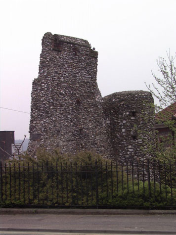
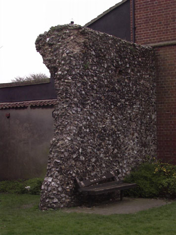
Conservation PlanThe present setting:The wall is on the east side of Ber Street just before it joins the junction of Queen's Road and Bracondale. [30-01 Map] A small park or garden enclosed by railings was constructed around the surviving wall after the Richmond Hill public house, built in the angle of the wall, was demolished in the 1930s. [13 & 14] There is heavy traffic on the main route along Queen's Road and Bracondale but less traffic on Ber Street although until recently Ber Street was the principal road. The fact that the bulk of the traffic passes some 10 or 15 metres to the south makes an amazing difference and the garden around the wall is remarkably pleasant as a place to sit. The narrow road to the north of the wall and the electricity sub station to the east are less attractive landscape features but still much better than the situation in many places elsewhere around the walls. The high thick bushes around the walls are attractive but they mask the wall and do cause security and safety problems. The large number of needles, condoms and beer cans dumped around the more hidden east side of the wall attest to activities which, though not strictly detrimental to the structure of the walls, could be seen as a problem if there is to be a more concerted effort to encourage tourists and visitors to look at the walls. It would be impossible to reinstate the ditch here, however desirable. Landscape report by Christine Boswell:This part of the City wall falls within a railed park enclosure which is well kept, lawned with perimeter shrub borders inside the railings. There is a plaque on the part of the walls which can be read from the pavement outside the enclosure. There are two park benches against the wall providing a sheltered place to sit. Recommendations:Clip perimeter shrubs to height of railings so that the walls remain visible from the raod and that the park does not become too private. Provide more informative signage about the wall. Provide up lighting for the walls and enclosure so it is a safe place at night. Archaeological impact assessment:Further work should be done to assess how much of the wall survives in the rear walls of the properties in Bracondale to the south of this section. Excavations in the area at the west end of the standing wall could uncover the east side of the gate and could establish if the gateway did, in fact, have an east turret. Conservation Report Summary with Recommendations for ActionImmediate attention
Requires regular monitoring
Long term conservation
Improvements to the settingPriority
Long term
BIBLIOGRAPHY:Blyth, G.K., The Norwich Guide and Directory (London: R. Hastings; DOCUMENTARY REFERENCES:No specific references for this section. ARCHAEOLOGY REPORTS:Jope, E.M., `Excavations in the City of Norwich, 1948', Norfolk Archaeology HISTORIC ILLUSTRATIONS:Ninham, Henry, `City Walls Richmond Hill Gardens', NCM 1929. 89:INT, |